|
Tag Archives: nasa
A Look At Voyager’s 40 Year Journey
|
Pence Vows: ‘American Boots on the Face of Mars’
|
Video: Former Obama admin official says climate agencies purposely mislead
A fascinating insider look from a scientist about how our nation’s government agencies spin data to push their agenda.
Former Energy Department Undersecretary Steven Koonin: “What you saw coming out of the press releases about climate data, climate analysis was, I would say, misleading, sometimes just wrong…”
Former Obama Official Says Bureaucrats Manipulate Climate Stats to Influence Policy
|
A whopping seven Earth-size planets were just found orbiting a nearby star
|
Astronaut tweets nighttime image of Colorado Front Range
Only a select few have the privilege of viewing our planet from space so those of us more grounded live vicariously through the images they send back. Astronaut Shane Kimbrough gave us a look at a lit up Front Range from Colorado Springs to Cheyenne in an image he tweeted out.
All the major population centers are clearly visible. The nighttime lights of Colorado Springs, Denver, Boulder, Fort Collins, Cheyenne and even Fort Morgan out on the plains are all visible. The Denver / Boulder office of the National Weather Service tweeted out a copy of the image labeled with the cities to provide some context.
Good morning USA! Cheyenne Wyoming and north central Colorado – Fort Collins, Greeley, Boulder, Denver, Colorado Springs. #CitiesFromSpace pic.twitter.com/4Z3lS0Wa6Z
— Shane Kimbrough (@astro_kimbrough) February 9, 2017
Amazing view of the Urban Corridor from Astronaut Shane Kimbrough as the International Space Station passed overhead! City names overlayed. pic.twitter.com/Fdb2Qh5uqm
— NWS Boulder (@NWSBoulder) February 10, 2017
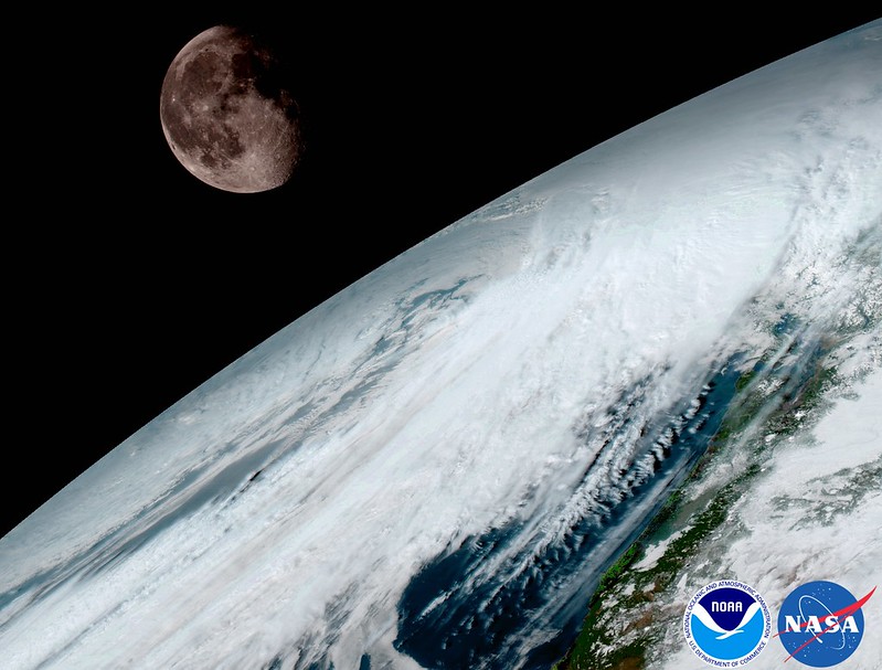
NOAA releases first images from new GOES satellite

NOAA released the first images from their new GOES-16 satellite and to say they are stunning would be an understatement. The new satellite, built in Colorado by Lockheed Martin, contains some of the highest resolution cameras and most advanced sensors in the world.
From NOAA:
Since the GOES-16 satellite lifted off from Cape Canaveral on November 19, scientists, meteorologists and ordinary weather enthusiasts have anxiously waited for the first photos from NOAA’s newest weather satellite, GOES-16, formerly GOES-R.
The release of the first images today is the latest step in a new age of weather satellites. It will be like high-definition from the heavens.
- Scroll down to view all of the new images released by NOAA
The pictures from its Advanced Baseline Imager (ABI) instrument, built by Harris Corporation, show a full-disc view of the Western Hemisphere in high detail — at four times the image resolution of existing GOES spacecraft. The higher resolution will allow forecasters to pinpoint the location of severe weather with greater accuracy. GOES-16 can provide a full image of Earth every 15 minutes and one of the continental U.S. every five minutes, and scans the Earth at five times the speed of NOAA’s current GOES imagers.
NOAA’s GOES-16, situated in geostationary orbit 22,300 miles above Earth, will boost the nation’s weather observation network and NOAA’s prediction capabilities, leading to more accurate and timely forecasts, watches and warnings.
“This is such an exciting day for NOAA! One of our GOES-16 scientists compared this to seeing a newborn baby’s first pictures — it’s that exciting for us,” said Stephen Volz Ph.D. director of NOAA’s Satellite and Information Service. “These images come from the most sophisticated technology ever flown in space to predict severe weather on Earth. The fantastically rich images provide us with our first glimpse of the impact GOES-16 will have on developing life-saving forecasts.”
In May, NOAA will announce the planned location for GOES-16. By November 2017, GOES-16 will be operational as either GOES-East or GOES-West. Once operational, NOAA will use the satellite’s six new instruments to generate new or improved meteorological, solar, and space weather products.
Second satellite in GOES series already in development
Following on the heels of GOES-R will be, GOES-S, the second of four spacecraft in the series. GOES-S is undergoing environmental testing at Lockheed Martin’s Corporation facility in Littleton, Colorado, where it was built. A full set of environmental, mechanical and electromagnetic testing will take about one year to complete. The GOES-S satellite will be moved into the other operational position as GOES-17 immediately after launch and initial checkout of the satellite, approximately nine months after GOES-16.
| [flickr_set id=”72157679494723805″] |
John Glenn, First US Astronaut to Orbit the Earth, Dies at 95
|
ESO Discovers Earth-Size Planet in Habitable Zone of Nearest Star
|
A newly discovered, roughly Earth-sized planet orbiting our nearest neighboring star might be habitable, according to a team of astronomers using the European Southern Observatory’s 3.6-meter telescope at La Silla, Chile, along with other telescopes around the world. The exoplanet is at a distance from its star that allows temperatures mild enough for liquid water to… Continue reading ESO Discovers Earth-Size Planet in Habitable Zone of Nearest Star |
