Tag Archives: nasa

Satellite imagery provides bird’s eye view of Earth at the change of seasons

Satellite imagery provides bird’s eye view of Earth at the change of seasons.

Pretty neat imagery and explanation from NASA:

Enjoy the Equinox!

Every year, there are two equinoxes. One is in March; the other is in September. In 2014, the March equinox falls on March 20, 2014. On the equinoxes, the sun shines directly on the equator and the length of day and night is nearly equal. Seasons are opposite on either side of the equator, so the March equinox is called the spring (or vernal) equinox in the northern hemisphere. But in the southern hemisphere, it’s known as the fall (autumnal) equinox. What do equinoxes look like from space? The Spinning Enhanced Visible and Infrared Imager (SEVIRI) on EUMETSAT’s Meteosat-9 captured these four views of Earth from geosynchronous orbit. The images show how sunlight fell on the Earth on December 21, 2010 (upper left), and March 20 (upper right), June 21 (lower left), and September 20, 2011 (lower right). Each image was taken at 6:12 a.m. local time. Notice how on March 20 and September 20, the terminator — the divide between day and night — is a straight north-south line, and the Sun is said to sit directly above the equator. Equinox means “equal night” in Latin, capturing the idea that daytime and nighttime are equal lengths everywhere on the planet.

Read more about the equinoxes and solstices at
http://earthobservatory.nasa.gov/IOTD/view.php?id=52248&src=fb

See a video of the equinoxes and solstices from space at
http://www.youtube.com/watch?v=FmCJqykN2J0

Read more about the March Equinox from Date and Time at
http://www.timeanddate.com/calendar/march-equinox.html

Video: NASA animation shows polar vortex and its far reaching effects

NASA's Atmospheric Infrared Sounder (AIRS) instrument on NASA's Aqua spacecraft  shows the cold air pushed down from the Arctic in January 2014. (NASA)
NASA’s Atmospheric Infrared Sounder (AIRS) instrument on NASA’s Aqua spacecraft shows the cold air pushed down from the Arctic in January 2014. (NASA)

Unseasonably cold weather gripped much of the nation in January and brought a term to public’s consciousness they may not have heard before: polar vortex.  As explained in a video from NASA, the ‘stretching’ of the vortex was responsible for the record-setting cold seen last month.

NASA writes:

This movie of temperature observations from NASA’s Atmospheric Infrared Sounder (AIRS) instrument on NASA’s Aqua spacecraft depicts the first major North American weather event of 2014: cold air moving out of the Arctic and south to cover much of the continent. The temperatures shown are at a pressure of 850 hectopascals (hPa, formerly knows as millibars; sea level pressure is normally around 1000 hPa). Pressures of 850 hPa correspond to an altitude of about 3,000 feet (1 kilometer) above sea level. The temperatures in the movie range from about minus 18 degrees Fahrenheit (245 Kelvin or minus 28 degrees Celsius) to warmer than 66 degrees Fahrenheit (290 Kelvin or about 17 degrees Celsius). The very coldest temperatures in purples and blues are minus 18 to 17 degrees Fahrenheit (minus 28 to about minus 8 degrees Celsius).

The most obvious feature of the movie is the tongue of cold air moving out of Canada and southward to cover much of the eastern United States during early January 2014. This event was covered extensively in the media, and introduced the term ‘polar vortex’ to a broader audience.

This global perspective illustrates some features not noted in all the recent media attention. Perhaps most obvious: this is not a global phenomenon. The eastern half of the United States includes only about one percent of the total surface area of the planet (about two million of 197 million square miles). One advantage of satellite observations, as from AIRS, is coverage of the entire planet. A truly global perspective is required when studying variations in climate, and this event must be compared against a number of other phenomena occurring around the planet. Note that Alaska and northern Eurasia were warm during this period of unusual cold over the eastern United States.

NASA satellite captures image of Australian wildfires

Satellite imagery of wildfires is something we are certainly used to seeing here in Colorado, particularly the last couple of years.  Summertime in Australia brings wildfire danger as well and a NASA satellite captured smoke billowing from a blaze down under.

Much of Australia has been gripped by record-setting heat in recent weeks thus leading to the increased fire danger.  The image from NASA’s Aqua satellite shows one of the blazes burning.

From NASA:

“In January 2014, an intense heat wave and strong winds fueled an outbreak of hundreds of bushfires in South Australia. The Moderate Resolution Imaging Spectroradiometer (MODIS) on NASA’s Aqua satellite acquired this image of grass and shrub fires raging in Yumbarra Conservation Park on January 16, 2014. Red outlines indicate hot spots where MODIS detected unusually warm surface temperatures associated with fire. Northerly winds blew large plumes of smoke out over the Great Australian Bight. Members of the aboriginal community of Koonibba were preparing to evacuate as a large fire headed in the direction of the town, according to the Australian Broadcasting Company.”

NASA satellite image of wildfires and their smoke in Australia. (NASA)

NASA releases video recreating iconic Apollo 8 Earthrise image

Planet Earth is seen by humans in lunar orbit for the first time during Apollo 8.
Earth is seen by humans in lunar orbit for the first time during Apollo 8. (NASA)

It was Christmas Eve in 1968 when three brave astronauts, the first humans to leave Earth orbit, circled the moon. As the 45th anniversary of that event approaches, NASA has released a video that recreates the iconic Earthrise image that has captivated the world since.

Using imagery obtained from its Lunar Reconnaissance Orbiter, the video released by NASA yesterday allows viewers to see Earthrise as it was first witnessed 45 years ago.

Audio from the Apollo 8 mission provides commentary from the astronauts as they conducted routine observations – until the spacecraft oriented itself to allow them view the planet. The astronauts then scramble to get cameras in place to capture the event.

Read the rest of this story and check out the amazing video on Examiner.com

NASA’s Cassini beams back stunning image of Saturn and Earth

The ringed planet of Saturn have been a source of fascination for earthlings for hundreds of years.  NASA’s Cassini probe, launched in 1997, has provided amazing views of the planet but none more so than the image released yesterday.

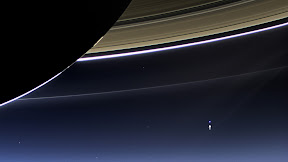
With the sun being blocked by Saturn, Cassini was able to capture the view of the planet and the inner solar system.  Actually a compilation of 141 images, the panoramic image shows a backlit Saturn as well as Mars, Venus and a pale blue Earth and our moon.

See the image below, click it for a larger view.  More on the image and Cassini’s mission below the photo.

On July 19, 2013, in an event celebrated the world over, NASA's Cassini spacecraft slipped into Saturn's shadow and turned to image the planet, seven of its moons, its inner rings -- and, in the background, our home planet, Earth.  Click the image for a larger view.  (NASA/JPL-Caltech/SSI)
On July 19, 2013, in an event celebrated the world over, NASA’s Cassini spacecraft slipped into Saturn’s shadow and turned to image the planet, seven of its moons, its inner rings — and, in the background, our home planet, Earth. Click the image for a larger view. (NASA/JPL-Caltech/SSI)

From NASA:

NASA has released a natural-color image of Saturn from space, the first in which Saturn, its moons and rings, and Earth, Venus and Mars, all are visible.

The new panoramic mosaic of the majestic Saturn system taken by NASA’s Cassini spacecraft, which shows the view as it would be seen by human eyes, was unveiled at the Newseum in Washington on Tuesday.

Cassini’s imaging team processed 141 wide-angle images to create the panorama. The image sweeps 404,880 miles (651,591 kilometers) across Saturn and its inner ring system, including all of Saturn’s rings out to the E ring, which is Saturn’s second outermost ring. For perspective, the distance between Earth and our moon would fit comfortably inside the span of the E ring.

“In this one magnificent view, Cassini has delivered to us a universe of marvels,” said Carolyn Porco, Cassini’s imaging team lead at the Space Science Institute in Boulder, Colo. “And it did so on a day people all over the world, in unison, smiled in celebration at the sheer joy of being alive on a pale blue dot.”

The mosaic is part of Cassini’s “Wave at Saturn” campaign, where on July 19, people for the first time had advance notice a spacecraft was taking their picture from planetary distances. NASA invited the public to celebrate by finding Saturn in their part of the sky, waving at the ringed planet and sharing pictures over the Internet.

An annotated version of the Saturn system mosaic labels points of interest. Earth is a bright blue dot to the lower right of Saturn. Venus is a bright dot to Saturn’s upper left. Mars also appears, as a faint red dot, above and to the left of Venus. Seven Saturnian moons are visible, including Enceladus on the left side of the image. Zooming into the image reveals the moon and the icy plume emanating from its south pole, supplying fine, powder-sized icy particles that make up the E ring.

The E ring shines like a halo around Saturn and the inner rings. Because it is so tenuous, it is best seen with light shining from behind it, when the tiny particles are outlined with light because of the phenomenon of diffraction. Scientists who focus on Saturn’s rings look for patterns in optical bonanzas like these. They use computers to increase dramatically the contrast of the images and change the color balance, for example, to see evidence for material tracing out the full orbits of the tiny moons Anthe and Methone for the first time.

“This mosaic provides a remarkable amount of high-quality data on Saturn’s diffuse rings, revealing all sorts of intriguing structures we are currently trying to understand,” said Matt Hedman, a Cassini participating scientist at the University of Idaho in Moscow. “The E ring in particular shows patterns that likely reflect disturbances from such diverse sources as sunlight and Enceladus’ gravity.”

Cassini does not attempt many images of Earth because the sun is so close to our planet that an unobstructed view would damage the spacecraft’s sensitive detectors. Cassini team members looked for an opportunity when the sun would slip behind Saturn from Cassini’s point of view. A good opportunity came on July 19, when Cassini was able to capture a picture of Earth and its moon, and this multi-image, backlit panorama of the Saturn system.

“With a long, intricate dance around the Saturn system, Cassini aims to study the Saturn system from as many angles as possible,” said Linda Spilker, Cassini project scientist based at NASA’s Jet Propulsion Laboratory in Pasadena, Calif. “Beyond showing us the beauty of the Ringed Planet, data like these also improve our understanding of the history of the faint rings around Saturn and the way disks around planets form — clues to how our own solar system formed around the sun.”

Launched in 1997, Cassini has explored the Saturn system for more than nine years. NASA plans to continue the mission through 2017, with the anticipation of many more images of Saturn, its rings and moons, as well as other scientific data.

The Cassini-Huygens mission is a cooperative project of NASA, the European Space Agency and the Italian Space Agency. JPL, a division of the California Institute of Technology, Pasadena, manages the mission for NASA’s Science Mission Directorate in Washington. JPL designed, developed and assembled the Cassini orbiter and its two onboard cameras. The imaging team is based at the Space Science Institute, Boulder, Colo.

Before and after: NASA satellite imagery reveals flood damage in Colorado

Colorado’s September 2013 floods have been absolutely devastating with over 1,500 homes destroyed and a death toll yet to be finalized. NASA satellites flew over the area near Greeley in recent days and the before and after pictures provide a stunning view from above of the devastation.

Using the ‘sliders’ on the two image sets below you can compare how the area looks normally versus how it looked in the days immediately after the flooding.

[wpw_ba_viewer width=”600″ height=”auto” anim_speed=”600″ start_percent=”0.5″ disable_intro=”false”]
[wpw_ba_img src=”http://lh6.googleusercontent.com/-EHZnr2QxwDo/UjxBTiFTICI/AAAAAAAAArY/lN8SZl9OGLs/s600/greeley-before.jpg” data_second=”http://lh3.googleusercontent.com/-Afkp7QnthD8/UjxBTnDEMrI/AAAAAAAAArU/QsAh-2SWRkw/s600/greeley-after.jpg” title=”Satellite imagery comparison of the area near Greeley, Colorado before and after the September 2013 flooding. (NASA EO)” data_info=”Satellite imagery comparison of the area near Greeley, Colorado before and after the September 2013 flooding. (NASA EO)”]
[/wpw_ba_viewer]Satellite Imagery of Flooding Near Greeley, Colorado – “Though water levels on the South Platte River were receding, muddy brown waters were still out of the river’s banks near Greeley, Colorado, on September 17, 2013, when the Operational Land Imager (OLI) on the Landsat 8 satellite acquired this image. At the time, the river was more than six feet above flood stage, down from more than eight feet above flood stage.” The before image was acquired on June 29, 2013 and shows the area as it normally appears. (NASA EO)


[wpw_ba_viewer width=”600″ height=”auto” anim_speed=”600″ start_percent=”0.5″ disable_intro=”false”]
[wpw_ba_img src=”http://lh4.googleusercontent.com/-4P17RwE0yJ4/UjxBUXq6AEI/AAAAAAAAArc/jf6eRTTMaeQ/s600/platte-before.jpg” data_second=”http://lh6.googleusercontent.com/-oFx1h0x653Y/UjxBTgBj2KI/AAAAAAAAArM/-rgcmbR2otk/s600/platte-after.jpg” title=”Satellite imagery comparison of the area near Greeley, Colorado before and after the September 2013 flooding. (NASA EO)” data_info=”Satellite imagery comparison of the area near Greeley, Colorado before and after the September 2013 flooding. (NASA EO)”]
[/wpw_ba_viewer]Infrared Satellite Imagery of Flooded South Platte River – “Intense rainfall in northern and eastern Colorado brought widespread, destructive flooding in mid-September 2013. Local citizens reported as much as 18 inches (46 centimeters) of rain from September 9 to 15, with some of the heaviest accumulation along the Front Range of the Rocky Mountains. A break in the precipitation allowed the Moderate Resolution Imaging Spectroradiometer (MODIS) on NASA’s Aqua satellite to acquire the top image of the floods on September 14. The second image, taken by Terra MODIS on September 7, 2013, shows the region before the rains began. The images were made from infrared light to increase the contrast between water and land.” (NASA EO)

Remembering 9/11: NASA imagery of fateful day serves as a reminder

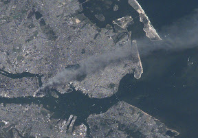
A zoomed in view of the World Trade Center site as seen by astronauts on board the International Space Station on September 11, 2001.  (NASA)  Click the image for a larger view.
A zoomed in view of the World Trade Center site as seen by astronauts on board the International Space Station on September 11, 2001. (NASA) Click the image for a larger view.

Twelve years ago today the United States of America was forever changed when war was brought to our own shores for the first time since Pearl Harbor.  The imagery of that day still burns vividly in our memories and one from NASA shows the devastation of that day as seen from 200 miles above.

On that fateful day, crewmembers of the Expedition Three crew of the International Space Station were circling the globe.

Commander Frank L. Culbertson, Soyuz Commander Vladimir Dezhurov and Flight Engineer Mikhail Tyurin surely felt helpless as they passed over Ground Zero and could clearly see the plume of smoke emanating from the spot where so many people lost their lives.

The image they captured on that day was stunning – see below.  While the World Trade Center was so far below, the devastation was so clear.

Our patriotism pulled us through those trying times and it shouldn’t take another attack to galvanize us in solidarity.

Today let us stand together to remember the victims of that horrible day.

Let us stand together and pay tribute to the lives of the thousands of men and women that have carried the battle forth since then and paid the ultimate sacrifice.

Let us stand together and honor the hundreds of thousands who wear our nation’s uniforms protecting us.

Let us never forget so that we and our children will never experience another day like 9/11.

NEVER FORGET!

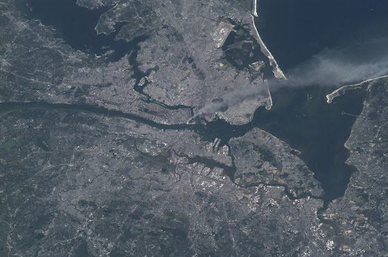
Visible from space, a smoke plume rises from the Manhattan area after two planes crashed into the towers of the World Trade Center. This photo was taken of metropolitan New York City (and other parts of New York as well as New Jersey) the morning of September 11, 2001.
Visible from space, a smoke plume rises from the Manhattan area after two planes crashed into the towers of the World Trade Center. This photo was taken of metropolitan New York City (and other parts of New York as well as New Jersey) the morning of September 11, 2001. “Our prayers and thoughts go out to all the people there, and everywhere else,” said Station Commander Frank Culbertson of Expedition 3, after the terrorists’ attacks. (NASA) Click the image for a larger view.

NASA’s Cassini sends back images of Earth from 900 million miles away

In this rare image taken on July 19, 2013, the wide-angle camera on NASA's Cassini spacecraft has captured Saturn's rings and our planet Earth and its moon in the same frame. (NASA/JPL-Caltech/Space Science Institute)
In this rare image taken on July 19, 2013, the wide-angle camera on NASA’s Cassini spacecraft has captured Saturn’s rings and our planet Earth and its moon in the same frame. Scroll down for a larger image or click to view the full size image. (NASA/JPL-Caltech/Space Science Institute)

Launched in 1997, NASA’s Cassini space probe arrived in Saturn orbit in 2004 and has provided valuable insight into the sixth planet in our solar system as well as others.  On July 19 of this year the spacecraft took an extraordinary image of our home planet and moon as seen from nearly 900 miles away.

The image captured the planet around which Cassini is orbiting, its infamous rings and off in the distance, the planet Earth and our moon.  The pale blue hue of our planet is almost unmistakable among the features in the photo.  It truly does make one feel small when compared to the immensity of the heavens above.

NASA’s press release says in part:

“In the Cassini images Earth and the moon appear as mere dots — Earth a pale blue and the moon a stark white, visible between Saturn’s rings. It was the first time Cassini’s highest-resolution camera captured Earth and its moon as two distinct objects.

“It also marked the first time people on Earth had advance notice their planet’s portrait was being taken from interplanetary distances. NASA invited the public to celebrate by finding Saturn in their part of the sky, waving at the ringed planet and sharing pictures over the Internet. More than 20,000 people around the world participated.

“”We can’t see individual continents or people in this portrait of Earth, but this pale blue dot is a succinct summary of who we were on July 19,” said Linda Spilker, Cassini project scientist, at NASA’s Jet Propulsion Laboratory in Pasadena, Calif. “Cassini’s picture reminds us how tiny our home planet is in the vastness of space, and also testifies to the ingenuity of the citizens of this tiny planet to send a robotic spacecraft so far away from home to study Saturn and take a look-back photo of Earth.”

“Pictures of Earth from the outer solar system are rare because from that distance, Earth appears very close to our sun. A camera’s sensitive detectors can be damaged by looking directly at the sun, just as a human being can damage his or her retina by doing the same. Cassini was able to take this image because the sun had temporarily moved behind Saturn from the spacecraft’s point of view and most of the light was blocked.”

In this rare image taken on July 19, 2013, the wide-angle camera on NASA's Cassini spacecraft has captured Saturn's rings and our planet Earth and its moon in the same frame. Click to view the full size image.  (NASA/JPL-Caltech/Space Science Institute)
In this rare image taken on July 19, 2013, the wide-angle camera on NASA’s Cassini spacecraft has captured Saturn’s rings and our planet Earth and its moon in the same frame. Click to view the full size image. (NASA/JPL-Caltech/Space Science Institute)

First images from new Landsat satellite capture northern Colorado Front Range

For four decades Landsat satellites have beamed back amazing pictures of the Earth from their perch far above the planet’s surface.  The latest craft in the series was launched last month and among the first images it captured were pictures of the area around Fort Collins and the Galena Fire burn scar.

The Landsat Data Continuity Mission took to space on February 11 to continue the joint program between NASA and the USGS.  This latest spacecraft has some of the highest resolution imagery devices of any Earth-observing satellite and will allow the agencies to monitor the natural and human processes taking place on the planet.

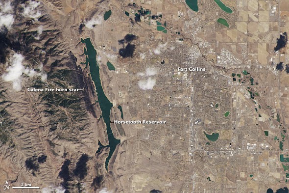
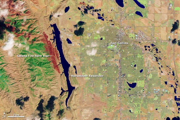
This week NASA released some of the first images from the new craft including its ‘Image of the Day’ from the Earth Observatory program on Thursday.  The photos capture the northern Colorado Front Range in natural color and one showing wavelengths of light not seen by the human eye.  The city of Fort Collins is clearly seen as is the Galena Fire burn scar west of Horsetooth Reservoir.

Below the images are further explanation from NASA.

landsat1.jpg
Made with reflected red, green, and blue light, the image from the Landsat Data Continuity Mission shows Fort Collins as the human eye would see it. (NASA)
landsat2.jpg
The image from the Landsat Data Continuity Mission shows the Fort Collins area in wavelengths of light not usually visible to people. Plants are green, city areas are purple, snow is pale blue, and bare earth is tan-pink. . (NASA)

From NASA:

On March 18, 2013, the newly launched Landsat Data Continuity Mission (LDCM) began to send back images of Earth from both of its instruments—the Operational Land Imager (OLI) and the Thermal Infrared Sensor (TIRS). This view of Fort Collins, Colorado, is among the satellite’s first images.

The images above are close-up views from the OLI sensor at its maximum resolution of 15 meters per pixel. The top image displays natural color, while the second image blends shortwave infrared, near-infrared, and green wavelengths (LDCM bands 7, 5, 3). The close-ups were cropped from larger Landsat scenes (downloadable beneath each web image) that show where the Great Plains meet the Front Range of the Rocky Mountains in Wyoming and Colorado.

“The first OLI and TIRS images look great right out of the box,” said Jim Irons, LDCM project scientist. “I have waited a long time to view the first LDCM images and I could not be more impressed with their appearance.”

Made with reflected red, green, and blue light, the top image shows Fort Collins as the human eye would see it. The city is a gray grid surrounded by the curving roads and brown yards of residential neighborhoods. White clouds cast black shadows on the ground below. Land freshly burned in the Galena fire is charcoal black—just slightly darker than the dark green coniferous forest to its west.

The second image shows Fort Collins in wavelengths of light not usually visible to people. Plants are green, city areas are purple, snow is pale blue, and bare earth is tan-pink. This combination of visible and infrared light reveals features of the landscape not otherwise visible. For example, irrigated parks, yards, and golf courses are bright green in this image, but brown in natural color. The Galena Fire burn scar is dark red and easy to distinguish from its surroundings.

The Landsat Data Continuity Mission was launched on February 11, 2013, to continue the four-decade-long Landsat record of Earth’s landscapes. LDCM represents an evolutionary advancement in technology from previous Landsat sensors, collecting more data daily and with greater fidelity. The imagers also include two new bands to improve the view of clouds and near-shore waters.

LDCM’s normal operations are scheduled to begin in late May 2013, after the instruments have been calibrated and the spacecraft has been fully checked out. At that time, NASA will hand over control of the satellite to the U.S. Geological Survey, and the satellite will be renamed Landsat 8.

Read more about LDCM and its imagery in the NASA story: A Closer Look at LDCM’s First Scene.


NASA satellite captures stunning imagery of a white landscape in aftermath of Colorado snowstorm

2013-02-26_130316.jpg
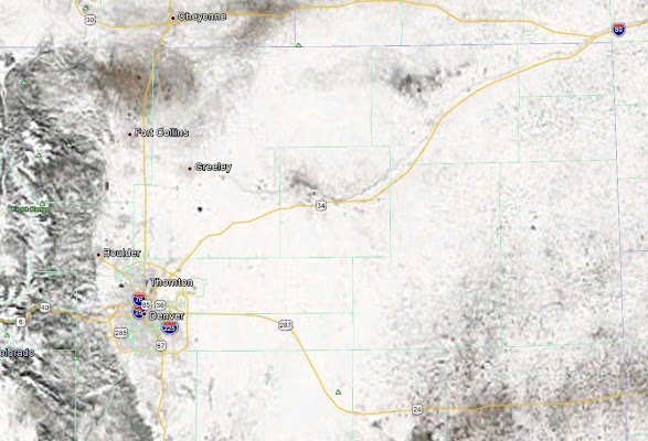
NASA satellite imagery shows the Colorado Front Range covered in snow following a snowstorm on Sunday, February 24, 2012.

Up until the past week satellite imagery of northeastern Colorado was relatively boring – and very brown.  In the wake of two storms, one of which was relatively significant, the image from the eyes in the sky changed considerably.

Sunday’s storm brought much-needed precipitation to the drought-stricken area.  Snowfall totals ranged from a high of nearly 27” near Pinecliffe west of Denver to 9.1” in the Mile High City and 6.9 inches in Thornton.

As the storm continued east on Monday it caused havoc on parts of Texas and Oklahoma where blizzard conditions brought that region to a standstill.

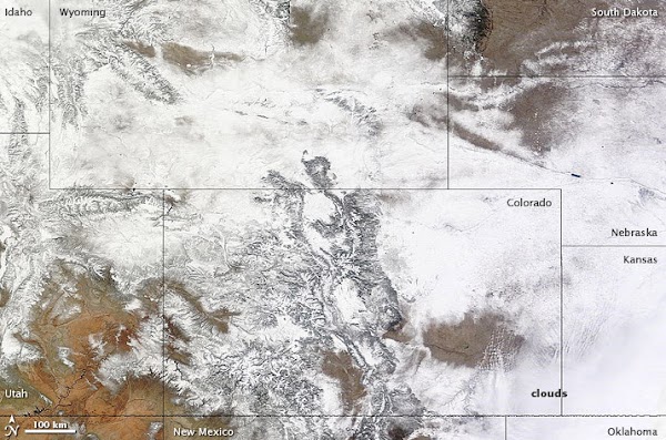
NASA’s Terra satellite flew over the Centennial State yesterday after skies had cleared and took pictures from 22,000 miles above.  The imagery clearly shows the snowy landscape of Colorado as well as parts of Utah, New Mexico, Kansas, Oklahoma, Nebraska and Wyoming.

2013-02-26_130344.jpg
NASA satellite imagery shows parts of nine states covered in snow following a snowstorm on Sunday, February 24, 2012.

From NASA:

Following on the heels of another storm, heavy snow fell on Colorado and neighboring states on February 24, 2013. On February 25, the Denver/Boulder Forecast Office of the National Weather Service reported preliminary snow totals from the area, including 27.2 inches (69.1 centimeters) west of Denver, and blizzard conditions east of the city. Like the previous storm, this one continued moving eastward.

The Moderate Resolution Imaging Spectroradiometer (MODIS) on NASA’s Terra satellite acquired this image on February 25, 2013. In the wake of the storms, snow extended across Colorado and Wyoming, and covered parts of Utah, New Mexico, and Nebraska. Although clouds had cleared in the west, cloud cover lingered in southeastern Colorado, western Kansas, and the Oklahoma Panhandle. The day after MODIS acquired this image, a new round of snow moved into the region.

References

  1. National Weather Service, Denver/Boulder, Colorado. (2013, February 25) Local storm report. National Oceanic and Atmospheric Administration. February 26, 2013.
  2. Sagliani, A. (2013, February 26) Snowstorm clogs Missouri, Illinois highways. AccuWeather.com. Accessed February 26, 2013.

NASA image courtesy LANCE MODIS Rapid Response. Caption by Michon Scott.

Instrument:

  • Terra – MODIS
midwestnight_vir_2013054.jpg
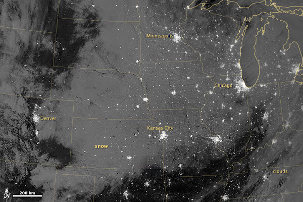
The Visible Infrared Imaging Radiometer Suite (VIIRS) on the Suomi NPP satellite captured this nighttime view at 1:55 a.m. Central Standard Time on February 23. (NASA)

 From NASA:

In late February 2013, a major snowstorm made its way across the continental United States, dropping snow from Colorado to the Great Lakes region. The National Weather Service reported snow totals of 5 to 8 inches (13 to 20 centimeters) in many parts of the Central Plains and Upper Mississippi River Valley. Some parts of the Central Plains experienced snowfall rates as high as 4 inches (10 centimeters) per hour, along with thundersnow.

The Visible Infrared Imaging Radiometer Suite (VIIRS) on the Suomi NPP satellite captured this nighttime view at 1:55 a.m. Central Standard Time on February 23. This imagery is from the VIIRS “day-night band,” which detects light in a range of wavelengths from green to near-infrared. The day-night band takes advantage of moonlight, airglow, and starlight to brighten the landscape and uses filtering techniques to observe signals such as city lights and snow cover. On the night of this image, the Moon was nearly full.

City lights glow like clusters of stars against a backdrop of grey and black in this image. The snow appears medium gray, and stretches from northern Texas to the Dakotas,and from the Rocky Mountain states eastward past Chicago. When VIIRS acquired this image, snow cover across multiple states had persisted since theprevious night.

References

  1. National Weather Service, La Crosse, Wisconsin. (2013, February 23) Winter Storm February 21–22, 2013. National Oceanic and Atmospheric Administration. February 25, 2013.

NASA Earth Observatory image by Jesse Allen and Robert Simmon, using VIIRS day-night band data from theSuomi National Polar-orbiting Partnership. Suomi NPP is the result of a partnership between NASA, the National Oceanic and Atmospheric Administration, and the Department of Defense. Caption by Michon Scott.

Instrument: 
Suomi NPP – VIIRS