Tag Archives: nasa

Meteor explodes over Russia with more energy than an atomic bomb, hundreds injured

2013-02-15_153151.jpg
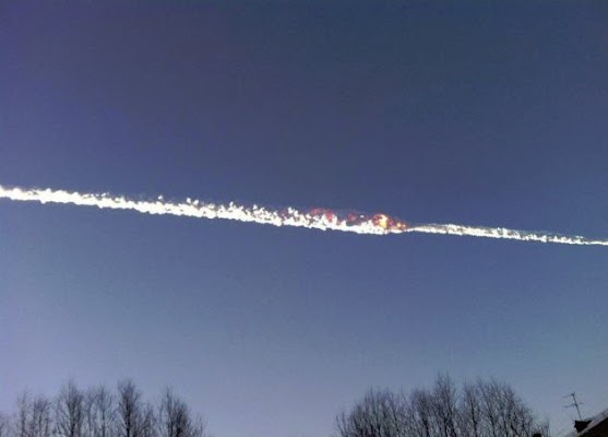
Flames from the explosion of the meteor were captured by Russians. (YouTube)

The Friday morning calm in Chelyabinsk, Russia was shattered by a meteor slamming into Earth’s atmosphere and exploding over the city in the Ural Mountains.  The energy released was greater than that of the first atomic bombs and caused widespread destruction and injuries.

  • Photo slideshow and video below

NASA says the 50 foot, 7,000 ton meteor entered the atmosphere at a speed of 40,000 mph and impacted at 9:20 a.m. local time (8:20 p.m. MST).

The energy released by the explosion has been estimated at 300 kilotons – far more than the 16 kiloton explosion of the bomb dropped on Hiroshima and 21 kilotons of the one dropped on Nagasaki.

The meteor lasted in the atmosphere for over 30 seconds before exploding approximately 15 miles above the planet.

Most of the fragments burnt up before reaching the ground however photos from the area did show a large, 20 foot wide hole in the ice on a nearby lake suspected to have been caused by a chunk of the rock.

The loud sonic boom and the resultant shockwave blew out windows in buildings across the area and is believed to have caused the collapse of a wall of an industrial building.

Russia media reports nearly 1,000 people reported injuries including 82 children, two of which are in intensive care.  No fatalities have been reported and no one is believed to have been hit by any fragments.

NASA said the meteor was not related to asteroid 2012 DA14 which passed extremely close to the earth today.  That asteroid is 150 feet across and came within 17,200 miles of the Earth.

More coverage:

Russian meteor photo slideshow

Video: Meteor explodes over Russia

Close call: Asteroid to pass between Earth and moon, manmade satellites

2013-02-10_164421.jpg
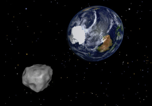
NASA depiction of asteroid 2012 DA14 as it passes by the Earth. (NASA)

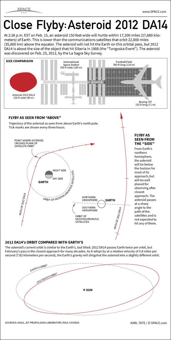
Known formally as ‘Asteroid 2012 DA14’, a massive piece of rock will pass perilously close to Earth on Friday.  The 150 foot wide asteroid is similar in size to one that devastated Siberia in the early 20th century.

At its closest to the Earth, asteroid 2012 DA14 will be within 17,200 miles of Earth.  That is much closer than the orbit of the moon (239,000 miles) and in fact will pass between Earth and many of our crucial communication satellites.

More than 100 geostationary satellites are perched in orbit at 22,000 miles.  While there is no danger of 2012 DA14 hitting the Earth, there is a very remote chance it could collide with one of these manmade satellites.

NASA says that the rock is will be speeding by at 17,400 miles per hour.  2012 DA14 will be at its closest point to earth on Friday, February 15 at approximately 12:24 p.m. MST.

The daytime pass for those in North America will preclude viewing here.  However those in Indonesia, Eastern Europe, Australia and Asia should be able to view it with a small telescope.

At 150 feet across, 2012 DA14 is similar in size to an asteroid that exploded over Siberia in 1908 – the “Tunguska Event.”  That object created a blast estimated at 1,000 times more powerful that the atomic bomb dropped on Hiroshima and flatted trees across an 800 square mile area.

Asteroids this size can cause extensive regional damage but are nowhere near the scale of the 5-mile-wide one that is thought responsible for wiping out the dinosaurs.

  • Watch: NASA video explaining asteroid 2012 DA14 below the inforgraphic

See how close asteroid 2012 DA14 will come to hitting the Earth, in this SPACE.com Infographic.
Source SPACE.com: All about our solar system, outer space and exploration

NASA Image of the Day captures powerful Nor’easter set to slam northeastern U.S.

Two powerful winter storms are set to collide over the northeastern United States today in what could be a record-breaking weather event.  Many locations including Boston and New York City will see blizzard conditions in what some are calling a potentially historic event.

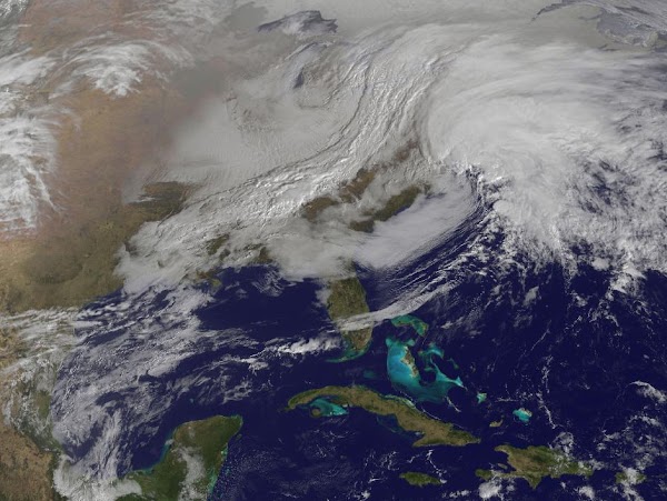
Parts of New England will be measuring snow in feet when this storm is finished and it is possible many locations will see their biggest snows on record.  NASA satellites captured an amazing image this morning of the region as the storms begin to arrive – see below.

NASA says, “The satellite image, captured at 9:01 a.m. EST, shows clouds associated with the western frontal system stretching from Canada through the Ohio and Tennessee valleys, into the Gulf of Mexico. The comma-shaped low pressure system located over the Atlantic, east of Virginia, is forecast to merge with the front and create a powerful nor’easter. The National Weather Service expects the merged storm to move northeast and drop between two to three feet of snow in parts of New England.”

Related:

2013-02-08_095942.jpg
A massive winter storm is coming together as two low pressure systems are merging over the U.S. East Coast. A satellite image from NOAA's GOES-13 satellite on Feb. 8 shows a western frontal system approaching the coastal low pressure area. (NASA) Click the image for a larger view.

NOAA and NASA: 2012 global temperatures rank in top 10 warmest on record

Following on the release of data showing the United States saw its hottest year on record, the nation’s agencies responsible for monitoring climate said this week that 2012 temperatures globally were similarly well above normal.

Using slightly different methodology, NASA and NOAA ranked global temperatures in 2012 as the 9th and 10th warmest on record respectively. The difference in ranking is considered irrelevant and has global warming alarmists touting the figures as proof of man’s impact on the Earth’s climate.

Read the rest of this story on Examiner.com and find out why many doubt claims like this.

This map represents global temperature anomalies averaged from 2008 through 2012. (NASA)
This map represents global temperature anomalies averaged from 2008 through 2012. (NASA) Click the image to view a slideshow of maps and data from the reports.

NASA satellite captures image of mid-winter dust storm in Colorado from space

When a cold front pushed through Colorado late last week not only did it bring bitter cold temperatures, it also brought a great deal of wind to the state’s southeastern plains.  NASA’s Aqua satellite was able to capture images of the ensuing dust storm as the cold front pushed through.

As wind speeds increased dust was thrown aloft in southeastern Colorado on Friday, January 11.  The intensity of the dust storm was undoubtedly aided by the dry landscape in what is the most parched part of the state.

Satellite imagery captured the dust storm as it moved into Kansas.

NASA writes:

Although the dust was thickest in western Kansas, many of the source points for the storm were in Colorado. One dust plume arose roughly 70 kilometers (40 miles) south of Colorado Springs. In Kansas, the eastern edge of the dust storm spanned 240 kilometers (150 miles) and the dust was thick enough to completely hide the land surface below, especially east of Goodland. Salina.com reported that the blowing dust reduced visibility to a quarter of a mile (0.4 kilometers).

The Moderate Resolution Imaging Spectroradiometer (MODIS) on NASA’s Aqua satellite captured this image of a dust storm in southeastern Colorado and western Kansas on January 11, 2013. (NASA)

NASA satellite imagery captures Colorado’s pre-Christmas snow

The wintry weather that moved through Colorado over the past 48 hours provided some relief to the drought-stricken state.  NASA satellites captured the snowy landscape of the Centennial State as the storm moved off toward the Midwest.

The system covered much of the higher elevations of the Rocky Mountain region in snowfall.  For Colorado this brought snow to the high country much to the delight of ski resorts and skiers.

In Denver the storm brought very cold temperatures but not as much snow as was hoped.  Officially the Mile High City recorded 1.7 inches bringing the seasonal total to 9.8 inches, well below normal.

The image from NASA’s Aqua satellite was taken on Wednesday, December 19 as the storm began to move out onto the plains.  The snow covered mountains west of Denver are clearly seen while cloud covers the lower elevations.

Satellite imagery shows the pre-Christmas snowstorm that blanketed Colorado. Click the image for a larger view.  (NASA)
Satellite imagery shows the pre-Christmas snowstorm that blanketed Colorado. Click the image for a larger view. (NASA)

NASA satellite offers up stunning view of the globe at night

A stunning nighttime view of North and South America, the west cost of Africa and Europe. (NASA) Click the image for a larger view.

The ‘blue marble’ images captured by NASA satellites are extremely popular and showcase the Earth without borders in its natural beauty.  New images dubbed ‘black marble’ show our planet at night with the lights of population dotting the landscape.

The Suomi National Polar-orbiting Partnership (Suomi NPP) satellite captured the images in April and October and were then stitched together to provide a cohesive, single view.  NASA created a matching video that shows the planet rotating as the nighttime lights rotate on it.

The imagery of the United States shows how much more densely populated the eastern half of the nation is versus the western half.  A look at Colorado shows the main population centers of the Colorado Front Range along I-25 and the many smaller communities that dot the plains and mountains.

See below for some of the stunning views and to view an animation of the Earth rotating.

The night view of the contiguous United States clearly shows where the major population centers are and highlights the more sparsely populated west. (NASA) Click the image for a larger view.
Nighttime satellite imagery of Colorado clearly shows the population centers of the Front Range. (NASA)
Nighttime satellite imagery of Colorado clearly shows the population centers of the Front Range. (NASA) Click the image for a larger view.
A zoomed in view of the Colorado Front Range and the area from Colorado Springs, through Denver and on to Cheyenne, WY. (NASA)

From NASA:

The night side of our planet twinkles with light, and the first thing to stand out is the cities. “Nothing tells us more about the spread of humans across the Earth than city lights,” asserts Chris Elvidge, a NOAA scientist who has studied them for 20 years.

This new global view and animation of Earth’s city lights is a composite assembled from data acquired by the Suomi National Polar-orbiting Partnership (Suomi NPP) satellite. The data was acquired over nine days in April 2012 and thirteen days in October 2012. It took satellite 312 orbits and 2.5 terabytes of data to get a clear shot of every parcel of Earth’s land surface and islands. This new data was then mapped over existing Blue Marble imagery to provide a realistic view of the planet.

To view the video of the night lights, click on the link below the image or visit our YouTube page. To view many more still images and maps of night lights, visit our new feature page: Earth at Night 2012.

The view was made possible by the “day-night band” of Suomi NPP’s Visible Infrared Imaging Radiometer Suite. VIIRS detects light in a range of wavelengths from green to near-infrared and uses “smart” light sensors to observe dim signals such as city lights, auroras, wildfires, and reflected moonlight. This low-light sensor can distinguish night lights tens to hundreds of times better than previous satellites.

Named for meteorology pioneer Verner Suomi, the polar-orbiting satellite flies over any given point on Earth’s surface twice each day at roughly 1:30 a.m. and 1:30 p.m. Suomi NPP orbits 824 kilometers (512 miles) above the surface as it circles the planet 14 times a day. Data is sent once per orbit to a ground station in Svalbard, Norway, and continuously to local direct broadcast users around the world. The mission is managed by NASA with operational support from NOAA and its Joint Polar Satellite System, which manages the satellite’s ground system.

Learn more about the VIIRS day-night band and nighttime imaging of Earth in our new feature story: Out of the Blue and Into the Black.

NASA Earth Observatory image and animation by Robert Simmon, using Suomi NPP VIIRS data provided courtesy of Chris Elvidge (NOAA National Geophysical Data Center). Suomi NPP is the result of a partnership between NASA, NOAA, and the Department of Defense. Caption by Mike Carlowicz.

Instrument: 

Suomi NPP – VIIRS

Remembering a national hero: NASA releases Neil Armstrong tribute video

It is fitting that Neil Armstrong's footprint will forever be on the moon just as the man remains in a nation's heart. (NASA)

There are few Americans who don’t know the name ‘Neil Armstrong’ and can’t cite the tremendous contribution the man made to exploration and our nation.  Following his passing last week, a memorial service was held today at the Washington National Cathedral and a new video tells much about the man.

On July 16, 1969, Neil Armstrong, Buzz Aldrin and Michael Collins took to the skies aboard their massive Saturn V rocket bound for the moon.  Five days later, Armstrong and Aldrin would lift the spirits of the nation and the imaginations of the world as they became the first men to walk on the moon.

Chosen because he was a civilian at the time, Armstrong would make that infamous ‘small step for [a] man, one giant leap for mankind’.  In doing so, the United States Navy veteran would forever be mentioned in the history books with the likes of Columbus, Polo, Lewis & Clark, Cook and Hillary.

We mourn the loss of this national hero but thank the Lord for a man who gave so much to his country.  As we wrote last week, “May he rest in peace and may one day our nation find the will to continue on the path which he and so many of his predecessors put us on.”

Rest in peace, Neil.

NASA image: Spacewalking astronaut ‘touches the sun’

While they are viewed by the public these days as routine, there can hardly be a more dangerous – or thrilling – task for an astronaut to perform than a spacewalk.  The imagery captured by these modern day explorers is nothing short of amazing as seen in a photo of NASA astronaut Sunita Williams seemingly touching the sun during a spacewalk last week.

During an extravehicular activity (EVA) aboard the International Space Station, Williams and Japan Aerospace Exploration Agency astronaut Aki Hoshide performed much-needed maintenance and repairs to the orbiting platform.  During the six-hour, 28-minute spacewalk Hoshide captured an image of Williams appearing to reach for the sun at one point during the EVA.

NASA astronaut Sunita Williams, Expedition 32 flight engineer, appears to touch the bright sun during the mission’s third session of extravehicular activity (EVA) on Sept. 5, 2012.  (NASA)
NASA astronaut Sunita Williams, Expedition 32 flight engineer, appears to touch the bright sun during the mission’s third session of extravehicular activity (EVA) on Sept. 5, 2012. (NASA) Click the image for a larger view.