In 1995 with the opening of Denver International Airport, the National Weather Service moved the Mile High City’s official weather station to the new facility. This location, 12 miles from the old Stapleton site, oftentimes sees far different weather than what the majority of people in the Denver area see and it is reflected in our weather records.
We have long said that any claims of a weather record having been set since 1995 should include an asterisk, noting that the comparison is to the old locations and thus not really valid. Those 12 miles make a world of difference.
In the latest example of how our climate records are being altered, Denver supposedly set five all-time record high temperatures this summer. The reality? Not one of those days would have been record-setting had the station not been moved.
Retired National Weather Service meteorologist Dave Larison has long railed against the move of the weather station. In a recent letter to the editor in the Denver Post, he called out the media hype and the National Weather Service for the invalid comparisons. It is shared here with his permission.
Denver’s recent heat wave wasn’t really record-breaking and here’s why
Denver Post Opinion, August 21, 2024
Re: “100-degree sizzlers here to stay as summers get hotter,” Aug. 11 news story
Any discussion of Denver weather records must include the fact that the official recording site was moved to Denver International Airport (DIA) when it opened in 1995. This location has a different microclimate than the previous site of Stapleton Airport, situated 12 miles to the southwest of DIA. Before Stapleton, weather records were taken in downtown Denver dating back to 1872.
On Sunday, Aug. 4, the daily record high of 102 set at DIA would not have been a record at Denver Central Park (Stapleton) where the daily high was 96. In fact, none of the five daily record highs set at DIA this summer would have been records at the previous Denver sites. DIA has reached 100 degrees on six days in 2024, while the highest temperature recorded at Central Park has been 99.
With all the media hype of human-made climate change and record heat, we need to be careful not to compare apples and oranges with weather stats going out to the world representing Denver. Average annual precipitation also tends to run a bit lower at DIA, and snowfall is quite often less at the airport due to its proximity farther away from the mountains.
— Dave Larison, Longmont
— Editor’s note: Larison is a retired National Weather Service meteorologist
RELATED: Two airports, two different climates. Read the series:
ThorntonWeather.com’s owner and operator used to write for a now-defunct website called Examiner. This was a national site but with locally focused content. As the Denver Weather Examiner, Tony covered a number of topics related to Denver and Colorado weather.
Among them, he was always quick to point out how Denver’s weather records were being skewed by the move of Denver’s official weather station to Denver International Airport. In 2009, he wrote a three-part series explaining why this was an issue and why it mattered.
Fifteen years later, this continues to be a problem and thus we are re-publishing the series here. While the data is not current and some of the images were lost with time, readers can still understand and appreciate the problem.
Part 3: Does it matter if Denver weather and climate records are skewed? Originally published March 5, 2009, Examiner.
Fourteen years ago Denver opened its new airport and the National Weather Service followed suit and moved Denver’s weather monitoring system 12 miles east further onto the plains. Since then, weather enthusiasts and meteorologists have said Denver’s climate records were forever being altered inappropriately.
Monday we provided some background on the history of Denver’s weather monitoring and records. Yesterday we took a look at empirical data that shows that the weather at DIA does not accurately reflect the weather in town where people actually live and showed why it isn’t fair to compare data from the last 14 years to measurements taken in the previous 124. Today we explain why all this matters and talk to the National Weather Service to see what they have to say about the problem.
Does it matter?
Public policy decisions are made based on accurate measurements of our environment and the weather. Consider the debate over global warming or something on a smaller scale closer to home, water management decisions. Living in a semi-arid environment like we do in Colorado, much depends on water- from Colorado’s largest industry of agriculture to how much water you have for your lawn in the summer. If measurements taken at DIA claim an abnormally dry or wet year, governments and the public make decisions based on them. But are those decisions accurate and are they based on valid data?
I spoke to Byron Lewis, Program Manager at the National Weather Service Office in Boulder, and he stated that he felt the comparison of historical records between those taken at DIA and Stapleton should not matter – he says it is no different than when Denver’s official station moved from downtown to Stapleton in 1950. He also felt that the issue of accuracy between precipitation and snow measurements was not noteworthy.
Others see it differently. They point to the fact that the move from downtown to Stapleton was 6 miles – half the distance of the move from Stapleton to DIA. Further, they argue that the area where DIA resides in a much more ‘plains’ type climate and does not accurately reflect Denver weather.
One retired NWS meteorologist told me, “It is climatologically absurd for the NWS to mix the 1872-1994 Denver city records with DIA weather data for the purposes of normals, record extremes, and top ten lists. Many in the public and science community can recognize this fallacy–and it’s making the Weather Service look foolish.”
The Solution
The National Weather Service does at least partially recognize the problem and seems to have acknowledged that the weather at DIA is not what most folks experience within Denver. Mr. Lewis said that next month they hope to begin installing a new monitoring station in Denver City Park. This new station will provide more accurate measurements closer to where people actually live. However, there is a catch – official Denver records and measurements will continue to be taken at DIA.
There is nothing to prevent the National Weather Service from moving the official measuring site back to Stapleton or some other more central location. One local news station has a statement on their website claiming that, “because commercial airports are the origin of regular weather observations in the United States. This is mandated by the National Weather Service and the Federal Aviation Administration.” This is absolutely untrue.
While weather stations must be maintained at major airports for obvious reasons, cities do not need to use those specific stations for their official measurements. In fact, the United States’ two largest cities – New York and Los Angeles – both take official weather measurements in different locations than their airport. New York measures its weather in Central Park and Los Angeles takes its measurements downtown.
It is this weather enthusiast’s opinion that by throwing yet another location into the mix, the water simply gets muddled further. As long as Denver’s “official” weather measurements are taken at DIA, any records should either come with an asterisk denoting that they aren’t comparable to historical records or they should only be based on data collected in the last 14 years.
Unless and until a move is made, we just have to remember to take any announcement of a weather record with a grain of salt.
Two airports, two different climates. Read the series:
ThorntonWeather.com’s owner and operator used to write for a now-defunct website called Examiner. This was a national site but with locally focused content. As the Denver Weather Examiner, Tony covered a number of topics related to Denver and Colorado weather.
Among them, he was always quick to point out how Denver’s weather records were being skewed by the move of Denver’s official weather station to Denver International Airport. In 2009, he wrote a three-part series explaining why this was an issue and why it mattered.
Fifteen years later, this continues to be a problem and thus we are re-publishing the series here. While the data is not current and some of the images were lost with time, readers can still understand and appreciate the problem.
Part 2: Data shows Denver weather records skewed by move to DIA Originally published March 3, 2009, Examiner.
Did you hear February was Denver’s least snowiest month? Or was it? As we discussed yesterday, a growing chorus of voices are objecting to the National Weather Service’s use of measurements at Denver International Airport for official Denver weather record keeping. They claim that comparing data from DIA to previous records compiled for more than 40 years at Stapleton and more than 75 years before that in downtown isn’t a fair analysis.
In this second of a three part series, we take a look at some of the data to see just how big of a difference the 12 mile move from Stapleton to DIA made. We also investigate potential issues with accuracy at the automated monitoring station at DIA that could forever be altering our climate records. Tomorrow we will take a look at why all of this matters and why you should care.
Temperatures
An analysis shows that in just the last eight years DIA registers warmer high temperatures and cooler low temperatures than stations closer to downtown and in areas where people actually live. For our comparison, we compared the last eight years of data for Denver International Airport versus the measurements taken at Buckley Air Force Base. We chose Buckley because that is the closest official measuring station to the location of the old Stapleton International Airport.
<insert table>
As you can see, the differences between where measurements have been taken for the last 14 years at DIA and where they were taken previously is significant. DIA’s highest recorded temperatures each year averages nearly 2 degrees more than those closer to Denver. Similarly, the station’s low temperatures are more than 2 degrees cooler. This essentially throws any record high or record low temperatures that were recorded in the last 14 years out the window. Any comparison of today’s data with historical records taken at Stapleton are invalid because the location move to DIA has clearly impacted the measurements.
Precipitation
This is probably the single most astonishing statistic and helps to show just how much of a difference 12 miles can make. The National Weather Service has been taking precipitation measurements at both DIA and at the former Stapleton site so we can do a direct comparison between the two sites. The results are astonishing.
<insert table>
The chart clearly shows that precipitation measurements at DIA consistently underperform as compared to those at Stapleton. Over the 8 year period, DIA on average measures 13% less precipitation than Stapleton.
One year in particular stands out. In 2002 Colorado was in a drought by any measurement. At the end of the year the National Weather Service proclaimed it as Denver’s driest on record. However, that claim was based on measurements at DIA. If you use the measurements at Stapleton – where weather records were kept for more than 40 years – the claim doesn’t stand up to scrutiny. Stapleton’s 8.49 inches of precipitation in 2002, while certainly a dry, below normal year, would actually make it only the 6th driest year. It can easily be argued that the claim that 2002 was Denver’s driest year should be discarded.
As a more recent example, March 2008 was proclaimed the “third driest March on record” when a mere 0.17 inch of precipitation was recorded at DIA. However, 0.55 inch was recorded at Stapleton, an amount which would not put the month anywhere near the top 10 driest.
Snowfall
Historical snowfall measurement comparisons between the two locations unfortunately cannot be directly performed as it was only this year that the National Weather Service began measuring snow at DIA. However, we can infer from the precipitation measurements noted above that there will be a comparable discrepancy in snowfall measurements as well. This stands to reason as the plains receive less snow than areas closer to the mountains and going 12 miles east can make a big difference.
Issues of accuracy?
The precipitation and snowfall issue gets even further convoluted this year with the move to measuring snowfall at DIA. While this would seem to solve the problem of inconsistency between taking precipitation measurements at DIA but snowfall at Stapleton, it turns out things aren’t quite that easy.
Weather enthusiasts have noticed problems with recent snowfall and precipitation measurements. Just recently on Monday, January 12th, when a small snow storm moved through the Front Range the National Weather Service recorded 3 inches of snowfall but only 0.03 inch precipitation.
On average snow has a 10:1 moisture content which means that 1 inch of snow equals 0.1 inch of moisture. Using the standard, approximately 0.3 inch precipitation should have been recorded – 10 times what was actually reported.
Extending the observation period out to include the two month period from December 1, 2008 to January 31, 2009, similar problems have occurred. At Stapleton, where measurements are taken manually, 12 inches of snowfall was recorded with a moisture content of 1.08 inches – approximately an 11:1 ratio and one that could be expected. By contrast, DIA – using automated precipitation measurements – recorded 15 inches of snow but a meager 0.37 inch of precipitation. That is an unfeasibly dry 40:1 snow to precipitation ratio.
Detractors abhor the use of automated stations for such important climate records and are quick to point out that this is but one of many examples of inconsistent measurements. One former NWS employee said, “the NWS sold their soul to automation years ago” and as a result we are stuck with inaccurate records.
Two airports, two different climates. Read the series:
ThorntonWeather.com’s owner and operator used to write for a now-defunct website called Examiner. This was a national site but with locally focused content. As the Denver Weather Examiner, Tony covered a number of topics related to Denver and Colorado weather.
Among them, he was always quick to point out how Denver’s weather records were being skewed by the move of Denver’s official weather station to Denver International Airport. In 2009, he wrote a three-part series explaining why this was an issue and why it mattered.
Fifteen years later, this continues to be a problem and thus we are re-publishing the series here. While the data is not current and some of the images were lost with time, readers can still understand and appreciate the problem.
Part 1: Do Denver weather and climate records have an asterisk attached? Originally published March 2, 2009, Examiner.
February 2009 is Denver’s least snowiest February on record. A new record high temperature is recorded on January 21, 2009. Record low temperatures are recorded on December 14th and 15th of last year.
These announcements are common and we all take notice when we hear them and they make for great water cooler chat topics but are these claims accurate?
In 1995 Denver finally opened its new airport out on the plains east of the city. This new facility, 12 miles as the crow flies northeast of the old Stapleton International Airport, moved the airport from an urban environment to a rural one and more than 19 miles from the center of Denver. Following that move, the National Weather Service (NWS) began taking some of its official measurements at the glistening new airport. In doing so, some say Denver’s climate records have forever been altered and as such any weather record should have an asterisk attached to it.
Official Denver weather statistics were collected from the NWS’ downtown Denver office from November, 1871 to December 1949. In January 1950 observations were moved to Stapleton International Airport where they remained until February 1995. From March 1995 forward, Denver’s official weather has been measured at DIA. With the move, precipitation switched to Automated Surface Observing Systems (ASOS), an automated means of making the measurement. In a somewhat confusing twist, the measuring of snowfall remained at Stapleton until just this snow season.
The question many are asking – Does a move of 12 miles make that much of a difference when measuring the weather? Twelve miles is the same distance as between downtown and Golden, or downtown and Centennial or downtown and the northern edge of Thornton. How often do we hear about heavy snow falling at I-25 and C-470 and yet downtown remains dry? If you live in any of the outer metro area suburbs you know that what the news stations report as the weather downtown rarely is what you experience.
Twelve miles, particularly in a topographically and geographically diverse area as the Front Range would appear to make a world of difference. That is why when you watch the evening news local meteorologists include the conditions at their local station downtown in addition to the official data at DIA. Most local meteorologists have railed against the move and are quick to point out that the weather as measured at DIA does not reflect what Denver weather truly is.
When new records are announced, detractors point out that it isn’t fair to compare the data compiled at DIA with that which was recorded previously at Stapleton or downtown. Just yesterday the National Weather Service announced that February 2009 was the least snowiest on record. But was it really? The NWS says Denver received only a trace of snow (less than 0.1 inch) but this was at DIA. The vast majority of the metro area had at least some measurable snow during the month and Stapleton, where official records were kept for more than 40 years, had 0.8 inch of snow – a number that would push it well out of ‘least snowiest’ contention. Many say we are comparing apples and oranges.
Empirical data shows that every meaningful statistic has been skewed by the move to DIA. In this three part series we will take a look at how moving Denver’s official weather measurements to DIA have skewed Denver’s climate records and why it matters to you. Tomorrow we take a look at the empirical data showing just how big of a difference 12 miles makes. Wednesday we’ll tell you why it matters and learn about some possible solutions to the problem.
Stay tuned!
Two airports, two different climates. Read the series:
We all know our Pi Day storm last week was a big one.
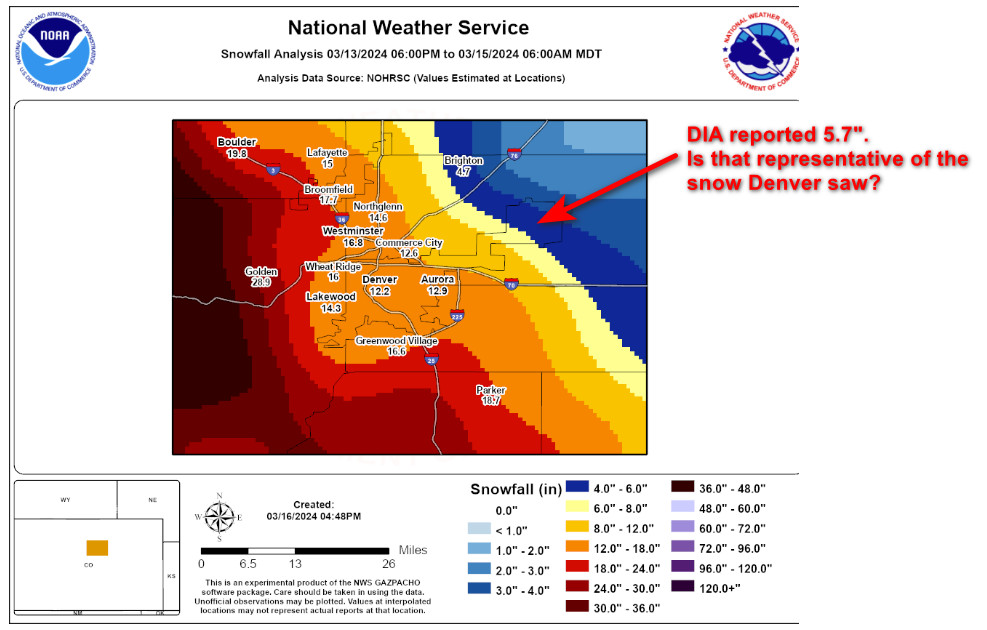
Here in Thornton we recorded 10.8 inches. Downtown Denver reported 12.2 inches.
What will Denver’s official snow records show? A mere 5.7 inches. This is a direct result of the National Weather Service’s insistence on having Denver’s official measurements taken at Denver International Airport.
Data was collected in downtown Denver from 1872 through December 1948, then at the Stapleton Airport Office from January 1950 through February 1995. In March 1995, the service made the station at DIA the city’s official station for most meteorological observations. In 2008, they began taking official snowfall measurements out there.
Being so far from the Mile High City’s population center, the data collected there is entirely unrepresentative of what residents experience. Further, the move has skewed our climate records rendering comparisons to historical data invalid. It is highly frustrating and is a significant issue which the National Weather Service dismisses.
Local television meteorologists have long railed against the change in station, most notably Mike Nelson of Denver 7. With this storm, Ashton Altieri of CBS 4 called the National Weather Service out on it.
This snowfall analysis across the Denver area from our good friends at @NWSBoulder proves (again!) why the rule about big cities having to officially measure precipitation at their airport is completely bogus.
Downtown: 12.2 inches last week
DIA: 5.7 inches last week pic.twitter.com/IOzP5iYNba
Today’s message from the NWS highlights the importance of having a proper emergency kit in your vehicle and should the worst-case scenario occur where you get stuck, what you should do to survive.
PUBLIC INFORMATION STATEMENT
NATIONAL WEATHER SERVICE GRAND JUNCTION CO
601 AM MDT MON OCT 17 2022
Winter Travel Safety
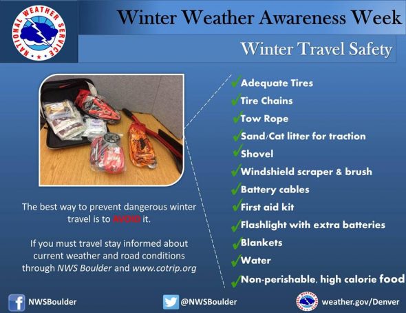
Winter Weather Preparedness Week continues through Saturday October 23rd. Preparedness is a big part of this campaign. Before winter weather arrives in earnest, it is highly recommended that you prepare your car or truck for winter travel. This includes a winter survival kit and good snow tires.
Before winter weather arrives in earnest, it is highly recommended that you prepare your car or truck for winter travel.
A well-equipped vehicle has adequate tires, tire chains, tow rope, sand or cat litter for traction, shovel, tool kit, windshield scraper and brush, battery cables, first aid kit, flashlight, extra batteries, blankets and/or sleeping bags, extra clothing, candles, waterproof matches, jug of water, high calorie packaged food for quick energy, and an empty can to melt snow for drinking.
And during winter weather events, the best way to prevent treacherous winter travel is to avoid it. This can be done by staying informed about current weather and road conditions as well as the latest weather forecasts. Information on road conditions in Colorado is available on the web at www.cotrip.org or from the toll free number 1-877-315-7623. When calling from anywhere in Colorado, dialing 511 will also access the Colorado road reports. Additionally, a free smartphone application, CDOT Mobile, is available.
If you should become stranded during a winter storm, stay with your vehicle and do not panic. If accompanied by others, take turns sleeping. Run the motor every hour for about ten minutes to maintain warmth, but keep windows open a little to prevent the buildup of carbon monoxide. Make sure the exhaust pipe is not blocked. Keep the car visible with brightly colored cloths tied to the side view mirrors, door handles, or external antenna. At night, turn on the dome light when running the engine. Exercise periodically by vigorously moving arms, legs, toes and fingers.
In the mountains, avalanches become a possibility in the winter, especially below steep slopes. Avalanches occasionally come down across roads, with little or no warning. However, avalanche control work is performed on many avalanche prone roads in Colorado, making the roads safer to travel. Caution is advised when traveling along avalanche prone roads, especially during and shortly after a heavy snowstorm, as well as during periods of rapid snowmelt.
Very strong downslope winds occur at times mainly along the front range of Colorado. These Chinook and Bora winds can have gusts exceeding 100 mph. Persons planning travel in lightweight or high-profile vehicles should avoid travel during these strong wind events especially on north-south oriented roads.
Roads which appear to be clear in the wintertime may actually be coated with a thin layer of ice, commonly known as black ice. This nearly invisible ice layer can cause you to rapidly lose control of your vehicle. Black ice is most common during the nighttime hours. If you detect black ice you should reduce your speed.
Please follow these winter travel safety recommendations which could save your life.
Winter weather in Colorado can be an inconvenience but more than that it can be deadly. Emergency preparedness for major winter storms – as well as for other types of severe weather – is an important part of living in a state where conditions can change wildly from one moment to the next.
To help raise awareness of the need to be prepared for these occasions, the week of October 16th to October 22nd has been proclaimed Winter Weather Preparedness Week in Colorado.
The National Weather Service will be issuing Public Information Statements each day this week to highlight the dangers of winter weather and how best to be prepared. ThorntonWeather.com will be posting these important messages here to help you be prepared. Please take the time to read and heed these messages – your life and the lives of your loved ones could depend on it.
Stay up to date with Thornton’s weather: ‘Like’ us on Facebook and follow us on Twitter.
From the National Weather Service:
PUBLIC INFORMATION STATEMENT
NATIONAL WEATHER SERVICE BOULDER CO
600 AM MDT SUN OCT 16 2022
..Winter Weather Preparedness Week in Colorado…
The week of October 16th through October 22nd is Winter Weather Preparedness Week in Colorado. This is an excellent time for all individuals, families, businesses, schools, and media outlets to review their winter storm preparedness plans. It is especially important for all new arrivals to the state to become familiar with the National Weather Service watch and warning definitions, as well as winter safety procedures.
Snow in Colorado is important to the farmers, the ski areas, and for filling up reservoirs. However, winter storms often bring heavy snow, bitter cold air, high winds, low visibilities and slick roads. This can lead to dangerous travel conditions and other life threatening situations such as avalanches and very frigid wind chill temperatures.
To help you prepare for these hazards this coming winter, the National Weather Service will issue statements throughout the week to discuss:
Wildfires are not strictly a weather-related threat. The weather does however play a significant role in starting fires and in the ability of firefighters to battle them.
From the National Weather Service:
PUBLIC INFORMATION STATEMENT
NATIONAL WEATHER SERVICE GRAND JUNCTION CO
500 PM MDT SAT JUNE 26 2021
Colorado Lightning Safety Week concludes today…with wildfires being the final topic.
During the past week we have presented lightning information and safety rules. Although wildfires are not an actual weather phenomenon…wildfires are directly related to lightning and other weather elements.
Normally…the wildfire threat in Colorado increases significantly after the middle of June and usually peaks in early July…and remains high through august and early September. Colorado averages about 2500 wildfires each year.
About half of all forest fires in Colorado are ignited by lightning. Additionally…many rangeland and wheat field fires are caused by lightning. Many of these lightning caused wildfires occur in the absence of rain and are the result of what is referred to as dry thunderstorms.
Lightning is often accompanied by strong winds from thunderstorms. These winds can quickly turn smoldering organic material into a raging fire. Thunderstorm winds tend to be erratic in direction and speed…posing one of the greatest dangers for firefighters.
Lightning that strikes the ground is usually divided into two categories…negative and positive strikes… Depending on the ionic source region of the thunderstorm. The negative strikes are far more common than positive strikes. The positive strikes are more intense and have a longer duration than the negative strikes and are more likely to ignite a fire. Lightning detection technology provides land managers and weather forecasters with the ability to identify the general location and charge category of each lightning strike.
National Weather Service forecasters help land managers and firefighters by producing fire weather zone forecasts on a daily basis. Spot fire weather forecasts are also provided for those who work on prescribed burns or specific wildfires. Forecasters also issue red flag warnings for use by land managers when the combination of dry vegetation and critical weather conditions will result in a high potential for the development and spread of
Wildfires. Land managers…in turn… Typically inform the general public of the fire danger in national parks…forests… And other public lands.
During periods of extreme fire danger in forests and rangelands…
You should avoid being in areas where you might become trapped by a wildfire.
You should avoid the use of matches or anything else which could ignite a fire.
Make sure that hot parts of motorized equipment…such as mufflers…are not allowed to come in contact with dry grasses or other potentially flammable material.
If you become trapped or cut off by a wildfire seek shelter in areas with little or no fuel…such as rock slide areas or lakes.
For more information on wildfires and fire safety…please check out the following web addresses…
Knowing what to do when lightning strikes someone is critical to helping them survive. As with many serious injuries, immediate action must be taken. After the event, lightning strike victims oftentimes face a number of health and mental challenges.
From the National Weather Service:
PUBLIC INFORMATION STATEMENT
NATIONAL WEATHER SERVICE BOULDER CO
600 AM MDT FRI Jun 25 2021
Colorado Lightning Safety Awareness Week continues through tomorrow. Today we discuss lightning medical issues for survivors.
The facts about lightning strike victims:
In Colorado, nearly a half million cloud-to-ground lightning flashes are documented each year. With millions of visitors and extensive outdoor activities, it is not surprising that, each year on average, three people are killed by lightning in the state of Colorado while 13 are injured. Last year, two people were killed by lightning in the Centennial State while seven were injured.
While any lightning fatality is tragic, injuries caused by lightning can be devastating to both the victim and the family. For those who have a family member or relative that suffers a significant disability from lightning, life changes forever. In addition to the physical pain and mental anguish suffered by the victim and their family, the incident may lead to a loss of income for all involved as medical expenses can drain the family’s financial resources.
If someone is struck by lightning, it is critically important that they receive the appropriate medical attention immediately. Some deaths can be prevented if the victims are attended to promptly. Lightning victims do not carry an electrical charge and are safe to handle. First, check to see that the victim is breathing and has a pulse, and start cardio-pulmonary resuscitation, if needed. Then have someone dial 911. If possible, move the victim to a safer place. Do not let the rescuers become lightning victims. Lightning can strike the same place twice.
Lightning strike victims may face many mental challenges that they will have to live with for the rest of their lives. When the brain is affected by a lightning strike, the person often has difficulty with many of the mental processes that most people take for granted. The person may suffer from short-term memory loss, and may have difficulty remembering new information and accessing old information. Victims may often find it very difficult to carry on more than one task at a time, and may be easily distracted. Their personality may change and they may become easily irritated.
Lightning strike victims often become easily fatigued and may become exhausted after only a few hours of work. This may be because mental tasks that were once automatic may now require intense concentration to accomplish. Although some victims may sleep excessively at first, after a few weeks many find it difficult to sleep more than two or three hours at a time.
Another common long-term problem for survivors is pain.
Medically, pain is difficult to quantify. Lightning strike victims often suffer irreparable nerve damage that causes intense pain that affects the ability to function. Many survivors complain of chronic headaches, some of which are very intense and debilitating.
Lightning Strike and Electric Shock Survivors International is a support group for individuals and families that are struggling with life after a lightning injury. Helpful information is available at their web address: www.lightning-strike.org
In addition, NOAA’s lightning website contains abundant information on lightning safety and can be found at: www.lightningsafety.noaa.gov
Lightning information specific for the State of Colorado can be found at: www.weather.gov/pub/lightning
The lightning topic for tomorrow will be lightning caused fires.
Certainly the dangers of lightning are most prevalent outdoors and being indoors is the safest place to be when thunder is heard. Even inside your home or business lightning can be damaging and cause significant injury.
From the National Weather Service:
PUBLIC INFORMATION STATEMENT
NATIONAL WEATHER SERVICE GOODLAND KS
600 AM MDT THU JUN 24 2021
Statistics tell us that we are much less likely to become a lightning strike victim if we are inside a substantial structure such as a home or office building. In 2016, thirty eight people in the United States were killed by lightning, and all of these fatalities occurred outdoors. While nearly all people who are injured or killed by lightning were outdoors, a small percentage of people are injured by lightning while indoors. Therefore, it is important to discuss lightning safety while indoors.
The dangerous electrical current associated with a lightning strike typically enters a structure through wires, cables or pipes that connect to the building from the outside. Lightning can also directly enter into a structure through an open window, door or garage door. Once in a structure, the dangerous current can travel through the electrical, phone, cable and plumbing systems and through metal wires or bars in concrete walls or flooring.
Corded electronic devices are the leading cause of indoor lightning injuries in the United States. These include personal computer keyboards, game consoles, and corded phones. Other injuries have occurred when people were close by to televisions which connect to an outside cable or satellite system. Open windows, doors and garage doors allow for a direct strike to enter a home, so make sure all windows and doors are closed when lightning is occurring. Never watch a lightning storm from a porch or open garage door. There are several You-Tube videos that show people being injured by lightning while they were recording lightning from their porch or open garage door.
It is very important to stay away from any plumbing when lightning is occurring outside. This includes sinks, bathtubs and showers. When lightning is occurring, do not hand wash dishes, do not give kids a bath, and do not take a shower. It is best to wait to do laundry until after the storm goes by as washers and dryers are connected to both the electrical and plumbing systems.
People have also been injured while leaning and standing near concrete in their homes and offices. This is due to metal rebar which is in the concrete, and this metal acts as a conductor when lightning hits the building.
A house or other substantial building offers the best protection from lightning. In contrast, many small shelters such as bullpens, picnic shelters, sheds or tents (no matter what the size) offer no protection from lightning, and should be avoided at all cost.
Here is a summary of lightning safety tips for inside the home:
1. Avoid corded electronics and electrical equipment.
2. Avoid contact with plumbing, such as taking a shower, bathing, hand washing dishes or doing laundry.
3. Stay away from windows, doors, garages and porches.
4. Do not lie on concrete floors or lean against concrete walls.
5. If a substantial building is not nearby, an enclosed car or truck offers excellent protection from lightning.
Below are a couple of web sites that contain additional lightning information:
NOAA’s lightning website which contains abundant information on lightning safety can be found at: www.lightningsafety.noaa.gov
Lightning information specific for the State of Colorado can be found at: www.weather.gov/pub/lightning
The lightning topic for tomorrow will be lightning medical issues for survivors.