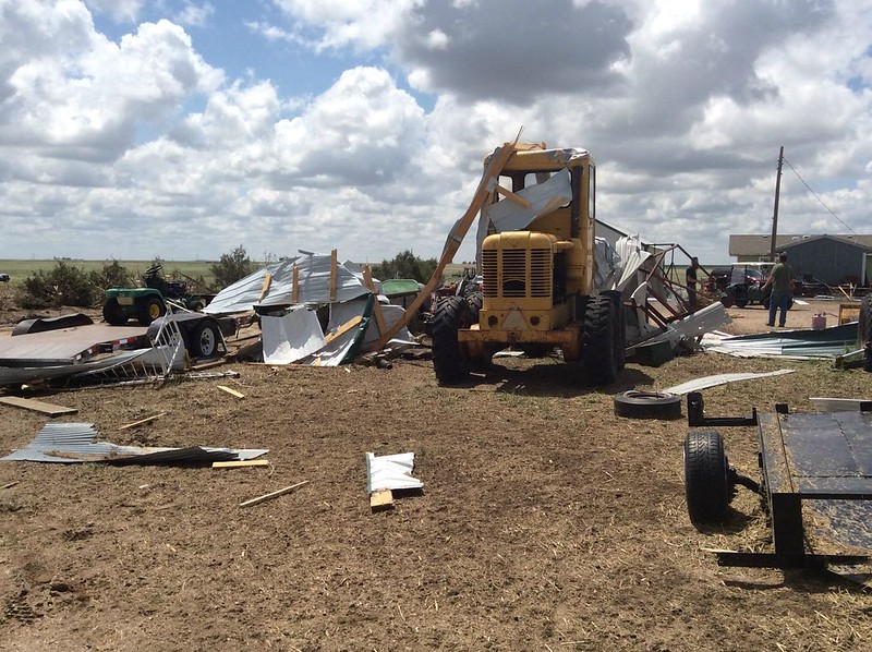
The thunder rolled across eastern Colorado on Tuesday, May 24 – as did hail, wind and tornadoes. Washington County saw the most intense activity with multiple twisters including one damaging tornado that has been rated an EF-1.
The National Weather Service sent survey teams to the area to evaluate the damage inflicted by Mother Nature.
They found two tornadoes of relatively weak EF-0 strength occurred near Akron. Neither any caused damage.
Near Platner though, a more powerful tornado ripped through a farm at about 6:50pm that evening. The twister lifted a pole barn, destroying it. Debris was found one mile away.
Wind and hail ripped across an area six miles wide near Akron causing extensive damage. Farm equipment was toppled and a barn heavily damaged by the wind while houses saw the siding punctured and windows broken from hail.
Below are images taken by the National Weather Service of the area.
| [flickr_set id=”72157668536532282″] |
Public Information Statement
National Weather Service Denver/Boulder CO
1056 AM MDT THU MAY 26 2016

...NWS DAMAGE SURVEY FOR 05/24/16 TORNADO EVENT...

.OVERVIEW...A long-lived supercell thunderstorm moved across
eastern Colorado and produced two EF-1 tornadoes and two EF-0
tornadoes in Washington County on May 24, 2016. Widespread wind
and hail damage also occurred, with a swath of damage nearly 6
miles wide at some points east and northeast of Akron.

.Washington County tornado near Platner...

Rating:                 EF-1
Estimated peak wind:    86-110 mph
Path length /Statute/:  0.9 miles
Path width /Maximum/:   20 yards
Fatalities:             0
Injuries:               0

Start date:             May 24 2016
Start time:             650 PM MDT
Start location:         1 mile northeast of Platner / Washington County / CO
Start Lat/Lon:          40.1647 / -103.0467

End date:               May 24 2016
End time:               655 PM MDT
End location:           1 mile east of Platner / Washington County / CO
End_lat/lon:            40.155 / -103.0366

This tornado struck one farm, lofting and completely destroying
a pole shed, and also damaging trees. Power lines were snapped
just to the southeast of the farm.

.Washington County tornado near Yuma County line...

Rating:                 EF-1
Estimated peak wind:    110 mph
Path length /Statute/:  0.1 mile
Path width /Maximum/:   90 yards
Fatalities:             0
Injuries:               0

Start date:             May 24 2016
Start time:             715 PM MDT
Start location:         9 miles north/northwest of Yuma / Washington County / CO
Start Lat/Lon:          40.2350 / -102.7943

End date:               May 24 2016
End time:               716 PM MDT
End location:           9 miles north/northwest of Yuma / Washington County / CO
End_lat/lon:            40.2348 / -102.7936

This tornado struck one farm, destroying a pole shed. Slight roof damage
occurred to the house, along with some tree damage.

.Washington County tornado 1 mile Northeast of Akron...

Rating:                 EF-0
Estimated peak wind:    65-85 mph
Path length /Statute/:  0.0 miles
Path width /Maximum/:   10 yards
Fatalities:             0
Injuries:               0

Start date:             May 24 2016
Start time:             644 PM MDT
Start location:         1 mile southeast of Akron / Washington County / CO
Start Lat/Lon:          40.1490 / -103.1981

End date:               May 24 2016
End time:               644 PM MDT
End location:           1 mile southeast of Akron / Washington County / CO
End_lat/lon:            40.1490 / -103.1981

Brief touchdown with no damage.

.Washington County tornado 1 mile Southeast of Akron...

Rating:                 EF-0
Estimated peak wind:    65-85 mph
Path length /Statute/:  0.0 miles
Path width /Maximum/:   10 yards
Fatalities:             0
Injuries:               0

Start date:             May 24 2016
Start time:             647 PM MDT
Start location:         1 mile northeast of Akron / Washington County / CO
Start Lat/Lon:          40.1708 / -103.1959

End date:               May 24 2016
End time:               647 PM MDT
End location:           1 mile northeast of Akron / Washington County / CO
End_lat/lon:            40.1708 / -103.1959

Brief touchdown with no damage.

EF Scale: The Enhanced Fujita Scale Classifies
Tornadoes into the following categories.

EF0...Weak...... 65 to 85 mph
EF1...Weak...... 86 to 110 mph
EF2...Strong.... 111 to 135 mph
EF3...Strong.... 136 to 165 mph
EF4...Violent... 166 To 200 mph
EF5...Violent... >200 mph*

NOTE:
The information in this statement is PRELIMINARY and subject to
change pending final review of the events and publication in
NWS Storm Data.
