Tag Archives: radar

Denver weather radar to receive upgrade to latest technology

Denver's radar at Front Range Airport is receiving a major upgrade that will greatly enhance weather monitoring capability. (ThorntonWeather.com)

The National Weather Service has begun a significant upgrade to Denver’s weather radar.  The new dual-polarization (dual-pol) radar brings 14 new data types and will greatly enhance the ability of forecasters to monitor and analyze storms.

During the upgrade while Denver’s radar is inoperative, ThorntonWeather.com’s radar page will be using the adjacent radar in Cheyenne.  This will somewhat limit the ability to monitor storms during the two week period while the work is taking place.

The information below is from the National Weather Service and describes the dual-pol upgrade and what it brings to the table in terms of enhancements with monitoring severe weather.

From the National Weather Service:

During a two-week period, beginning August 30, 2012, the Doppler radar at your National Weather Service Forecast Office will undergo an upgrade to incorporate new technology. For these two weeks, radar data will be unavailable from NWS Denver/Boulder! 


This much anticipated upgrade is part of the NWS vision to build a Weather-Ready Nation to better protect lives and livelihoods. This exciting upgrade will incorporate a new technology called dual-polarization, or dual-pol. This new technology will result in 14 new radar products that will enable us to continue providing our suite of high quality products and services to the public. This new technology and data will primarily help forecasters identify the type of precipitation that is falling as well as improve rainfall estimates

Why Upgrade to Dual-Pol?
Current NWS Doppler radars transmit and receive pulses of radio waves in a horizontal orientation. As a result, the radar only measures the horizontal dimensions of targets (e.g. cloud and precipitation droplets). Dual-polarimetric radar transmits and receives pulses in both a horizontal and vertical orientation. Therefore, the radar measures both the horizontal and vertical dimensions of targets. Since the radar receives energy from horizontal and vertical pulses, we can obtain better estimates of the size, shape, and variety of targets. It is expected that this will result in significant improvements in the estimation of precipitation rates, the ability to discriminate between precipitation types (e.g. hail vs. rain), and the identification of non-meteorological returns, such as chaff, ground clutter, and smoke plumes from wildfires that are not uncommonly detected by weather radar systems such as WSR-88D.
Current NWS Doppler Radar
Dual-Pol Radar
The Benefits of Dual-Pol
  • Better estimation of total precipitation amounts
  • Better estimation of the size distribution of hydrometeors (raindrops, snowflakes, hailstones, drizzle)
  • Much improved ability to identify areas of extremely heavy rainfall that are closely linked with flash floods
  • Improved detection and mitigation of non-weather related radar echoes (chaff, smoke plumes, ground clutter)
  • Easier identification of the melting layer (helpful for identifying snow levels in higher terrain)
  • Improved ability to classify precipitation type

The full benefit of dual-pol radar, however, will not be fully realized until NWS forecasters and research meteorologists develop real-time expertise.

What is Polarization?
A radio wave is a set of oscillating electric and magnetic fields, oriented 90 degrees to each other. Polarization of the wave is the direction, or orientation, of the electric field.

Horizontal Polarization

Horizontal Polarization Graph The electric field is oriented horizontally, along the x-axis (blue). The magnetic field is oriented vertically along the y-axis (white).
Vertical Polarization
Vertical Polarization Graph The electric field is oriented vertically, along the y-axis (orange). The magnetic field is oriented horizontally along the x-axis (white).
Want to Learn More?

ThorntonWeather.com enhances radar system and satellite imagery

ThorntonWeather.com's new satellite imagery allows a close in, bird's eye view of the weather.

For more than four years ThorntonWeather.com has been the one and only source for truly local weather for Thornton, Colorado.  We are continually improving the site to provide more information and now we have greatly enhanced two of our most popular features.

First up and arguably the most exciting is the satellite imagery.  Using imagery provided by NOAA you begin by selecting a region – northeastern Colorado for a look close to home or perhaps a look at the entire United States.  Once you go there, you are given an animated display powered by Adobe Flash. 

Best of all with the new satellite system is a series of overlays that you can select using the boxes above the satellite image.  You can add the county outlines, major highways, and even weather conditions (the selections vary depending on the region).  For each region you can also select an enhancement.  These different color palettes are useful for spotting wildfires, the most significant areas of a storm and more.

You can access the satellite imagery by going to Radar & Maps on the menu on the left then select “Satellite Imagery.”

Last but not least is a revamped radar display system.  The radar is now fully animated like the new satellite which gives you much greater control.  You can speed up the animation, slow it down and pause the display, all of which are useful to seeing where the weather is headed.  You can even zoom in on a spot on the display. 

ThorntonWeather.com Super Doppler RadarTo access the radar go to Radar & Maps on the menu on the left and select “TW Super Doppler Radar.”

These are but two of a number of features added in recent months.  Be sure to check out our website change log for all the details.  For all the latest you can also follow us on Twitter and join us on Facebook.

Take a look and if you have any comments, questions or ideas for future enhancements to the site leave them below or contact us.

Lots of new features including ski reports, live traffic conditions and more

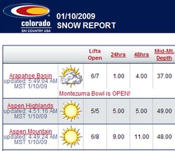
Ski condition reports are just one of the many new features recently added to ThorntonWeather.com.

ThorntonWeather.com is just like the Colorado weather – we are constantly changing!  In recent weeks we have added a number of features that we are sure everyone will appreciate from ski condition reports to Denver traffic conditions to national radar and maps.  Some of the new additions include:

  • Added the Colorado Ski Conditions from Colorado Ski Country USA.  It is available under the Live Conditions menu on the left. 
  • Modified the Weather Maps page to start off showing the approaching systems (vice radar).  Also changed the selection menu at the bottom of the page to show regional information on top.
  • Added a National Maps page and menu item under the Radar & Maps menu. 
  • Added a Colorado Road Conditions page with current state highway conditions from CDOT.  Available from the Live Condtions menu on the left.
  • Added a live Denver traffic map from Traffic.com.  Available from the Live Condtions menu on the left.
  • Added a number of national weather maps from the Weather Channel.  These are available under the Radar & Maps menu on the left and include:

For a complete log of site changes, you can view our Website Change Log here.

Do you have a suggestion for something you would like to see us add?  Do you have any other comments, questions or criticisms?  Use the comment feature below and let us know what you think!