Tag Archives: rain

June 2009 is now the 2nd wettest Denver June

From the National Weather Service: June 2009 has moved into the second wettest June since Denver weather records began in 1872.  So far for June 2009, through June 26th, the Denver International Airport (DIA) has measured 4.86 inches of liquid (and there are still 4 more days left in June).  The 4.86 inches of water is 3.52 inches above normal through the 26th.  Last year, June 2008 had only measured 0.73 inch again through the same June time frame.

The wettest June on record for Denver was in June 1882 when 4.96 inches of moisture was collected in the rain bucket.

For the 2009 year so far, 10.38 inches of water has been measured at DIA which is a very impressive 2.51 inches above the normal through June 26th.   Last year in June, only 3.04 inches had been recorded through the same time frame.

Note:  The average Denver annual precipitation is 15.81 inches.

As always, we have to ask, do Denver weather and climate records have an asterisk attached?  Read our Examiner.com investigation to see why maybe they should.

Saturday storms bring heavy rain, funnel cloud

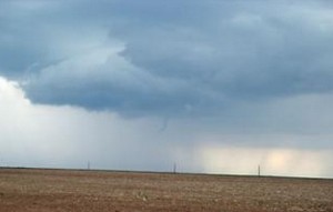
This funnel cloud was over north central Aurora Saturday afternoon.  Photo was taken from the Bennett area.
This funnel cloud was over north central Aurora Saturday afternoon. Photo was taken from the Bennett area.

Saturday afternoon’s thunderstorms brought some pretty interesting weather to Denver and the Front Range.  Our wettest and cloudiest month seems to be intent on finishing out right on par with what we would expect this time of year. 

Thunderstorms and showers moved across the metro area in the late afternoon Saturday producing thunder, lightning and rain across much of the area.  Some stations on the Rocky Mountain Weather Network reported quite heavy rain, particularly those on the west side of town.  Some of the rain totals along the Front Range since yesterday:

In yesterday’s forecast we warned of the possibility of landspouts which are small, short-lived tornadoes.  None were observed however a funnel cloud was reported over north central Aurora about three miles south of DIA at 4:50pm.  The funnel lasted about two minutes and never touched down and did not cause any damage.

Crazy August weather – Lots of moisture but overall still behind the curve

If August 2008’s weather thus far had to be summed up in one word it would be WET!  Last Thursday a low pressure system began moving into the region from Saskatchewan, Canada.  Ahead of the system a cold front moved into northeastern Colorado and by Friday that low pressure had settled over Colorado. 

Over a three day period through Sunday morning, this produced lots of rain and record cool temperatures.  As it stands today in fact, August 2008 has climbed to # 3 on the all-time wettest August’s on record – and we still have 12 days left in the month. 

Denver’s top 5 wettest Augusts

5.85″   1979
4.47 ”  1951
4.03″   2008  (4.76″ recorded in Thornton)
3.87″   1923
3.69″   1991

While our August moisture has been great, it has not erased the deficit in precipitation overall for 2008.  Up until this month, we had nine straight months with below average precipitation.  Through the end of August, Denver historically averages 12.07 inches of precipitation.  As of today, even with our record setting August, we only have recorded 7.31 inches in 2008.  Certainly the recent storm highlights that we could easily catch up with one or two wet systems moving through but it does also serve as a reminder that we are still quite dry. 

Record temperatures too!  With the wet cold front came record setting cool temperatures too.  Friday, August 15th, Denver reached 59 degrees which demolished the previous record low maximum temperature of 68 degrees set in 1880.  Saturday, August 16th we reached 58 degrees which again broke the previous record low maximum for the date of 63 degrees set in 1890.  ThorntonWeather.com recorded 58 and 57.2 on August 15th and 16th respectively.

Signs of Fall approaching as cool and wet hit Thornton

Updated Saturday, 8/16/08 @ 5:19am – Denver officially reached a high temperature of 59 degrees on Friday (Thornton reached 58).  This crushed the old record low maximum temperature of 68 degrees set in 1880.  Saturday has the potential to do the same with a forecast high of 56.

Updated Friday, 8/15/08 @ 2:25pm – A Flood Watch has been issued by the National Weather Service effective immediately through Sunday morning.  As always, keep up to date with our real time advisories and our NOAA All Hazards Radio system.

—————-

From a record setting heatwave just a couple of weeks ago to cool and wet and possibly record setting temperatures at the other end of the spectrum too!  Colorado is nothing if not inconsistent!  🙂

A closed low has developed over much of Colorado and temperatures have dropped considerably and rain has fallen over much of the Front Range.  Rain showers and isolated thunderstorms will dominate the weather Friday as will cool temperatures.  Friday’s forecast high of 62 degrees is in fact 24 degrees below normal for this date.  If that forecast holds true, we could set a record for the lowest high temperature for the date as well – the previous record is 69 degrees set in 1933!  The same holds true for Saturday as well with a forecast high the same as Friday and the lowest high temperature on record of 68 degrees set way back in 1874. 

The rain brings much needed moisture to the Front Range but it will be slow in falling and shouldn’t pose much in the way of flooding problems.  As of this writing, the Rocky Mountain Weather Network is showing pretty consistent precipitation across the metro area with 0.29″ having fallen at ThorntonWeather.com so far.  The moisture will be on and off through Saturday night and then begin decreasing Sunday and into Monday. 

It looks like the first part of next week we will return to more seasonal weather and temperatures into the 80’s.