Two powerful winter storms are set to collide over the northeastern United States today in what could be a record-breaking weather event. Many locations including Boston and New York City will see blizzard conditions in what some are calling a potentially historic event.
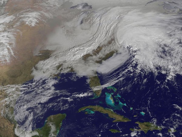
Parts of New England will be measuring snow in feet when this storm is finished and it is possible many locations will see their biggest snows on record. NASA satellites captured an amazing image this morning of the region as the storms begin to arrive – see below.
NASA says, “The satellite image, captured at 9:01 a.m. EST, shows clouds associated with the western frontal system stretching from Canada through the Ohio and Tennessee valleys, into the Gulf of Mexico. The comma-shaped low pressure system located over the Atlantic, east of Virginia, is forecast to merge with the front and create a powerful nor’easter. The National Weather Service expects the merged storm to move northeast and drop between two to three feet of snow in parts of New England.”
When a cold front pushed through Colorado late last week not only did it bring bitter cold temperatures, it also brought a great deal of wind to the state’s southeastern plains. NASA’s Aqua satellite was able to capture images of the ensuing dust storm as the cold front pushed through.
As wind speeds increased dust was thrown aloft in southeastern Colorado on Friday, January 11. The intensity of the dust storm was undoubtedly aided by the dry landscape in what is the most parched part of the state.
Satellite imagery captured the dust storm as it moved into Kansas.
NASA writes:
Although the dust was thickest in western Kansas, many of the source points for the storm were in Colorado. One dust plume arose roughly 70 kilometers (40 miles) south of Colorado Springs. In Kansas, the eastern edge of the dust storm spanned 240 kilometers (150 miles) and the dust was thick enough to completely hide the land surface below, especially east of Goodland. Salina.com reported that the blowing dust reduced visibility to a quarter of a mile (0.4 kilometers).
The wintry weather that moved through Colorado over the past 48 hours provided some relief to the drought-stricken state. NASA satellites captured the snowy landscape of the Centennial State as the storm moved off toward the Midwest.
The system covered much of the higher elevations of the Rocky Mountain region in snowfall. For Colorado this brought snow to the high country much to the delight of ski resorts and skiers.
In Denver the storm brought very cold temperatures but not as much snow as was hoped. Officially the Mile High City recorded 1.7 inches bringing the seasonal total to 9.8 inches, well below normal.
The image from NASA’s Aqua satellite was taken on Wednesday, December 19 as the storm began to move out onto the plains. The snow covered mountains west of Denver are clearly seen while cloud covers the lower elevations.
The ‘blue marble’ images captured by NASA satellites are extremely popular and showcase the Earth without borders in its natural beauty. New images dubbed ‘black marble’ show our planet at night with the lights of population dotting the landscape.
The Suomi National Polar-orbiting Partnership (Suomi NPP) satellite captured the images in April and October and were then stitched together to provide a cohesive, single view. NASA created a matching video that shows the planet rotating as the nighttime lights rotate on it.
The imagery of the United States shows how much more densely populated the eastern half of the nation is versus the western half. A look at Colorado shows the main population centers of the Colorado Front Range along I-25 and the many smaller communities that dot the plains and mountains.
See below for some of the stunning views and to view an animation of the Earth rotating.
From NASA:
The night side of our planet twinkles with light, and the first thing to stand out is the cities. “Nothing tells us more about the spread of humans across the Earth than city lights,” asserts Chris Elvidge, a NOAA scientist who has studied them for 20 years.
This new global view and animation of Earth’s city lights is a composite assembled from data acquired by the Suomi National Polar-orbiting Partnership (Suomi NPP) satellite. The data was acquired over nine days in April 2012 and thirteen days in October 2012. It took satellite 312 orbits and 2.5 terabytes of data to get a clear shot of every parcel of Earth’s land surface and islands. This new data was then mapped over existing Blue Marble imagery to provide a realistic view of the planet.
To view the video of the night lights, click on the link below the image or visit our YouTube page. To view many more still images and maps of night lights, visit our new feature page: Earth at Night 2012.
The view was made possible by the “day-night band” of Suomi NPP’s Visible Infrared Imaging Radiometer Suite. VIIRS detects light in a range of wavelengths from green to near-infrared and uses “smart” light sensors to observe dim signals such as city lights, auroras, wildfires, and reflected moonlight. This low-light sensor can distinguish night lights tens to hundreds of times better than previous satellites.
Named for meteorology pioneer Verner Suomi, the polar-orbiting satellite flies over any given point on Earth’s surface twice each day at roughly 1:30 a.m. and 1:30 p.m. Suomi NPP orbits 824 kilometers (512 miles) above the surface as it circles the planet 14 times a day. Data is sent once per orbit to a ground station in Svalbard, Norway, and continuously to local direct broadcast users around the world. The mission is managed by NASA with operational support from NOAA and its Joint Polar Satellite System, which manages the satellite’s ground system.
NASA Earth Observatory image and animation by Robert Simmon, using Suomi NPP VIIRS data provided courtesy of Chris Elvidge (NOAA National Geophysical Data Center). Suomi NPP is the result of a partnership between NASA, NOAA, and the Department of Defense. Caption by Mike Carlowicz.
The Waldo Canyon Fire near Colorado Springs became a raging inferno and one of the most disastrous in Colorado history. New satellite imagery released by NASA shows the massive area burned by the blaze and provides perspective as to just how close it came to the state’s second largest city.
Officials are hoping to announce 100% containment of the fire later today. The blaze has burned 18,247 acres, the 11th largest in Colorado history. More notably however the blaze claimed two lives and destroyed 346 homes making it the most destructive wildfire in the state’s history.
NASA’s Terra satellite flew over the burn area on July 4th and false color imaging provides a clear view of the burn area of the fire. One can easily see where the fire entered the Mountain Shadows neighborhood and how close it came to the Air Force Academy and more populous areas of Colorado Springs.
The Waldo Canyon Fire was first reported on June 23, 2012, burning in Pike National Forest, three miles (5 kilometers) west of Colorado Springs. Fueled by extremely dry conditions and strong winds, it had burned 18,247 acres (74 square kilometers) by July 5. The blaze severely damaged or destroyed 346 homes, making it the most destructive fire in Colorado history. Mountain Shadows, a neighborhood northwest of the Colorado Springs city center, experienced some of the most severe damage. According to an analysis conducted by the Denver Post, the combined value of the homes that burned to the ground in the neighborhood was at least $110 million.
The Advanced Spaceborne Thermal Emission and Reflection Radiometer (ASTER) on the Terra satellite acquired this view of the burn scar on July 4, 2012, when the fire was still burning but was 90 percent contained. Vegetation-covered land is red in the false-color image, which includes both visible and infrared light. Patches of unburned forest are bright red, in contrast with areas where flecks of light brown indicate some burning. The darkest brown areas are the most severely burned. Buildings, roads, and other developed areas appear light gray and white. The bright red patches of vegetation near Colorado Springs are golf courses, parks, or other irrigated land.
In only a week the Waldo Canyon Fire has scorched 17,000 acres and destroyed nearly 350 homes near Colorado Springs, Colorado. While thousands of residents remain evacuated, Google and DigitalGlobe have released satellite imagery providing a bird’s eye view of the devastation. Read the rest of this story on Examiner.com. Be sure to check out the stunning before and after photos in the slideshow.
Colorado’s deadly and destructive wildfire season continues with as many as a dozen blazes burning in recent days. Smoke from the fires has blanketed parts of the state in recent weeks and new NASA satellite imagery shows the smoke plumes from some of the blazes. Read the rest of this story and view the images on Examiner.com.
Satellite imagery released by the USGS and NASA (below) shows the scar the EF3 tornado left on the earth as it ripped a path 39 miles long. The image taken by Landsat shows the path of the half-mile wide tornado as it cut through Sturbridge and beyond.
The twister first touched down near Westfield and then moved into Springfield after crossing the Connecticut River. Both areas saw extensive damage to buildings and homes as the twister moved through.
As it moved east the tornado debarked trees and struck the town of Monson where extensive damage was seen. It eventually hit Brimfield Sate Forest and then the Southbridge Airport.
When it was done, four people were killed and 200 injured. Latest estimates put the damage cost at $90 million making it the most costly natural disaster in the state’s history.
Two smaller, EF1 rated tornadoes also struck nearby on the same day. One caused a damage path 3.6 miles long and the other 1.3 miles long.
National parks are some of the nation’s most valuable and beautiful areas. Colorado is home to four of them and NASA satellites recently captured images of what may become our next one.
Colorado National Monument sits southwest of Grand Junction and contains extraordinarily beautiful and rugged terrain. In 1907, John Otto wrote of the area saying, “I came here last year and found these canyons, and they feel like the heart of the world to me. I’m going to stay and build trails and promote this place, because it should be a national park.”
Otto would not see his dream realized. Instead, in 1911, President William Howard Taft established the Colorado National Monument through a Presidential Proclamation.
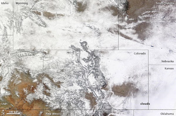
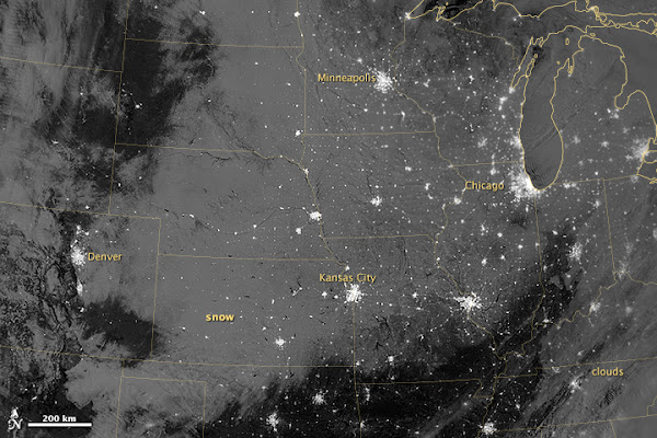
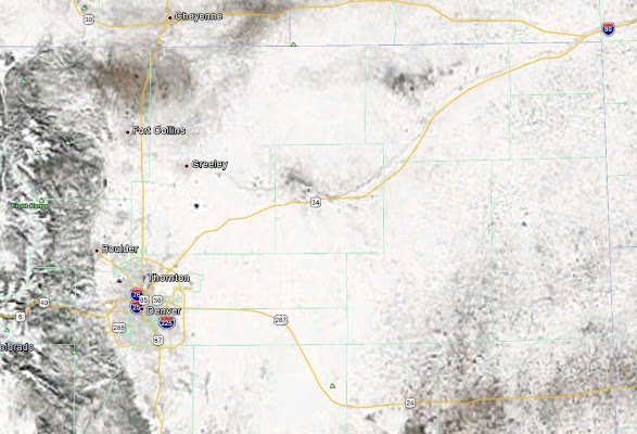
The recent snowstorm covered not only Thornton but the vast majority of Colorado in a blanket of white. The latest satellite imagery from NASA shows the extent of the snow stretching across the state from border to border.
The satellite image, taken by NASA’s Aqua satellite on February 10th, shows the impressive snowfall received by the entire region. Not only is Colorado covered but the neighboring states of Wyoming, Nebraska and Kansas are covered in snow as well.