Tag Archives: Severe Weather

Disaster strikes: Worst tornado outbreak in more than 30 years hits the South

A tornado is seen ripping through Tuscaloosa, Alabama. View more images in the slideshow below.
A tornado is seen ripping through Tuscaloosa, Alabama. View more images in the slideshow below. (Credit: yfrog / bamawx)

A virtually unrivaled severe weather outbreak hit the southern United States yesterday bringing death and destruction.  The death toll from the event continues to climb and now ranks as the second worst since 1950.

The evaluation on the number of tornadoes and their power has begun by the National Weather Service.  The Storm Prediction Center recorded 164 reports but a number of those will be eliminated as duplicates of the same twisters.

Harold Brooks, a meteorologist with the SPC, told the Associated Press that he believed as many as 60 reports may be attributed to a single long-track tornado.  He further said that some may have achieved the EF-5 rating, the highest possible that generates winds in excess of 200mph.

Recovery efforts across the nation’s South continue as resources continue to arrive.  The Red Cross and other relief agencies were sending personnel from across the nation to help with search and rescue and to help with the distribution of water, food and other necessities.

  • Check out images and video of the tornadoes below

More than 1 million people were still without power this evening in Georgia, Alabama and Tennessee.  The Browns Ferry nuclear power plant west of Huntsville lost power from the storms but was able to safely shut down.

Alabama announced 11 more fatalities bringing the state’s losses to at least 195.  Overall at least 284 people across six states were killed making the disaster one of the worst tornado outbreaks in U.S. history.  Only the “Super Outbreak” of 1974 caused more deaths.

Photo slideshow - Death and destruction in Alabama in the wake of tornado outbreak.

Tuscaloosa Mayor Walter Maddox said, “I don’t know how anyone survived.”  The mayor toured his city by helicopter and was stunned by the devastation. “We have neighborhoods that have been basically removed from the map,”Maddox said.

States of emergency were declared in Mississippi, Alabama, Arkansas, Tennessee, and Georgia.  President Barack Obama announced that he would speed federal aid to the disaster stricken region and would visit Alabama personally on Friday.

For complete coverage of the tornado outbreak, please visit the Natural Disasters Examiner.

Do you know what to do when severe weather strikes? Learn how to protect you and your family:

Three-day severe weather outbreak kills dozens across nation’s south

Debris is scattered through Sanford, North Carolina in the wake of one of dozens of tornadoes that truck in the past three days. (Yfrog / SanfordHerald http://yfrog.com/h4rystdj)
Debris is scattered through Sanford, North Carolina in the wake of one of dozens of tornadoes that truck in the past three days. View more images in the slideshow below. (Yfrog / SanfordHerald http://yfrog.com/h4rystdj)

One series of storms moved across the southeastern United States over a period of three days and wreaked havoc along the way.  In their wake more than three dozen people are dead from the severe weather that brought tornadoes, hail and wind.

On Thursday Oklahoma and Arkansas were the first to experience the severe weather that spawned a line of storms hundreds of miles long.  Nine lives were lost in those two states between tornadoes and deadly winds.

Friday the storms moved to the east and visited their destruction on Mississippi and Alabama.  Seven fatalities were recorded including a mother and two of her children.

Mother Nature was not done yet and created an amazing display of storms as the weather system continued on its deadly path on Saturday.  The Carolinas and Virginia were next on the hit list where as many as two dozen people have been killed.

The most destructive tornado struck near Sanford, North Carolina with dozens of homes and businesses reduced to rubble.  A Lowe’s Home Improvement store suffered a direct strike collapsing the front half of the store.  Miraculously no one was killed in the structure.

An untold number of homes and businesses have been destroyed in the severe weather outbreak.  Trees and power lines were toppled and hundreds of injuries recorded.

Slideshow: Severe weather outbreak kills dozens, destroys homes and businessesThe death toll from the three-day severe weather outbreak continues to climb with some accounts pegging the number at 45 or more.  The Storm Prediction Center recorded 230 reports of tornadoes over the period and the event is by far the most extensive and deadly weather event thus far in 2011.

For more on this story visit the Natural Disasters Examiner.

Do you know what to do to protect yourself and your family when severe weather strikes?  The same type of events that struck in recent days can and do occur in Colorado.  Check out our Severe Weather Awareness series for more:

Severe weather tears across the south, nine killed

The town of Tushka, Oklahoma saw extensive damage Thursday night when a tornado struck claiming at least two lives. (Twitpic / snickeraddict15 - http://twitpic.com/4l42do)

Two days of severe weather have spawned more than two dozen tornadoes, dropped softball size hail and unleashed damaging winds.  The storms which have affected five states turned deadly and claimed the lives of nine people.

Yesterday a massive line of storms stretching from northern Kansas down to southern Oklahoma struck.  The town of Tushka, Oklahoma took a direct strike from the storm destroying many homes and as many as five school buildings.  Two elderly women were killed.

Early this morning the same storm system moved to the east bringing powerful winds to 80mph.  Seven people were killed including a six-year-old boy and an 18-month-old girl.  The boy’s life was claimed when a tree six feet in diameter fell on the family home.

Today the severe weather has continued as the storms continue their terrifying rampage.  More than 40 tornadoes have been reported, most in Mississippi and Alabama, and as of this writing they continue their movement east.

Extensive damage has been seen in both states.  In Talladega, Alabama, NASCAR officials were warning fans to be ready to evacuate as the racetrack is under a tornado watch until 9:00pm.  With tens of thousands of fans on site, officials prepared evacuation routes should the need arise.

Below is video from storm chasers as one tornado crosses a highway in Jackson, Mississippi.

Alabama tornadoes captured on video ripping apart store

March 9, 2011 - This truck was flipped on its side by the tornado that struck Theodore, AL.  (Twitpic/WKRG_Jessica http://twitpic.com/47u3yv)
March 9, 2011 - This truck was flipped on its side by the tornado that struck Theodore, AL. (Twitpic/WKRG_Jessica http://twitpic.com/47u3yv)

The Deep South was the scene of some nasty weather yesterday as severe storms brought damaging winds, flash floods and tornadoes to four states in the region.  One particularly damaging tornado struck Theodore, Alabama and surveillance video captured the effects of the storm as it tore apart a hardware store.

According to the National Weather Service the tornado initially touched down at about 9:00am local time yesterday as an EF1.  As it tracked to the northeast the tornado increased to EF2 strength packing winds up to 120mph.  At its maximum size it was 150 yards across.

Four people suffered injuries from the tornado and 25 residential and commercial structures were damages.  Cars in a strip mall were tossed about like toys and a gas station awning collapsed.

Alexander Hardware and Small Engine was in the path of the tornado when it was at its strongest after it passed over Theodore Dawes Road.  The store sustained a near direct strike from the twister.

Video captured by Alexander’s surveillance cameras provide video proof of the power and fury of the twister.  In one video, employees are seen tentatively looking out the front door before running for cover as the tornado struck.  The second video provides an overall view of the store interior as the tornado hits sending shelves and merchandise flying.

Strong cold front brings tornadoes, damaging wind to Illinois and Wisconsin

Path of EF2 tornado in Illinois on November 22, 2010. (NWS)

November is not normally the time of year for tornadoes, least of all in states in northern latitudes like Illinois and Wisconsin.  That however did not stop a mini-outbreak yesterday as at least two tornadoes struck and as many as seven were possible.

  • Watch video of the twister below

Severe thunderstorms were spawned yesterday by a strong cold front moving across the upper Midwest.  The twisters were the first in 26 years to strike the area in November – you have to go all the way back to November 9, 1984 to find the last one.

The National Weather Service has confirmed that the strongest of the tornadoes yesterday was an EF2 packing winds of 135mph.  It covered a path of 16.4 miles and had a maximum width of 200 yards.  The twister overturned a bus, caused significant damage to buildings and injured six people. 

Below you can see a video of the twister as it passed near Loves Park, Illinois.

Tornado chasing becomes new vacation of choice for thrillseekers

"Tornado tourism" is becoming a quickly growing industry as folks look for alternatives to a trip to the beach. (ThorntonWeather.com)
"Tornado tourism" is becoming a quickly growing industry as folks look for alternatives to a trip to the beach. Check out the slideshow below to see what a one week tour yielded this past summer. (ThorntonWeather.com)

While many might view a tornado something to flee from, an increasing number of vacationers are flocking to the Great Plains for the chance to get up close and personal with a twister.  A new study shows that storm chasing tours are becoming a vacation of choice for not only many Americans but also visitors from overseas. 

A University of Missouri research team found that interest in tornado chasing is being fed by popular television shows like the Discovery Channel’s Storm Chasers.  Further, thanks to the power of the Internet, live video streams by storm chasers showing tornadoes as they rip across the landscape have skyrocketed in popularity. 

Tornado Alley stretches across the nation’s midsection and is a unique location as most of the world’s tornadoes occur in this broad swath from South Dakota to Texas.  Tour operators like Silver Lining Tours have capitalized on tourists seeking something more adventurous than a day at the beach.  

Researchers Sonja Wilhelm Stanis and Carla Barbieri said that while the majority of participants in these tours were American, there was an international flavor to them as well. “While more than half of the surveyed travelers lived in North America, 11 percent came from Australia and nearly a third traveled from Europe to get a close encounter with a tornado.”

Storm chasing tours take to the Great Plains on the hunt for tonradoes. This past summer as part of our work with Examiner.com, we rode along on a seven day tornado chasing tour that covered more than 3,000 miles.  Among the 18 tourists were five British citizens, three of whom have been on multiple storm chasing tours in the United States. 

Demographics for the group ran the entire gamut from married couples to singles aged from 25 to 55.  Their backgrounds were as varied as one would expect at any vacation destination with blue collar workers and urban professionals all among the participants. 

The study found that most that chose this high-risk activity were satisfied with the experience, even if they did not see a tornado.  One-third of them saw a tornado while 50% saw funnel clouds.  The vast majority, 95%, at least saw a “significant atmospheric event.” 

View the slideshow for images of what it is like on a storm chasing tour.  Also be sure to check out this video shot by ThorntonWeather.com of the Campo, Colorado tornado.

Related stories:

New York City tornadoes confirmed – Rare event also brings 125 mph winds

In a rare occurrence, two tornadoes struck the New York City boroughs of Brooklyn and Queens on Thursday, September 16, 2010.
In a rare occurrence, two tornadoes struck the New York City boroughs of Brooklyn and Queens on Thursday, September 16, 2010. View more images in the slideshow below.

Severe weather struck the Big Apple this past Thursday and brought with it only the sixth and seventh tornadoes to strike New York City since record keeping began in 1950.  Accompanying the storms were straight-line winds packing a 125 mph punch. 

Funnel clouds were spotted in the boroughs of Queens and Brooklyn from the storms that also brought extraordinary winds and driving rain.  The severe thunderstorm toppled trees and power lines and left one woman dead.

The National Weather Service sent a team to look at the damage and determine if the winds were the result of a tornado or straight-line winds.  The answer is that two tornadoes -one an EF0 on the Enhanced Fujita Scale, the other an EF1 – struck Brooklyn and Queens.

In the Park Slope Neighborhood of Brooklyn, the tornado touched down at about 5:33pm and ripped across the cityscape for two miles.  It generated winds of 80mph, an EF0, and had a maximum width of 75 yards. 

Slideshow - Twin tornadoes strike Brooklyn and Queens, New York.The second twister struck the Flushing / Bayside area in Queens and was stronger and longer lived.  That tornado packed winds of 100mph making it an EF1.  It reached a maximum width of 100 yards and was on the ground for four miles.  One fatality is attributed to the twister as Iline Leuakis of Pennsylvania was killed when a tree fell and crushed her car. 

Also notable were significant straight-line winds caused by a macroburst.  In the Middle Village and Forest Hills areas in Queens, winds reaching 125 mph with a path five miles wide and eight miles long contributed to the damage. 

The two tornadoes mark only the sixth and seventh tornadoes to strike in the five counties that make up New York City since 1950 – Bronx, Kings, New York, Queens, Richmond.  The strongest occurred on August 8, 2007 and was an EF2 that caused nine injuries.

New York City’s Tornadoes – Since 1950

  • 1985-10-05, Queens County, EF1
  • 1990-08-10, Richmond County, EF0
  • 1995-10-28, Richmond County, EF1
  • 2003-10-27, Richmond County, EF0
  • 2007-08-08, Richmond & Kings Counties, EF2
  • 2010-09-16, Kings County, EF0
  • 2010-09-16, Queens County, EF1

Data courtesy the Tornado History Project

Severe weather visits Thornton; calmer weather forecast

This storm cell over north Thornton on Sunday, August 15, 2010 was beautiful as it was lit by the setting sun.  See more images in the slideshow below.
This storm cell over north Thornton on Sunday, August 15, 2010 was beautiful as it was lit by the setting sun. See more images in the slideshow below.

Over the last two days, Thornton has seen its share of severe weather.  Thunderstorms on Sunday and Monday afternoons provided excitement but calmer weather is forecasted.

On Sunday, thunderstorms boomed over the northern part of town just as the sun was setting.  They provided a fantastic light show as the setting sun illuminated the thunder clouds in orange and lightning provided the flash.  These storms didn’t produce much within Thornton but further east they produced two tornadoes.

Monday the main event struck the northern half of the city.  Around 5:00pm dark, ominous clouds arrived with a green cast that warned severe weather was coming.  An astounding 0.53 inch of rain was recorded at ThorntonWeather.com in a mere 25 minutes as it dumped on the area.  Some minor street flooding was reported. 

The extended forecast calls for drier weather for the next few days.  Be sure to check our forecast for all the latest. 

That’s a big chunk of ice! South Dakota hailstone sets world records

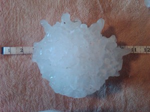
A massive hailstone with a diameter of 8 inches will likely set the record as the largest hailstone in terms of diameter and weight. (NWS)
A massive hailstone that fell in South Dakota on July 23rd set world records for diameter and weight. (NWS)

The massive hailstone that fell over rural South Dakota last week has officially set world records for its weight and diameter. According to the National Oceanic and Atmospheric Administration (NOAA) the chunk of ice easily eclipsed the previous record setter.

On Friday, July 23rd, severe weather rolled through northeastern South Dakota and Stanley, Jones, and Lyman counties. With it was massive hail so big it left holes in the ground the size of coffee cans. Les Scott, a ranch hand, recovered the now record setting stone afterwards.

NOAA’s National Climate Extremes Committee determined that the huge chunk of ice from the sky officially measured 8.0 inches in diameter and weighed 1.9375 pounds (1 pound, 15 ounces) setting records for both. It also measured 18.62 inches in circumference falling just short of breaking the record for that measurement.

The previous record holding hailstone in terms of weight fell on September 3, 1970 in Coffeyville, Kansas and weighed 1.67 pounds.

The stone that previously held the record for diameter measured 7 inches and fell in Aurora, Nebraska on June 22, 2003. That stone still holds the record for circumference having measured 18.75 inches.

While Scott froze it immediately, David Hintz, a meteorologist at NOAA’s Aberdeen weather forecast office, said in a statement some melting had probably occurred resulting in the official measurements being smaller than what the stone was when it first fell.

“Mr. Scott told me the area was littered with large hailstones and the largest had a greater diameter when he first found it. He immediately stored it and several others in his freezer, but a power outage caused some melting,” Hintz said.

South Dakota hail stone measures 8 inches in diameter – likely world record

A massive hailstone with a diameter of 8 inches will likely set the record as the largest hailstone in terms of diameter and weight. (NWS)

Hail is one of the most damaging weather events capable of doing thousands of dollars worth of damage to homes and vehicles and utterly shredding crops. Last week in South Dakota the mother of all hail stones appears to have fallen – a beast weighing nearly two pounds and measuring 8 inches in diameter.

On the evening of July 23rd severe weather rolled through the northeastern corner of South Dakota bringing with it a great deal of hail and some tornadoes. Near Vivian in Faulk County, the hail grew to proportions likely not seen anywhere else.

Ranch hand Les Scott watched the drama unfold as the hail pummeled the surrounding land. The stones were large enough that holes the size of coffee cans were left in the ground.

One particular hailstone caught Scott’s eye due to its sheer size. After retrieving it, he stuck it in his freezer. Word soon traveled about the massive chunk of ice and National Weather Service personnel made preliminary measurements placing the diameter at 8 inches with a circumference over 18 ½ inches.

Yesterday, the service returned to Vivian to transport the stone to the closest certified scale at the local post office to have it weighed. The scale tipped at an amazing 1.9375 pounds. It also had lost a bit in size dropping to 17 inches around.

Scott said the hailstone was quite a bit larger when he first found it, possibly as large as 11 inches in diameter. However, power was out in the area for six hours Friday and after he pulled it out to show various people, it lost some of its mass.

Continue reading South Dakota hail stone measures 8 inches in diameter – likely world record