Tag Archives: tornado

Second day of storms miss Thornton so ThorntonWeather.com goes on the chase

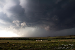
A massive storm churns near Simla, Colorado on Thursday, July 7, 2012. See more photos in the slideshow below.

Mother Nature brought severe weather to northeastern Colorado again yesterday but for the second day in a row Thornton missed out on the action.  Since the storms wouldn’t come to us, ThorntonWeather.com went to the storms.

Thornton seems to be in a bit of a ‘storm drought’ of late with most thunderstorms passing us by and yielding little more than a few rain drops.  Elsewhere along the Colorado Front Range the story has been much different over the last two days.

The setup was near perfect thanks to the formation of a Denver cyclone with moist air pulling in from the south meeting dry air from the north.

ThorntonWeather.com took off in mid-afternoon and headed east to Bennett, then on to Byers and east on Highway 36.  The initial storm cell that was beginning to take shape broke in to three and decisions had to be made on which one to follow.

The southernmost cell seemed to hold the most promise so we headed south, through Limon and tracked the storm near Simla.

The storm would drop tennis ball size hail and push out wind gusts measured at 80mph.  As many as four tornadoes were reported to have been caused by the storm, a number which will be confirmed and finalized later today.

In Elbert County, emergency agencies are conducting damage assessments from at least one of the twisters that tore through the central part of the county.  Extensive damage to as many as seven homes west of Simla was seen.  One person received minor injuries.

Thursday’s storms were the second day in a row for severe weather in the area.  On Wednesday thunderstorms brought massive amounts of hail to the southern Denver metro area and Colorado Springs.  Tornadoes were also spawned although there was no damage from the twisters.

  • Stay up to date with Thornton’s weather: ‘Like’ us on Facebook, follow us on Twitter and add us to your Google+ circles

Stunning satellite imagery shows damage path of deadly EF3 Massachusetts tornado

The Bay State is not one which is normally associated with tornadoes having only seen 152 twisters in the past 60 years – up until last week.  Massachusetts took a big hit last week though as a massive tornado ripped through the Springfield area killing four people.

Satellite imagery released by the USGS and NASA (below) shows the scar the EF3 tornado left on the earth as it ripped a path 39 miles long.  The image taken by Landsat shows the path of the half-mile wide tornado as it cut through Sturbridge and beyond.

The twister first touched down near Westfield and then moved into Springfield after crossing the Connecticut River.  Both areas saw extensive damage to buildings and homes as the twister moved through.

As it moved east the tornado debarked trees and struck the town of Monson where extensive damage was seen.  It eventually hit Brimfield Sate Forest and then the Southbridge Airport.

When it was done, four people were killed  and 200 injured.  Latest estimates put the damage cost at $90 million making it the most costly natural disaster in the state’s history.

Two smaller, EF1 rated tornadoes also struck nearby on the same day.  One caused a damage path 3.6 miles long and the other 1.3 miles long.

Related:

Image taken by the Landsat satellite on June 5, 2011 showing the damage path from an EF3 tornado that struck Massachusetts on June 1, 2011. (USGS / NASA)
Image taken by the Landsat satellite on June 5, 2011 showing the damage path from an EF3 tornado that struck Massachusetts on June 1, 2011. Click the image for a larger version. (USGS / NASA)

Severe weather continues to cause destruction, claim lives

Tornadoes and other forms of severe weather have caused extraordinary damage and loss of life this spring across the nation.

Tornadoes, damaging wind, hail and flooding rains are a fact of life in the United States in the springtime.  This season however has seen an absolutely devastating series of storms systems that have brought extraordinary levels of destruction and loss of life.

Among our writing assignments for Examiner.com we are the Natural Disasters Examiner.  Of late the vast majority of our coverage has centered on the severe weather.  Below are some of the stories we have written in recent days about the outbreaks.  Follow the links for greater detail including photos and videos.

Deadly severe weather season continues as 13 killed across three states
Mother Nature continues to pile on more severe weather in what has been a particularly devastating and deadly spring in the United States.  Tornadoes, hail, and damaging wind struck the central and southern U.S. yesterday killing at least 13 people.

Deadly Joplin, Missouri tornado rated EF5; Death toll climbs to 125
The tornado that ripped through the southwestern Missouri town of Joplin on Sunday has quickly achieved its place in the annals of weather history.  The National Weather Service has completed its evaluation of the deadly twister and given it the highest possible rating even as the death toll continues to climb.

2011 tornado statistics provide chilling empirical evidence of a deadly season
The scenes of utter devastation have been played out across the nation this spring as tornadoes rip across the landscape.  The latest statistics for the tornado season show clearly that the death toll has been staggering and the number of twisters record-setting.

Tornado statistics: Top 25 deadliest tornado seasons in U.S. history
On average the United States suffers 80 deaths per year because of tornadoes, more than any other nation on the globe.  As warning systems and forecasts have improved the number of tornado-related fatalities has been decreasing but history shows that the loss of life can still be substantial.

Tornado statistics: Top 25 deadliest tornadoes in U.S. history
With an average of 1,200 tornadoes per year, more twisters strike the United States than any other nation in the world.  These storms can strike with deadly effects with a single twister covering more than a hundred miles, wiping out entire towns and claiming dozens of lives.

Video captures sheer terror of residents as tornado rips apart Joplin, Missouri
The deadliest tornado since 1953 ripped through the southwestern town of Joplin, Missouri yesterday reducing parts of the town to rubble.  A new YouTube video captures the terror felt by residents as they hudled in the back of a convenience store as the twister made a direct hit.

Deadliest tornado since 1953 strikes Joplin, Missouri

Cars and debris are strewn about in front of the devastated St. John's Regional Medical Center in Joplin, Missouri. (Twitpic / borntorunnergrl)
Cars and debris are strewn about in front of the devastated St. John's Regional Medical Center in Joplin, Missouri. Click the image to view a slideshow of the devastation. (Twitpic / borntorunnergrl)

Following on last month’s devastating bout of severe weather the month of May had started out much quieter.  That silence from Mother Nature however was shattered yesterday as a massive tornado ripped through Joplin, Missouri killing at least 89 people.

Late afternoon brought storm clouds to southwestern Missouri and a tornado warning soon sounded.  Residents of Joplin had 20 minutes to find cover before the massive tornado struck the heart of town.

  • Scroll down for amazing video of the Joplin tornado as it grows with amazing speed.  Also be sure to check out the slideshow of images of the devastation.

As frightened residents huddled in basements and bathrooms, the twister destroyed as much as 75% of the town.  The high school, regional medical center, an elementary school as well as thousands of other homes and businesses were destroyed.

The human toll from the tornado was devastating.  At latest report 89 people were killed and emergency crews continue to search for survivors as the death toll is expected to climb.

Not since June 9, 1953 has a deadlier single tornado been responsible for so much death.  As is, the Joplin tornado would rank as the 21st deadliest tornado in the history of the United States.  In all likelihood it will climb further up the rankings.

Slideshow: Scenes of destruction played out in Joplin, MO after tornado strikes. (Examiner.com)

The National Guard has been activated by Missouri Gov. Jay Nixon to help with recovery efforts.  Relief agencies across the nation were deploying personnel and supplies to assist as well.

The tornado that struck Joplin was part of a larger set of storms that struck multiple states on Sunday.  In all, 48 tornadoes were reported including one near Minneapolis that claimed the life of one person.

More from the Natural Disasters Examiner:

Good Friday tornado strikes St. Louis airport; Twister rated EF4

Extensive damage seen at St. Louis airport after tornado strikes. (Twitpic / LakishaJackson)
Extensive damage seen at St. Louis airport after tornado strikes. View more images in the slideshow below. (Twitpic / LakishaJackson)

Severe weather struck the St. Louis area Friday evening bringing large hail, damaging winds and powerful tornadoes.  One twister tore a lengthy pass through the city hitting the airport and causing extensive damage to the facility and nearby homes.

The most significant component of the storm system was a powerful EF4 tornado packing winds of more than 166mph at its peak and causing damage nearly one-half mile wide at the widest point.  Initially touching down west of Lambert-St. Louis International Airport, the tornado followed a 22 mile long path destroying homes and causing extensive damage at the airport.

At the airport tornado sirens were sounded as the storm approached and many of the estimated 500 travelers at the airport sought shelter.  The powerful tornado struck and blew out 60 percent of the windows in the main terminal building and partially lifted the roof on Concourse C.

On the grounds of the airport baggage carts were tossed about and the tarmacs were littered with debris.  Parking areas saw cars smashed and thrown into each other like toys.

Residential areas to the west of the airport where the tornado first touched down bore the brunt of the damage, particularly in the community of Bridgton.  Many homes were reduced to piles of wood and cinder while trees and power lines were downed.

After crossing the airport the tornado continued on its path damaging other buildings and homes.  Extensive roof damage was caused to the First Baptist Church of Ferguson and a Little Caesars Restaurant saw its roof torn completely off.

Slideshow: Lambert-St. Louis International Airport struck by tornadoThe tornado then crossed the Mississippi River into Illinois.  Three homes saw their roofs torn off while others sustained significant damage.

Despite the twister’s lengthy path of destruction and powerful nature, no fatalities were reported.  At the airport five people were treated for relatively minor injuries.

Do you know what to do to protect yourself and your family when severe weather strikes? The same type of events that struck in recent days can and do occur in Colorado.  Check out our Severe Weather Awareness series for more:

What not to do when faced with a tornado

When faced with a tornado what would you do?  Do the smart thing and drop the camera and seek shelter.
When faced with a tornado what would you do? Do the smart thing and drop the camera and seek shelter.

Just as we were wrapping up Severe Weather Awareness Week on ThorntonWeather.com, disaster struck the nation’s south.  Dozens of tornadoes brought death and destruction and at the same time Mother Nature allowed us to learn valuable lessons.

Extreme weather events have gotten more and more attention thanks to Twitter, YouTube, Facebook and other forms of social media.  Television shows like Discovery’s Storm Chasers and shows on the Weather Channel feed a seemingly insatiable desire to see these events.  They give the impression that anyone can stare down major storms with few repercussions but that is far from the truth.

Professional weather watchers, meteorologists and storm chasers cringe at some of what we see when these events happen.  People with seemingly no clue of the destructive and unpredictable nature of what they are looking at put themselves in harm’s way for 60 seconds of fame.

The severe weather outbreak of recent days highlights the folly of those uninitiated and untrained in these phenomena.  One particularly striking video has emerged of a man in Wilson, North Carolina watching as a tornado approaches, talking on the phone and shooting video.

The video (below) is scary to watch as the man is oblivious to what is coming toward him at 50mph.  We implore all ThorntonWeather.com readers to do the smart thing – seek shelter when severe weather.  Don’t become a statistic for a photo or a video.

For more on social media and the lessons that can be learned, check out this story from the Natural Disasters Examiner.

Video captures tornado ripping through northwestern Iowa

Saturday evening the stage was set for severe weather across the nation’s heartland and Mother Nature came through in spades.  More than a dozen tornadoes were reported as were scores of significant hail events.

Despite the number of events most resulted in little damage.  However one tornado, by some accounts as big as three quarters of a mile wide, struck the town of Mapleton, Iowa.  This massive wedge tornado struck at 7:21 CDT and caused significant damage in the town.

The video below was captured by storm chasers as they tracked the dangerous tornado.

Alabama tornadoes captured on video ripping apart store

March 9, 2011 - This truck was flipped on its side by the tornado that struck Theodore, AL.  (Twitpic/WKRG_Jessica http://twitpic.com/47u3yv)
March 9, 2011 - This truck was flipped on its side by the tornado that struck Theodore, AL. (Twitpic/WKRG_Jessica http://twitpic.com/47u3yv)

The Deep South was the scene of some nasty weather yesterday as severe storms brought damaging winds, flash floods and tornadoes to four states in the region.  One particularly damaging tornado struck Theodore, Alabama and surveillance video captured the effects of the storm as it tore apart a hardware store.

According to the National Weather Service the tornado initially touched down at about 9:00am local time yesterday as an EF1.  As it tracked to the northeast the tornado increased to EF2 strength packing winds up to 120mph.  At its maximum size it was 150 yards across.

Four people suffered injuries from the tornado and 25 residential and commercial structures were damages.  Cars in a strip mall were tossed about like toys and a gas station awning collapsed.

Alexander Hardware and Small Engine was in the path of the tornado when it was at its strongest after it passed over Theodore Dawes Road.  The store sustained a near direct strike from the twister.

Video captured by Alexander’s surveillance cameras provide video proof of the power and fury of the twister.  In one video, employees are seen tentatively looking out the front door before running for cover as the tornado struck.  The second video provides an overall view of the store interior as the tornado hits sending shelves and merchandise flying.

U.S. Army digs out from New Year’s Eve tornado

The housing areas of Fort Leonard Wood were devastated by a New Year's Eve tornado. View more images in the slideshow below.  (4th Maneuver Enhancement Brigade)
The housing areas of Fort Leonard Wood were devastated by a New Year's Eve tornado. View more images in the slideshow below. (4th Maneuver Enhancement Brigade)

An unusual New Year’s Eve tornado outbreak brought on twisters across Arkansas and Missouri causing widespread destruction.  Seven lives have been reported lost and one tornado struck Fort Leonard Wood, a U.S. Army base in northwestern Missouri.

Strong thunderstorms spawned the tornado outbreak that included 44 tornado reports although the actual number of twisters is likely much lower once duplicates are removed.  Three fatalities were recorded in Arkansas, four in Missouri.

Preliminary damage assessments from the National Weather Service indicate the two most significant tornadoes were EF-3 twisters packing winds as high as 150 mph. 

The Cincinnati, Arkansas twister started near the in Oklahoma near the town of Westville.  The tornado continued into Arkansas tearing a path 21 miles long and 500 yards at its widest. Click here for the damage assessment from the Tulsa, Oklahoma National Weather Service office.

In Missouri the weather service has begun analysis of four confirmed twisters rated EF0, EF1, EF2 and EF3.  The most powerful storm struck the Sunset Hills area southwest of St. Louis and at one point created a damage field 1/4 of a mile wide. Click here for the damage assessment from the St. Louis, Missouri National Weather Service office.

Slideshow: Fort Leonard Wood Army base devastated by New Year's Eve tornado

At the Army post in Pulaski County, images show extensive damage to structures at the base, many of which were part of the base housing and training areas.  Officials said that only four minor injuries were sustained at the base. 

View images of the destruction at Fort Leonard Wood in the slideshow to the right.  For more on this story, visit the Natural Disasters Examiner and these stories:

Oregon town struck by rare EF-2 tornado

An EF-2 tornado struck the town of Aumsville, Oregon on Tuesday damaging 50 structures. Click the image for a slideshow of the damage from Examiner.com.

Tornadoes are not usually asssociated with Oregon or December and certainly not the two of them together.  Tuesday however that rarest of event did occur when an EF-2 tornado packing 110+ mph winds struck the town of Aumsville.

The first report of the tornado was at 11:59am PST when emergency personnel reported spotting the twister.  Power was knocked out to thousands and several homes and businesses were damaged or destroyed.  Two minor injuries were reported. 

The National Weather Service completed their preliminary investigation of the twister and rated the tornado as an EF-2 with winds between 110 and 120 mph.  At its maximum the twister was 150 yards wide and carved an intermittent path 5 miles long. 

For more details on the tornado including video and a photo slideshow of the damage, please visit the Natural Disasters Examiner.