Tag Archives: tornado

2009 tornado season deadly but below average thus far

Thus far the 2009 tornado season has been quiet compared to years past.  (AP Photo)
Thus far the 2009 tornado season has been quiet compared to years past.

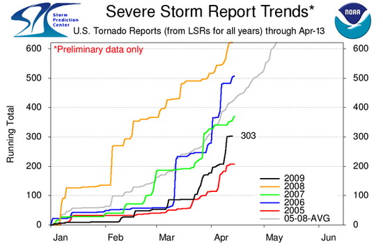
The severe weather season has started in earnest now and last week’s deaths of five people from tornadoes highlight the danger this time of year brings.  Thus far however, 2009 is below the three year average not only in the total number of tornadoes reported but also in the number of tornado related deaths.

In terms of the number of tornado reports, through yesterday there have been 303 preliminary reports in 2009.  Over the last three years the United States has averaged 391 per year through April 13th.  That means that 2009 is thus far 23% below average.

Tornado Reports by Year
Through April 13th
2009
2008
2007
2006
3yr Avg
303
494
286
392
391

 It is important to note that all of those counts are based on preliminary tornado reports.  The actual number of tornadoes that occurred typically is reduced by about 15 percent as duplicate reports are eliminated.  Nevertheless, this does show 2009 is running well below average. 

In terms of fatalities caused by twisters, there have been 14 thus far this year.  This too is below the three year average of 54 per year through April 13th.  That is a large 75% reduction which is notable and something certainly to be thankful for.

Tornado Fatalities by Year
Through April 13th
2009
2008
2007
2006
3yr Avg
14
70
52
50
57

 It is important to note that while this year shows promise for being a less deadly and less destructive tornado season, the season is far from over.  May and June are typically the most active months of the season and one large outbreak could radically change these numbers.
[nggallery id=3]


Tornado Reports for 2009

Wildfires and tornadoes claim lives across the nation

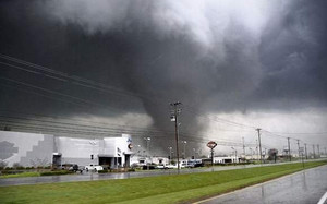
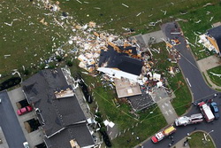
A tornado rips through Murfreesboro, TN where a mother and child lost their lives in the twister.

The end of the week saw severe weather claim the lives of seven people across the nation on Thursday and Friday.

Mena, Arkansas Tornado Claims Three Lives

Daylight Friday in the western Arkansas town of Mena brought a devastating sight after a tornado tore through the town killing three people and injuring at least 24.  Reports are that hundreds of homes and businesses have been destroyed in the town of 5,000.

Tornado sirens blared yesterday evening in the town warning of the coming danger.  At about 8:30pm local time the twister struck.  Two women and one man lost their lives in the storm.  One victim died in a collapsed house, another in a front yard and the third in a Masonic Lodge. 

Click here for more details in our story on Examiner.com.

Wildfires in Texas and Oklahoma Wildfires Claim Two Lives, Injure Dozens

Wind-driven wildfires in Texas And Oklahoma proved deadly Thursday afternoon as a Texas couple was killed in the blazes and dozens more injured.  The fires in western and central Oklahoma injured at least 34 people and burned over 100 homes.  In Texas, a former television reporter and his wife were killed.

High winds, low humidity and an abundance of dry fuels sparked the wildfires and made for prime conditions for them to quickly burn out of control.  In Oklahoma the fires started along I-35 and forced its closure for a time although it is now open.  Entire towns were evacuated including Healdton, Sparks, Velma, Wellston and Midwest City.  

Click here for more details in our story on Examiner.com.

Mother and child killed by tornado in Murfreesboro, Tennessee

A mother and her three month old baby were killed in Murfreesboro, Tennessee today when a tornado went through the central part of the state Friday.  The Tennessee Emergency Management Agency reports that 30 were also injured by the twister as a line of storms stretching from Alabama, across Tennessee and into Kentucky wreaked havoc.  The deadly twister comes on the heels of one that killed three people in Arkansas Thursday.

The mother and child whose lives were lost were taken to Middle Tennessee Medical center but were dead when they arrived.  The city of 105,000 saw roofs ripped from homes and trees downed as the twister struck the northern and western parts of the city. 

Click here for more details in our story on Examiner.com.

Storm spotter training gets started this coming week

Want to be an official storm spotter or maybe just want to learn more about severe weather?  Here’s your chance!
Want to be an official storm spotter or maybe just want to learn more about severe weather? Here’s your chance!

We have written before about the great opportunity the National Weather Service provides by giving storm spotter training during the start of the severe weather season.  That time is now here and training sessions start in the coming week and new sessions have been added since we last reported on the topic.

The storm spotter program is a nationwide program with more than 280,000 trained spotters.  These volunteers report weather hazards to their local National Weather Service office providing vital information when severe strikes.  Data from spotters include severe wind, rain, snow measurements, thunderstorms and hail and of course tornadoes. 

Don’t think tornadoes can hit Thornton?  Click here for a look back at the June 3, 1981 twister that hit the city!

Storm spotters are part of the ranks of citizens who form the Nation’s first line of defense against severe weather. There can be no finer reward than to know that their efforts have given communities the precious gift of time–seconds and minutes that can help save lives.

By completing one of these training classes you can become an official storm spotter.  When severe weather strikes, you can report it by calling a special toll free number or submit your report via the National Weather Service’s website.

These are great sessions for anyone wanting to learn more about the severe weather we experience in Colorado, whether you want to be an official spotter or not.  All training is free.  Topics include:

  • Basics of thunderstorm development
  • Fundamentals of storm structure
  • Identifying potential severe weather features
  • Information to report
  • How to report information
  • Basic severe weather safety

To learn more about the program, see here:  http://www.crh.noaa.gov/bou/awebphp/spotter.php

Here are the dates, times and locations announced thus far (click here to go to the NWS site for the latest). 

 
March, 2009 – Upcoming
Day City, State Time Location
05 Greeley, CO
(Weld County)
6:30pm MST Weld County Training Facility 1104 H Street Greeley, CO
  Contact Information: rrudisill@co.weld.co.us
19 Westminster, CO
(Adams County)
6:30pm MDT Front Range Community College 3645 West 112th Ave. room C0804 Westminster, CO 80031
  Contact Information: Ryan.Girard@frontrange.edu
23 Julesburg, CO
(Sedgwick County)
6:30pm MDT Julesburg Fire Hall
  Contact Information: ptsports57@yahoo.com
24 Holyoke, CO
(Phillips County)
9:00am MDT location to be determined.
  Contact Information: Philcoadmin@pctelcom.coop
24 Haxtun, CO
(Phillips County)
6:30pm MDT location to be determined
  Contact Information: fix5@haxtuntel.net
30 Westminster, CO
(Adams County)
2:30pm MDT Front Range Community College 3645 West 112th Ave. room C0804 Westminster, CO 80031
  Contact Information: Ryan.Girard@frontrange.edu
31 Sterling, CO
(Logan County)
6:30pm MDT Sterling Fire Hall Community room, 420 S. Oak Street
  Contact Information: OWENS@sterlingcolo.com
 
April, 2009 – Upcoming
Day City, State Time Location
02 Loveland, CO
(Larimer County)
9:00am MDT Rialto Theater 228 East 4th Street Loveland, CO 80537
  Contact Information: mialyp@ci.loveland.co.us
02 Fort Collins, CO
(Larimer County)
7:00pm MDT City Council Chambers 300 Laporte Avenue Fort Collins, CO
  Contact Information: nilssoed@co.larimer.co.us
06 Brush, CO
(Morgan County)
7:00pm MDT Morgan County Fairgrounds Ellsworth Street, Brush
  Contact Information: senfante@co.morgan.co.us
14 Commerce City, CO
(Adams County)
1:00pm MDT Adams County Sheriff’s Dept. 4201 East 72nd Avenue Commerce City, CO 80022
  Contact Information: JSchwarz@co.adams.co.us
22 Akron, CO
(Washington County)
6:30pm MDT Washington County Fairgrounds Event Center, Akron
  Contact Information: mmcaleb@co.washington.co.us
23 Parker, CO
(Douglas County)
7:00pm MDT Parker Fire District HQ 10235 Parkglenn Way Parker, CO
  Contact Information: kc0mht@msn.com
 
May, 2009 – Upcoming
Day City, State Time Location
02 Denver, CO
(Denver County)
9:00am MDT Denver Police Station 3 1625 South University, Denver
  Contact Information: Mike.Rappe@denvergov.org

Windsor Tornado to be featured on the Weather Channel

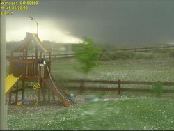
The Weather Channel's new season of Storm Stories will feature the Windsor Tornado from May 2008.  This scary image was taken by the webcam of MyWindsorWeather.com as the twister tore through the town on May 22, 2008.
The Weather Channel's new season of Storm Stories will feature the Windsor Tornado from May 2008. This scary image was taken by the webcam of MyWindsorWeather.com as the twister tore through the town on May 22, 2008.

This Sunday, February 22nd at 6:00pm MST, the Weather Channel will premiere the new season of its series Storm Stories.  Most notably, the first episode will highlight a weather event from last year that struck very close to home – the May 22nd Windsor Tornado

For those that haven’t seen Storm Stories, it is an exciting, sometimes scary and sad series discussing significant weather events as seen through the eyes of those that experienced it firsthand.  For the Sunday episode, renowned storm tracker Jim Cantore from the Weather Channel will tell the story of the twister using footage from a variety of sources, including the video most have seen from KUSA (see below).  

Area residents were interviewed for what is sure to be an extraordinary episode and will serve as a poignant reminder that we in the Denver area live at the edge of tornado alley. Click here to view a story about the filming of the episode on the Windsor Beacon’s website.

The kickoff of the new season of Storm Stories is actually the beginning as well of the Weather Channel’s ‘Tornado Week’ in which twisters are front and center.  Other episodes of note during the week:

  • Monday – the “Parkersburg, IA, Tornado” on May 25, 2008, killed seven people and demolished the southern half of the town; first-hand accounts are given by residents.
  • Tuesday – the “Greensburg, KS, Tornado” on May 5, 2008, wiped out the entire town.  The story is told through the experiences of next-door neighbors who saved a mother and her baby from the rubble.
  • Wednesday – “Super Tuesday” tornadoes cut a swath over a wide area Feb. 5, 2008; touching stories come from people that were affected in Arkansas, Kentucky and Tennessee.
  • Thursday – the “Boy Scouts Tornado” hit the Little Sioux Scout Ranch in western Iowa last June, catching everyone off guard.  The surviving scouts are forced to put their training to use in the midst of a terrifying situation to help keep injured scouts alive in the aftermath.

Be sure to check the Weather Channel’s website as there are a lot of other interesting shows related to tornadoes throughout the week.  Click here to view a press release with the full announcement

Thank you to Ryan of MyWindsorWeather.com for bringing this story to our attention.

National Storm Chaser Convention hits town – Severe weather season is almost here

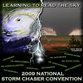
Denver will host the 11th annual National Storm Chaser Convention from February 13th to February 15th.

The 11th annual National Storm Chaser Convention hits town this weekend as some of the nation’s premier storm chasers converge on Denver.  Whether you are a seasoned chaser or just someone with an interest in the weather, this is an extraordinary opportunity to mingle with and hear from some of the biggest names in severe weather.  The event is organized every year by two of the biggest names in storm chasing – Roger Hill and Tim Samaras.

Held at the Red Lion Inn in Parker, the event kicks off Friday night with an ice-breaker and a chance to mingle with other weather enthusiasts.  Saturday morning the event starts in earnest with an extraordinary slate of speakers covering an array of topics.  Saturday night is the infamous video night where videos and photos from last year’s record setting year of tornadoes are sure to play a big part and Sunday the convention continues with additional speakers. 

Some of the speakers this year include:

Also notable, the National Weather Service will be holding a free storm spotter training session Sunday afternoon.  These are a great way to learn much more about severe weather.  Click here to learn more about storm spotter training and what it involves.

You can learn more about this great event and see the complete agenda on the convention website at www.chaserconvention.com.  

Here’s a little storm chasing video to get you pumped up for the event:

2008 had second highest number of tornadoes on record

2008 will go down as the second most active year for tornadoes on record.

According to the latest data from the Storm Prediction Center, the number of confirmed tornadoes in 2008 will finish well above average.  Final numbers through the end of October count 1,621 twisters, exceeding the average over the last ten years of 1,270 per year. 

Once the data is finalized, the year will most likely go down as the second most active tornado year on record since record keeping began in 1950.  2004 was the most active year with 1,871 and the number three year was 1998 with 1,424. 

While some alarmists may look to climate change as a reason for what seems to be an increase in the number of twisters, the explanation is actually much simpler than that.  Technology like radar now allows us to ‘see’ tornadoes in rural areas that normally would have gone unreported.  Further, as population grows, there are simply more people living in areas that were unpopulated before and thus twisters are spotted more often. 

Get more local news and weather information on Examiner.com.
This article and many more are posted to the Denver Weather Examiner site.
Visit Examiner.com for more local Denver news and weather.

What about Colorado?  Certainly we all remember the Windsor tornado in May.  Beyond that, there were a total of 61 tornado reports in 2008.  The actual number of twisters will certainly be lower than that once duplicate reports are removed and the tally is official.

TORNADO TOTALS AND RELATED DEATHS...THROUGH 12/31/2008
NWS STORM PREDICTION CENTER NORMAN OK
0726 AM CST THU JAN 01 2009

    ...NUMBER OF TORNADOES...            NUMBER OF        KILLER
                                       TORNADO DEATHS    TORNADOES
     ..2008..  ..2007.. 2006 2005  3YR            3YR            3YR
    PREL  ACT PREL  ACT  FIN  FIN   AV 08 07 06 05 AV 08 07 06 05 AV
JAN  136   84   29   21   47   33   34  7  2  1  4  2  4  1  1  2  1
FEB  230  148   87   52   12   10   25 59 22  0  0  7 12  3  0  0  1
MAR  150  126  214  171  150   62  128  4 27 11  1 13  3 10  7  1  6
APR  189  189  187  165  245  132  181  0  9 38  0 16  0  3  9  0  4
MAY  597  460  282  250  139  123  171 43 14  3  0  6 10  4  1  0  2
JUN  394  289  152  128  120  316  188  7  0  0  0  0  4  0  0  0  0
JUL  120   94   55   69   71  138   93  1  0  0  0  0  1  0  0  0  0
AUG  145   99   87   73   80  123   92  0  1  1  4  2  0  1  1  3  2
SEP  133  111   63   51   84  133   89  2  0  1  1  1  1  0  1  1  1
OCT   28   21  115   87   76   18   60  0  5  0  0  2  0  3  0  1  1
NOV   20    -    7    7   42  150   66  2  0 10 28 13  2  0  3  5  3
DEC   50    -   22   19   40   26   33  0  1  2  0  1  0  1  2  0  1
    ----  --- ---- ---- ---- ---- ---- --- -- -- -- -- -- -- -- -- --
SUM 2192 1621 1300 1093 1106 1264 1159 125 81 67 38 62 37 26 25 13 21

PREL = 2009 PRELIMINARY COUNT FROM NWS LOCAL STORM REPORTS.
ACT = ACTUAL COUNT BASED ON NWS STORM DATA SUBMISSIONS.

TORNADO-RELATED FATALITY NUMBERS ARE ENTERED WHEN CONFIRMED BY NWS
FORECAST OFFICES.

Top weather story of 2008 – The Windsor tornado

This amazing image of the Windsor tornado was taken from a backyard webcam. Image courtesy MyWindsorWeather.com.

May 22, 2008 started like most other spring days in Colorado.  That Thursday morning had dawned with relatively mild temperatures and a touch of humidity in the air.  That moisture in the air was a warning sign as moist air from the Gulf of Mexico was entering the state and a signal of the potential for severe storms.  No one knew though just what was in store for a small town in northeastern Colorado.

As temperatures rose in the morning, the moist air near the ground mixed with fast moving dry air aloft and created conditions ideal for supercell thunderstorms and tornadoes.  Hail began to fall around 11:20am near Platteville, a harbinger of things to come.  As the weather situation became much more excited and confused, reports of a twister on the ground near Gilcrest at 11:29 rolled in.

A classic wedge tornado had formed and was moving to the north-northwest at a leisurely 30 mph wreaking havoc and destruction all along its path.  Examiner.com soon posted a special report at 11:30 warning of the twister and showing its expected path.  It narrowly missed the town of Milliken, dumping baseball sized hail on it instead.  The twister was now a full mile wide with winds in excess of 136 mph and at 11:57am, the storm struck Windsor, home to 16,000 Coloradoans.  By the time it was done with the town, it had claimed one life, destroyed 80 homes and damaged nearly 770 others.

For a total of nearly 45 minutes the storm carved a 35 mile long path of devastation and all along its path it left the evidence – houses with nothing but a foundation left, power poles snapped like matchsticks, semi-trailers overturned like toy cars, mangled pieces of metal and shards of wood.

Tornadoes in Colorado are not uncommon with an average of 60 per year, although most do occur on the eastern plains in more rural areas.  The storm was only the second deadly tornado in Colorado in the last 10 years (the Holly tornado in 2007 being the other) but it served to highlight that the Front Range is on the western edge of Tornado Alley.  Weld County is in fact Colorado’s own tornado capital having had more twisters than any other county since 1950.

When it was over, Coloradoans showed their sense of community in helping the affected areas.  The Red Cross immediately went into action as did the state government in calling out the National Guard to help.  Donations poured in and other relief agencies provided food and shelter to those left homeless.  While the Windsor Tornado was an example of the worst of Mother Nature, the storm also showed us the best of mankind.  No other weather event comes close to being Colorado’s biggest weather story of 2008.

Below is some amazing raw video from 9News of the tornado as it moved north.

Green skies – Storm Chasers episode 7 sneak peek

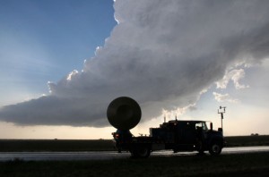
The Doppler On Wheels (DOW) surveys storm clouds looking for tornadoes.

Our friendly little bird from the Discovery Channel continues to offer us – and you – sneak peeks of coming episodes of Storm Chasers.  The episode guide for this coming Sunday’s episode says:

HAIL TO THE BEAST – Nov. 30 at 9 p.m. ET/PT
Reed and Josh’s teams struggle to find the perfect storm in Nebraska. Reed’s girlfriend Jene gets lost in a deadly hailstorm while the DOW fleet mistakenly drives into an oncoming tornado.

The sneak peek the Discovery Channel has offered us this week is aptly titled, “Green Skies.”  As anyone who has been around severe weather knows, green skies mean hail – and tornadoes.  We see this is Denver occasionally but in this clip, the TornadoVideos.net team finds themselves separated from each other while under a sky completely filled with green clouds.  It is a rather eerie – and scary – effect.

For more information:  The Discovery Channel – Storm Chasers

ThorntonWeather.com sneak peek – Storm Chasers episode 4 preview

Now that is heavy metal!  The TIV 2 is a machine designed specifically for driving into a tornado.  Image courtesy Discovery Channel.
Now that is heavy metal! The TIV 2 is a machine designed specifically for driving into a tornado. Image courtesy Discovery Channel.

The 2008 tornado season was historical for its ferocity.  Record breaking numbers of twisters struck Tornado Alley with a frequency not seen in years.  In June, north central and western Kansas were ground zero for tornado outbreaks that went on for days. 

ThorntonWeather.com continues to be granted special access to the Discovery Channel’s Storm Chasers (Sunday’s @ 8:00pm MST) footage.  In this coming Sunday’s episode, the crew finds itself right in the thick of things.  The episode guide says:

No Place Like Kansas – Nov. 23 at 10 p.m. ET/PT
With the DOW and all the chase vehicles up and running again, the team finds themselves hunting in the same territory as the rival TVN crew. Tornadoes are forming all over western Kansas on what looks like the biggest day of the season.

This week’s sneak peak – A funnel cloud begins to form in the skies over Quinter, Kansas as the the Storm Chasers scramble to approach it.

ThorntonWeather.com sneak peek – Storm Chasers episode 4 preview

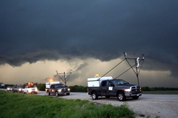
The probe trucks await an opportunity to deploy their instruments on Discovery Channel's Storm Chasers.

We continue to be granted sneak peeks of new episodes of the Discovery Channel’s Storm Chaser’s (Sunday’s @ 8:00pm MST).  Last week corn husks fell from the sky on the scout crew after a tornado had passed and Reed and the TornadoVideos.net team chased a twister in the dark. 

As the show chronicles the 2008 storm season, it is now getting into what was the most intense period of the summer.  This coming Sunday’s episode guide says:

NIGHTMARE ON DOW STREET – Nov. 9 at 10 p.m. ET/PT
Halfway into the season, TIV1 returns to action, and the whole team heads first toward Oklahoma and then into Arkansas. Monster hail storms batter the fleet, but the vehicles forge ahead as tornadoes start touching down all across this part of the Great Plains. Everyone gets to feast on the tornado bounty, but after dark, a twister chases the chasers in the streets of Stuttgart, Arkansas.

This week’s episode sneak peek –  The storm chasers race to outrun a devastating twister as it quickly catches up to the team’s TIV-1 vehicle in this clip from Storm Chasers.