Tag Archives: tornadoes

New Red Cross tornado safety guidelines spark controversy

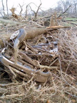
Should you ride out a tornado in your vehicle?  The  Red Cross has issued new guidelines that conflict with those from the National Weather Service.  This photo is of a Ford Ranger pickup truck that was blown one-quarter mile and found underneath tree debris after the March 28, 2009 tornado near Corydon, KY.  (NWS)
Should you ride out a tornado in your vehicle? The Red Cross has issued new guidelines that conflict with those from the National Weather Service. This photo is of a Ford Ranger pickup truck that was blown one-quarter mile and found underneath tree debris after the March 28, 2009 tornado near Corydon, KY. (NWS)

The American Red Cross has updated its tornado safety guidelines, modifying longstanding recommendations putting them in conflict with those provided by NOAA and the National Weather Service. The new guidelines no longer recommend evacuating a car if a tornado is about to strike and finding a low-lying ditch to hide in. Instead, the Red Cross is now recommending remaining in the vehicle.

Until now, all tornado safety guidelines were consistent in saying that remaining in a car during a tornado, just like a mobile home, is one of the worst possible places to be. The vehicle stands a great chance of being picked up and thrown and destroyed with its occupants trapped inside.

The National Weather Service, and the Red Cross until now, believes that lying flat in a ditch provides a greater chance of survival. Your body provides a smaller target for winds and by being in a ditch, debris and winds have a better chance of passing over you.

The new guidelines from the Red Cross say:

  • If you are caught outdoors, seek shelter in a basement, shelter, or sturdy building. If you cannot get to shelter, a recent study* suggests doing the following:
    • Get into a vehicle, buckle your seat belt, and try to drive at right angles to the storm movement and out of the path.
    • If strong winds and flying debris occur while you are driving, pull over and park, keeping seat belts on and the engine running. Put your head down below the windows, covering with your hands and a blanket if possible.

Compare this to the guidelines from the National Weather Service’s Storm Prediction Center:

Vehicles are extremely dangerous in a tornado. If the tornado is visible, far away, and the traffic is light, you may be able to drive out of its path by moving at right angles to the tornado. Otherwise, park the car as quickly and safely as possible — out of the traffic lanes. [It is safer to get the car out of mud later if necessary than to cause a crash.] Get out and seek shelter in a sturdy building. If in the open country, run to low ground away from any cars (which may roll over on you). Lie flat and face-down, protecting the back of your head with your arms.

Researchers for the Red Cross cited studies from historical tornado damage, injuries and deaths. Rick Bissell of the University of Maryland-Baltimore County was head of the committee that wrote the new recommendations and had posted to his blog, “We found no evidence to support the NWS suggestion that people should lie in a ditch during a tornado if they cannot find solid shelter.”

It should be noted that the “recent study” the commendations cite is actually an older one from 2002. Further, Mr. Bissell’s blog comments have since been removed from the website.

Now Americans are faced with two competing recommendations which could make the difference between life or death. Many believe the Red Cross’ issuing of these new recommendations without collaboration with the weather experts at the National Weather Service is irresponsible. However, there are no hard rules when dealing with Mother Nature and what works in one situation, may not work in a comparable one at a different time.

This vehicle was destroyed by a tornado - if you were in it, would you have survived?

It is my opinion that the traditional recommendations of the National Weather Service are the best choice. As we wrote in our Severe Weather 101 – Tornadoes and tornado safety article:

When driving in open country and you see a tornado, simply drive away from the path of the tornado – usually at a 90 degree angle to the path is best. While we all have seen video of people doing it, do not seek shelter beneath a highway underpass as these act like wind tunnels and actually serve to increase the wind speed and collect flying debris. In the extreme situation that you simply cannot get away from a tornado, abandon your vehicle immediately. Lie down in a ditch or culvert and cover your head. This isn’t a particularly good option, but it is safer than remaining in a vehicle.

If you are caught outside with no place to seek shelter, crawl into a ditch or culvert and cover your head. Getting as low as possible will decrease the odds of you being struck by flying debris. This is not ideal, but it is your best course of action.

Ideally you would of course escape the tornado by outrunning it as outlined above or seek shelter in a sturdy building – knock on doors if you have to.

Justin Berk, Baltimore Weather Examiner and professional meteorologist had this to say:

If you are that close to a tornado, pray! If the option to drive the other way is not available… it is luck of the draw. I used to tell my students to get out and curl down in a low ditch by the road with their heads covered – to protect from flying debris. Honestly, who is going to think of getting outside when it gets worse? The car may provide some protection from flying debris. Which in a tornado, could be another car. I can see the fault in getting out of your car, only to get hit by another. The myth of hiding under a highway overpass has been proven wrong. So, drive away or pray!

2009 tornado season deadly but below average thus far

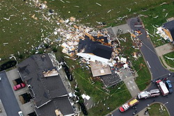
Thus far the 2009 tornado season has been quiet compared to years past.  (AP Photo)
Thus far the 2009 tornado season has been quiet compared to years past.

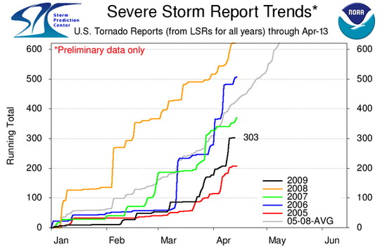
The severe weather season has started in earnest now and last week’s deaths of five people from tornadoes highlight the danger this time of year brings.  Thus far however, 2009 is below the three year average not only in the total number of tornadoes reported but also in the number of tornado related deaths.

In terms of the number of tornado reports, through yesterday there have been 303 preliminary reports in 2009.  Over the last three years the United States has averaged 391 per year through April 13th.  That means that 2009 is thus far 23% below average.

Tornado Reports by Year
Through April 13th
2009
2008
2007
2006
3yr Avg
303
494
286
392
391

 It is important to note that all of those counts are based on preliminary tornado reports.  The actual number of tornadoes that occurred typically is reduced by about 15 percent as duplicate reports are eliminated.  Nevertheless, this does show 2009 is running well below average. 

In terms of fatalities caused by twisters, there have been 14 thus far this year.  This too is below the three year average of 54 per year through April 13th.  That is a large 75% reduction which is notable and something certainly to be thankful for.

Tornado Fatalities by Year
Through April 13th
2009
2008
2007
2006
3yr Avg
14
70
52
50
57

 It is important to note that while this year shows promise for being a less deadly and less destructive tornado season, the season is far from over.  May and June are typically the most active months of the season and one large outbreak could radically change these numbers.

[nggallery id=3]


Tornado Reports for 2009

Wildfires and tornadoes claim lives across the nation

A tornado rips through Murfreesboro, TN where a mother and child lost their lives in the twister.

The end of the week saw severe weather claim the lives of seven people across the nation on Thursday and Friday.

Mena, Arkansas Tornado Claims Three Lives

Daylight Friday in the western Arkansas town of Mena brought a devastating sight after a tornado tore through the town killing three people and injuring at least 24.  Reports are that hundreds of homes and businesses have been destroyed in the town of 5,000.

Tornado sirens blared yesterday evening in the town warning of the coming danger.  At about 8:30pm local time the twister struck.  Two women and one man lost their lives in the storm.  One victim died in a collapsed house, another in a front yard and the third in a Masonic Lodge. 

Click here for more details in our story on Examiner.com.

Wildfires in Texas and Oklahoma Wildfires Claim Two Lives, Injure Dozens

Wind-driven wildfires in Texas And Oklahoma proved deadly Thursday afternoon as a Texas couple was killed in the blazes and dozens more injured.  The fires in western and central Oklahoma injured at least 34 people and burned over 100 homes.  In Texas, a former television reporter and his wife were killed.

High winds, low humidity and an abundance of dry fuels sparked the wildfires and made for prime conditions for them to quickly burn out of control.  In Oklahoma the fires started along I-35 and forced its closure for a time although it is now open.  Entire towns were evacuated including Healdton, Sparks, Velma, Wellston and Midwest City.  

Click here for more details in our story on Examiner.com.

Mother and child killed by tornado in Murfreesboro, Tennessee

A mother and her three month old baby were killed in Murfreesboro, Tennessee today when a tornado went through the central part of the state Friday.  The Tennessee Emergency Management Agency reports that 30 were also injured by the twister as a line of storms stretching from Alabama, across Tennessee and into Kentucky wreaked havoc.  The deadly twister comes on the heels of one that killed three people in Arkansas Thursday.

The mother and child whose lives were lost were taken to Middle Tennessee Medical center but were dead when they arrived.  The city of 105,000 saw roofs ripped from homes and trees downed as the twister struck the northern and western parts of the city. 

Click here for more details in our story on Examiner.com.

Storm spotter training gets started this coming week

Want to be an official storm spotter or maybe just want to learn more about severe weather?  Here’s your chance!
Want to be an official storm spotter or maybe just want to learn more about severe weather? Here’s your chance!

We have written before about the great opportunity the National Weather Service provides by giving storm spotter training during the start of the severe weather season.  That time is now here and training sessions start in the coming week and new sessions have been added since we last reported on the topic.

The storm spotter program is a nationwide program with more than 280,000 trained spotters.  These volunteers report weather hazards to their local National Weather Service office providing vital information when severe strikes.  Data from spotters include severe wind, rain, snow measurements, thunderstorms and hail and of course tornadoes. 

Don’t think tornadoes can hit Thornton?  Click here for a look back at the June 3, 1981 twister that hit the city!

Storm spotters are part of the ranks of citizens who form the Nation’s first line of defense against severe weather. There can be no finer reward than to know that their efforts have given communities the precious gift of time–seconds and minutes that can help save lives.

By completing one of these training classes you can become an official storm spotter.  When severe weather strikes, you can report it by calling a special toll free number or submit your report via the National Weather Service’s website.

These are great sessions for anyone wanting to learn more about the severe weather we experience in Colorado, whether you want to be an official spotter or not.  All training is free.  Topics include:

  • Basics of thunderstorm development
  • Fundamentals of storm structure
  • Identifying potential severe weather features
  • Information to report
  • How to report information
  • Basic severe weather safety

To learn more about the program, see here:  http://www.crh.noaa.gov/bou/awebphp/spotter.php

Here are the dates, times and locations announced thus far (click here to go to the NWS site for the latest). 

 
March, 2009 – Upcoming
Day City, State Time Location
05 Greeley, CO
(Weld County)
6:30pm MST Weld County Training Facility 1104 H Street Greeley, CO
  Contact Information: rrudisill@co.weld.co.us
19 Westminster, CO
(Adams County)
6:30pm MDT Front Range Community College 3645 West 112th Ave. room C0804 Westminster, CO 80031
  Contact Information: Ryan.Girard@frontrange.edu
23 Julesburg, CO
(Sedgwick County)
6:30pm MDT Julesburg Fire Hall
  Contact Information: ptsports57@yahoo.com
24 Holyoke, CO
(Phillips County)
9:00am MDT location to be determined.
  Contact Information: Philcoadmin@pctelcom.coop
24 Haxtun, CO
(Phillips County)
6:30pm MDT location to be determined
  Contact Information: fix5@haxtuntel.net
30 Westminster, CO
(Adams County)
2:30pm MDT Front Range Community College 3645 West 112th Ave. room C0804 Westminster, CO 80031
  Contact Information: Ryan.Girard@frontrange.edu
31 Sterling, CO
(Logan County)
6:30pm MDT Sterling Fire Hall Community room, 420 S. Oak Street
  Contact Information: OWENS@sterlingcolo.com
 
April, 2009 – Upcoming
Day City, State Time Location
02 Loveland, CO
(Larimer County)
9:00am MDT Rialto Theater 228 East 4th Street Loveland, CO 80537
  Contact Information: mialyp@ci.loveland.co.us
02 Fort Collins, CO
(Larimer County)
7:00pm MDT City Council Chambers 300 Laporte Avenue Fort Collins, CO
  Contact Information: nilssoed@co.larimer.co.us
06 Brush, CO
(Morgan County)
7:00pm MDT Morgan County Fairgrounds Ellsworth Street, Brush
  Contact Information: senfante@co.morgan.co.us
14 Commerce City, CO
(Adams County)
1:00pm MDT Adams County Sheriff’s Dept. 4201 East 72nd Avenue Commerce City, CO 80022
  Contact Information: JSchwarz@co.adams.co.us
22 Akron, CO
(Washington County)
6:30pm MDT Washington County Fairgrounds Event Center, Akron
  Contact Information: mmcaleb@co.washington.co.us
23 Parker, CO
(Douglas County)
7:00pm MDT Parker Fire District HQ 10235 Parkglenn Way Parker, CO
  Contact Information: kc0mht@msn.com
 
May, 2009 – Upcoming
Day City, State Time Location
02 Denver, CO
(Denver County)
9:00am MDT Denver Police Station 3 1625 South University, Denver
  Contact Information: Mike.Rappe@denvergov.org

National Storm Chaser Convention hits town – Severe weather season is almost here

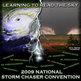
Denver will host the 11th annual National Storm Chaser Convention from February 13th to February 15th.

The 11th annual National Storm Chaser Convention hits town this weekend as some of the nation’s premier storm chasers converge on Denver.  Whether you are a seasoned chaser or just someone with an interest in the weather, this is an extraordinary opportunity to mingle with and hear from some of the biggest names in severe weather.  The event is organized every year by two of the biggest names in storm chasing – Roger Hill and Tim Samaras.

Held at the Red Lion Inn in Parker, the event kicks off Friday night with an ice-breaker and a chance to mingle with other weather enthusiasts.  Saturday morning the event starts in earnest with an extraordinary slate of speakers covering an array of topics.  Saturday night is the infamous video night where videos and photos from last year’s record setting year of tornadoes are sure to play a big part and Sunday the convention continues with additional speakers. 

Some of the speakers this year include:

Also notable, the National Weather Service will be holding a free storm spotter training session Sunday afternoon.  These are a great way to learn much more about severe weather.  Click here to learn more about storm spotter training and what it involves.

You can learn more about this great event and see the complete agenda on the convention website at www.chaserconvention.com.  

Here’s a little storm chasing video to get you pumped up for the event:

A look at Super Bowl weather history and some interesting tornado statistics for it

The biggest sporting event of the year is of course the Super Bowl and no doubt this year’s matchup between the Pittsburgh Steelers and the Arizona Cardinals is sure to be no different.  Super Bowl XLIII will be held in Tampa Bay, Florida and the weather forecast is looking to be just about perfect – see our game day forecast below.

What about Super Bowl’s in the past?  Was there ever any notable weather during the big game?  You bet there was.  Here are some fun facts (courtesy wx-man.com):

  • 17 of 42 Super Bowls played indoors
  • 16 of 42 Super Bowls had a trace or more of rain nearby
  • 2 Super Bowls had snow on game day (1982,2006)
  • 1 Super Bowl played during an ice storm (2000)
  • Warmest high temperature of 82° (1973,2003)
  • Coldest high temp for dome game 16° (1982)
  • Coldest high temp for non-dome game 49° (1985)
  • Wettest Super Bowl .92 inches (2007)
  • Outside games with high wind gust (1980, 1984, 1989,2007)

You will notice there isn’t really any mention of severe weather in those statistics. The NFL has been pretty fortunate on that front with nothing particularly notable – rain always seems to be the biggest threat. 

For a more in depth look at severe weather in February in Florida, the Super Bowl forecast and some interesting tornado statistics, please visit our Examiner.com story.

For all the details, read the rest of this story on our Denver Weather Examiner page. Examiner.com - Get inside Denver weather 

Storm Chasers premieres tomorrow night – New promo video released

Our favorite show, Discovery Channel’s Storm Chasers, premieres its second season tomorrow, October 19th.  We of course have touted this show before and cannot say enough good things about it.  The new season chronicles the tornado hunters’ as they chase storms across the plains this past summer.  The season was record breaking in the number of tornadoes and the number of deaths and the Storm Chasers team was right in the thick of it. 

Be sure to check out the show if you can.  Here is a new trailer to help get you excited.

Discovery Channel’s Storm Chasers to premiere October 19th

StormChasers
Discovery Channel's Storm Chasers

Just announced!  The Discovery Channel’s Storm Chasers second season will premiere on Sunday, October 19th.  For those that haven’t seen this show before, it is absolutely incredible as you follow a group of chasers trying to – literally – drive into a tornado.  As you know, the 2008 tornado season was one for the record books and the Storm Chasers team was right in the thick of it.  I will be watching with great interest as they spent a lot of time in north central Kansas right where my family is from. 

Continue reading Discovery Channel’s Storm Chasers to premiere October 19th

Back from vacation and storms on the plains!

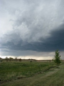
The storm approaches!Your intrepid Weather Examiner is back from vacation, relaxed, tanned and ready for summer!  What makes a good vacation for a weather geek?  Severe storms of course and I saw a doosy while in northeastern Colorado last week. 

Weatherwise my vacation started out pretty boring with mild days, cool nights and I suppose what most people would consider beautiful weather.  Last Friday started out much the same as the week with a calm, beautiful day on the eastern plains of Colorado but it is after all severe weather season and the chances of something brewing over a week are pretty good. 

By the mid-afternoon, more clouds started to roll in and by late afternoon, I was watching a storm cell with great potential develop to the northwest of me.  Soon the weather radio was beeping warning of a Severe Thunderstorm Watch being issued for my location and that was upgraded to a Warning before too long. 

Now we\'re talking!  Getting dark at 5:00 in the afternoon!Soon those clouds started to darken and spots of green were showing – sure signs of something major brewing.  A band of rain was clearly visible and moving our way.  A quick check of the weather radar software on my laptop showed great potential with the cloud tops exploding over 30,000 feet above.  Before long the rain started mixed with a touch of pea sized hail.  That rain got pretty heavy and the wind was getting pretty vicious.

Even a junior weather forecaster can tell there is trouble on the radar!Being in an RV in severe weather is not always the wisest place but I was pretty confident we were okay although we did have a plan to escape to more secure shelter about 75 yards away. After dumping a good inch of rain in less than 20 minutes the storm passes. However, that same storm cell did spawn a tornado 10 miles to the southeast after it passed me. Even more notably, the cell was so powerful, it continued churning out severe weather for an additional 90+ miles before disappating!  
 
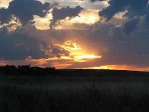
After the storm - a beauful sunset on the plains.In the end, having the one day of severe weather while on vacation made it pretty danged fun!  The desire to chase the storm cell was strong but my better half would probably not have approved me leaving the family behind at that point.  🙂

Windsor Tornado Officially Rated as EF3

The National Weather Service has completed their tornado assessment of the Windsor tornado and determined the twister was rated an EF3 on the Enhanced Fujita scale.  See below for details and here for a map of the path the twister took

PUBLIC INFORMATION STATEMENT…UPDATED…
NATIONAL WEATHER SERVICE DENVER CO
430 PM MDT FRI JUN 6 2008

..WELD COUNTY TORNADO OF MAY 22 2008 RATED AN EF3 TORNADO…

On Thursday May 22 2008 a wide and powerful tornado swept north northwestward for 34 miles from northeast of platteville in Weld County at 1126 AM MDT to 7 miles east northeast of Fort Collins in Larimer County at 1216pm MDT.   The National Weather Service tornado damage assessments conducted on Friday May 23rd and Saturday May 24th documented large areas of damage.  On the enhanced Fujita scale there were pockets of EF3 damage especially near the Missile Silo Park Campground west of Greeley and to homes and businesses in eastern Windsor.  Wind estimates in the heavily damaged areas were as high as 130 to 150 mph. 

The tornado was as wide as one mile at times along its path.  There was one fatality and 15 to 20 injuries.   Damage estimates are not finalized, but preliminary numbers from FEMA are 850 homes damage, with nearly 300 homes signficantly damged or destroyed.  Privately insured damages total 174 million dollars…and the Poudre Valley Rural Electric Association reported one million dollars of damage to electric transmission facilities.  

One question frequently asked is how unusual was this event.  Certainly it was not unusual in time of year (May and June are the peak tornado months in Colorado).  It was not unusual in location (more tornadoes are reported in Weld County than any other county).  It was slightly earlier in the day than normal, as we usually see tornadoes in the mid afternoon to early evening.  The track was longer than most, the tornado was moving fastern than most,  and a track moving north northwest is very unsusual.  Since 1950 there have been a total of 20 tornadoes of f3 and higher within Colorado.  This was the second f3 tornado reported in weld county since 1950.   On May 15, 1952 an F3 tornado injured 5 people within the county. 

For reference…the Enhanced Fujita Scale classifies tornadoes into the following categories:

EF0…wind speeds 65 to 85 MPH.

EF1…wind speeds 86 to 110 mph.  

EF2…wind speeds 111 to 135 mph.

EF3…wind speeds 136 to 165 mph. 

EF4…wind speeds 166 to 200 mph. 

EF5…wind speeds greater than 200 mph.