Tag Archives: weather record

Interactive map of snowfall totals across northeastern Colorado, February 2-4, 2012

Thornton residents have begun digging out from the major winter storm that deposited an extraordinary amount of snow on the city.  In the end, the storm will go into the record books as the biggest February snowstorm in Denver history.

Here is Thornton we recorded 13.8″ of snowfall and that was actually one of the lower totals across northeastern Colorado. It was however our biggest snowstorm since October 2009.

As officially recorded at Denver International Airport, Denver recorded 15.9 inches of snow from the storm system.  This handily broke the old single storm February record of 14.1 inches set in 1912.

Further, February 2012 now enters the history books as the 10th snowiest February ever recorded in Denver. With more than three weeks to go, it is possible we will climb the top 10 list even further.

The 12.5″ DIA saw yesterday set a new single day record for February 3rd beating the old record for the date of 9.5″ set in 1932. This also is the biggest single day snowfall total ever recorded in Denver during February.

For more details on Denver’s records, check out this story on Examiner.com.

Examiner.com slideshow: Record-setting snowstorm buries Denver and northeastern Colorado

Below is an interactive map of the snowfall reports from across eastern Colorado.  You can also click here to view a larger version.

  • Stay up to date with Thornton’s weather: ‘Like’ us on Facebook, follow us on Twitter and add us to your Google+ circles

View map on GeoCommons

Time lapse video of Thornton’s February 2012 snowstorm

The snow has moved out and the sun will be shining soon as residents begin digging out from a record-setting snowstorm.  Here is Thornton we recorded 13.8″ of snowfall and that was actually one of the lower totals across northeastern Colorado. It was however Thornton’s biggest snowstorm since October 2009 when we recorded 14.1″ from a late month event.

Snow began falling Thursday evening and continued through the night, all through the day Friday and into Saturday morning.  By this morning most of the metro area was only seeing a few flakes falling and by the end of the day the sun will return.

Below is a time lapse video from our east facing webcam.  It covers from 4:00pm on Thursday, February 2 to 6:00am on Saturday, February 4 compressing that period into a little more than one minute.

Also see the Examiner.com slideshow: Record-setting snowstorm buries Denver and northeastern Colorado

  • Stay up to date with Thornton’s weather: ‘Like’ us on Facebook, follow us on Twitter and add us to your Google+ circles

Denver sets 24 hour precipitation record for July 13; Closes in on top 10 wettest Julys

Record Rain
Denver easily broke the 24 hour precipitation record for July 13th.

It is readily apparent that July has thus far been a wet month given that we have seen eight straight days of thunderstorms.  Yesterday the storms set a record for precipitation and Denver is on pace to make the month one of the wettest Julys on record.

Out at Denver International Airport yesterday, 1.03” of precipitation was recorded.  This set the record for the date easily besting the old record of 0.45” set in 1993.

Here in Thornton we recorded 0.45” yesterday so a good bit less than out at the airport but still a decent shot of precipitation.

This brings Denver’s official total to 3.19” for the month so far. Average for the entire month of July is 2.16” so we are far ahead of that.

Number 10 on the ‘top 10 wettest Julys’ occurred in 1985 with 3.71”.  Given the fact that the forecast continues to contain daily thunderstorms for the foreseeable future, there is a good chance we will exceed that before the month is over.

Thornton is ahead of the game in comparison to DIA as we have recorded 4.52” so far this month.

Denver sets 24 hour precipitation record for June 20th

Record Rain
Denver easily broke the 24 hour precipitation record for June 20th.

It was a wet day in Denver yesterday and the statistics bear that one out.  The official Denver weather monitoring station at Denver International Airport recorded 1.05 inches of precipitation on June 20th.  This easily broke the previous record for the date of 0.50 inch set in 1938.

Here in Thornton we recorded a bit less but still a considerable amount – 0.87 inch.

The record setting rain in Denver does once again highlight the problems with having Denver’s monitoring station at DIA used for comparison to historical records.  The 12 mile move of the station in 1995 from its previous location has skewed Denver’s climate records.

With the event yesterday we see that the station in Denver City Park recorded no rain at all.  Had the National Weather Service logically choose to use this location, or the previous one at Stapleton, as the official source for Denver weather, no record would have been set.

For more on the problems with Denver’s climate records, see here:  Do Denver weather and climate records have an asterisk attached? (Examiner.com)

Record high temperature set for December 3rd

Not since Grover Cleveland was president has Denver had as warm of a December 3rd as today.
Not since Grover Cleveland was president has Denver had as warm of a December 3rd as today.Not since Grover Cleveland was president has Denver had as warm of a December 3rd as today.

If you looked at a thermometer late this morning or early this afternoon you might have found yourself wondering if the calendar that says it is December is correct.  Not since 1885 when Grover Cleveland was inaugurated as the 22nd president of the United States and  the Washington Monument was completed has Denver had as warm of temperatures on December 3rd as today. 

At 11:41am this morning the temperature at the official Denver weather station at Denver International Airport reached 69 degrees.  Thornton topped that slightly as we recorded 70.2 degrees at 12:13pm. 

As is often the case, the warmer temperatures have been brought on my strong winds.  Gusts this afternoon to 45mph are possible, particularly along the usual wind-prone areas in the foothills like   Highway 93 between Boulder and Golden.

The warmth will be short-lived however as those winds bring in a cold front later this evening.  Overnight and into tomorrow some areas of the Front Range may see a wintry mix of snow and freezing drizzle.  Highs on Saturday will only reach the mid to upper 30s.  For the complete local Thornton forecast click here.

Related (Examiner.com): Do Denver weather and climate records have an asterisk attached?

ThorntonWeather.com note: Some media outlets, including KMGH Channel 7, are incorrectly reporting that Denver hit a high temperature of 70 degrees today and broke the record.  This is incorrect. 

National Weather Service observations are initially reported in Celsius, rounded to the nearest whole degree – in today’s case, 21 degrees Celsius (70 degrees Fahrenheit).  However the true temperature is recorded to the nearest tenth of a degree.  Today’s actual high temperature was 20.6 degrees Celsius or 69 degrees Fahrenheit. 

Yet another reason to rely on ThorntonWeather.com for your weather news and information!  😉

That’s a big chunk of ice! South Dakota hailstone sets world records

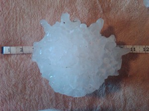
A massive hailstone with a diameter of 8 inches will likely set the record as the largest hailstone in terms of diameter and weight. (NWS)
A massive hailstone that fell in South Dakota on July 23rd set world records for diameter and weight. (NWS)

The massive hailstone that fell over rural South Dakota last week has officially set world records for its weight and diameter. According to the National Oceanic and Atmospheric Administration (NOAA) the chunk of ice easily eclipsed the previous record setter.

On Friday, July 23rd, severe weather rolled through northeastern South Dakota and Stanley, Jones, and Lyman counties. With it was massive hail so big it left holes in the ground the size of coffee cans. Les Scott, a ranch hand, recovered the now record setting stone afterwards.

NOAA’s National Climate Extremes Committee determined that the huge chunk of ice from the sky officially measured 8.0 inches in diameter and weighed 1.9375 pounds (1 pound, 15 ounces) setting records for both. It also measured 18.62 inches in circumference falling just short of breaking the record for that measurement.

The previous record holding hailstone in terms of weight fell on September 3, 1970 in Coffeyville, Kansas and weighed 1.67 pounds.

The stone that previously held the record for diameter measured 7 inches and fell in Aurora, Nebraska on June 22, 2003. That stone still holds the record for circumference having measured 18.75 inches.

While Scott froze it immediately, David Hintz, a meteorologist at NOAA’s Aberdeen weather forecast office, said in a statement some melting had probably occurred resulting in the official measurements being smaller than what the stone was when it first fell.

“Mr. Scott told me the area was littered with large hailstones and the largest had a greater diameter when he first found it. He immediately stored it and several others in his freezer, but a power outage caused some melting,” Hintz said.

South Dakota hail stone measures 8 inches in diameter – likely world record

A massive hailstone with a diameter of 8 inches will likely set the record as the largest hailstone in terms of diameter and weight. (NWS)

Hail is one of the most damaging weather events capable of doing thousands of dollars worth of damage to homes and vehicles and utterly shredding crops. Last week in South Dakota the mother of all hail stones appears to have fallen – a beast weighing nearly two pounds and measuring 8 inches in diameter.

On the evening of July 23rd severe weather rolled through the northeastern corner of South Dakota bringing with it a great deal of hail and some tornadoes. Near Vivian in Faulk County, the hail grew to proportions likely not seen anywhere else.

Ranch hand Les Scott watched the drama unfold as the hail pummeled the surrounding land. The stones were large enough that holes the size of coffee cans were left in the ground.

One particular hailstone caught Scott’s eye due to its sheer size. After retrieving it, he stuck it in his freezer. Word soon traveled about the massive chunk of ice and National Weather Service personnel made preliminary measurements placing the diameter at 8 inches with a circumference over 18 ½ inches.

Yesterday, the service returned to Vivian to transport the stone to the closest certified scale at the local post office to have it weighed. The scale tipped at an amazing 1.9375 pounds. It also had lost a bit in size dropping to 17 inches around.

Scott said the hailstone was quite a bit larger when he first found it, possibly as large as 11 inches in diameter. However, power was out in the area for six hours Friday and after he pulled it out to show various people, it lost some of its mass.

Continue reading South Dakota hail stone measures 8 inches in diameter – likely world record

Denver sets new record high temperature for March 30th

Denver set a new high temperature record for today, breaking a 131 year old record.

Following on last week’s wintry blast, residents of the Mile High City were anxious for spring-like weather and they received it today. Denver has officially set a new record high temperature for the date breaking a 131 year old record.

The National Weather Service reported that at 3:32pm the mercury reached 82 degrees at the official measuring station at Denver International Airport (DIA). This breaks the previous record of 81 degrees set in 1879. The service noted that Rutherford B. Hayes was our 19th president at the time.

Here at ThorntonWeather.com, we reached a high of 81.7 degrees at 4:01pm.

Denver’s newest National Weather Service station at Denver City Park recorded a high temperature today of 81 degrees. Many believe this station is the one that should be the official reporting station for the city as the station at DIA has been shown to be skewing Denver’s climate records.

Other area stations reported similarly warm temperatures. Longmont reached a high temperature of 83 degrees breaking its old record of 81 degrees set in 1986. On the Rocky Mountain Weather Network,  Arvada reached 84 degrees, north Denver 83 degrees, Littleton 81 degrees and Broomfield 83 degrees.

No tornadoes reported in February for the first time on record

For the first time since at least 1950, no tornadoes were recorded during the month of February. (Chris Foltz, NOAA)

While there was plenty of notable weather last month in the United States including the severe winter storms in the northeast, tornadoes were not one weather phenomena anyone had to worry about.

According to the National Weather Service, there were no twisters reported during February 2010 – the first time since record keeping began in 1950 that February did not have any. The previous low number of tornadoes in February was 2 in 2002.

Harold Brooks, a meteorologist with the National Severe Storms Laboratory, said the last time the United States went a calendar month without a tornado was January 2003. Through yesterday it has been 36 days since the last twister struck on the 24th of January in Tennessee.

Brooks cautions against reading too much into the statistic. He said it tells us, “Somewhere between a little and nothing at all.”

Most years that start out slow in terms of tornado events end average or below average Brooks said. However, he also points to 2003 when the year started out 45 days without a tornado but by the middle of May the season was above normal.

For the complete story including what Dr. Greg Forbes of the Weather Channel had to say, please check out the rest of the story on the Denver Weather Examiner.

Denver sets new record high minimum for November 12th

Denver broke the record high minimum temperature for the date yesterday.

The Mile High City has enjoyed some great weather this past week and one weather record has officially been set. Just before midnight last night, the temperature at Denver International Airport dropped to 45 degrees. This sets a new record high minimum for November 12th, breaking the old record of 44 degrees set in 1894.  Thornton however wasn’t near as warm as we had a low temperature of 40.5 degrees.

The warm weather pattern though is set for a big change this weekend as you can see in our forecast. Two systems will begin to impact the area, the second of which arrives Saturday afternoon and could bring a good deal of snow to the area. Get the details on the Winter Storm Watch here.

It is important to remember though that the National Weather Service moved Denver’s official measurements to DIA 14 years ago from the former Stapleton site. This has caused a major change in Denver’s climate and weather records. Data shows that DIA runs hotter on the highs, colder on the colds and records less moisture than what stations closer to Denver do. This has resulted in Denver’s historical climate records being skewed.

Some say Denver’s climate records have forever been altered due to the station move and as such any weather record should have an asterisk attached to it. For more on the controversy, be sure to read our Examiner.com investigative series:

Examiner.com Investigates
Do Denver weather and climate records have an asterisk attached?

Part 1 – Overview and history.

Part 2 – Data analysis. Is there a problem?

Part 3 – Solutions, conclusions and why you should care.

Data analysis slideshow.

November 12, 2009 – Denver gets new National Weather Service monitoring station