Tag Archives: weather record

October 2009 ends as second coldest and fifth snowiest on record

October 2009 in Denver was the second coldest and fifth snowiest October on record.

Most of the month of October was cooler than normal in the Mile High City and now that the month is over we see just how cold it was. Denver finished October 2009 with an average temperature more than 8 degrees below normal and had 9 inches more snow than what is normal for the month.

October 2009’s 42.9 degree average makes it the second coldest since record keeping began in 1873 – 136 years ago! re in Thornton we were actually slightly cooler with an average temperature of 42.0 degrees.  Only October 1969 was colder as that year Denver had an average temperature of a chilly 39 degrees.  He

Across the board temperatures for the month were well below normal. The average daily high temperature of 54.7 degrees was 11.3 degrees below the normal of 66.0 degrees. Low temperatures were similarly well below normal with an average of 31.1 degrees – 4.8 degrees below the normal of 35.9. 

Thornton was warmer for daytime highs than the Denver official temperatures as we averaged 55.6 degrees.  In terms of low temperatures, we were cooler having averaged 30.7 degrees. 

There's more to this story on the Denver Weather Examiner's site!What about the snowfall?  Denver finished with the fifth snowiest October on record.  Click here to get all the details on Examiner.com.

Why do we link to Examiner.com?  Click here to find out.

Denver ties high temperatures record for the date

Denver tied the record high temperature for the date today.

At 3:44pm today, the temperature at Denver International Airport reached 84 degrees.  This tied the record high temperature for October 18th set in 2003 and 1958.  The average temperature for this date is 68 degrees so we exceeded that by a large margin. 

From record setting cold last week to record setting warmth this week – you have to love Colorado weather! 

Was it really a record though?  Examiner.com investigates: Do Denver weather and climate records have an asterisk attached?

Here in Thornton we were actually a touch warmer reaching 85.9 degrees.  We have one more day of above normal temperatures ahead on Monday before we see a change that will bring cooler temps and possibly rain and snow.

Record setting cold may be on the way

As the Colorado Rockies return home to play game 3 of the National League Divisional Series against the Philadelphia Phillies, the weather could prove to be a tougher opponent than the opposing team. As we forecast early this week, a major blast of Arctic air will be arriving over Colorado tonight and will send thermometers plunging, possibly into record setting territory.

Over the next 48 hours, Denver could break three, very chilly records:

  • The record low temperature for Denver on the 10th of October (Saturday), the day of the game, is 25 degrees. That was set more than 100 years ago in 1905.  Tonight’s / tomorrow morning’s forecast low temperatures are expected to be in the low 20’s.
  • The record low maximum temperature for the 10th is 34 degrees, set in 2005. Tomorrow’s forecast high temperature is expected to be in the mid 30’s.
  • The record low temperature for the 11th of October (Sunday) is 22 degrees set in 1946. Current forecasts put the overnight low Saturday / Sunday morning as possibly hitting down to 17 degrees.

Of the three, it seems pretty likely we will break the first and the third record listed. The second one is a bit up in the air.

There's more to this story on the Denver Weather Examiner's site!For a detailed look at what the weather forecast holds for the Rockies and Phillies, check out our forecast at Examiner.com.

Record setting cold in Denver kicks off October

Cold weatherTwo days in a row Denver has set or tied record low temperatures. 

On Friday at 5:55am the temperature at Denver International Airport dropped to 26 degrees easily setting a new low temperature record for October 2nd. The previous record of 30 degrees was set in 1999 and also in 1959.  This was the first freeze of the season.  Thornton however remained above the freezing mark with a low of 33.1 degrees.

Following on yesterday’s record setting cold, the Mile High City tied a 109 year old low temperature record this morning. The temperature at Denver International Airport dipped to 31 degrees tying the record low for this date last set in 1900.  Unlike yesterday, Thornton was actually cooler than the official Denver temperature having recorded a low of 28.2.

The average date of Denver’s first freeze is October 7th so we are a bit ahead on timing. The earliest date Denver has received freezing temperatures is September 8th which occurred in 1962. The latest date was in 1944 when the mercury didn’t dip to freezing until November 15th.

For a look at Denver’s cold weather statistics click here.

NOAA: Summer 2009 was 34th coolest on record; thousands of low temp records set

Highlighting the cooler summer, thousands of record low temperatures were experienced in July 2009. (NCDC)

The National Oceanic and Atmospheric Administration (NOAA) announced this week that the summer of 2009 was the 34th coolest since 1895. Covering the months from June to August for the contiguous United States, the average temperature was 0.4 degrees below the 20th century average.

Emphasizing the lower temperatures experienced in the United States over the summer, a closer look at the statistics provides some telling information.

Over the three month period, stations reporting to the National Climatic Data Center (NCDC) showed 2,254 daily record low temperatures and 1,296 low temperature records were tied according to preliminary data. Similarly, 4,051 daily record low maximums were recorded and 1,501 records were tied across the nation during the summer.

July in particular was notably cooler than normal and the single month by itself counted for roughly half of the records set across the three month summer. For the month, 2,212 record low maximum temperatures were recorded and 737 were tied. 1,225 new record low temperatures were recorded and 657 records were tied.

There's more to this story on the Denver Weather Examiner's site!For all the details on the United States’ summer weather including NOAA’s summary and a look back at the country’s August weather, go to Examiner.com.

A new record low maximum temperature set & snow comes to the mountains

Denver has record setting cool temperatures and snow arrives in the Rocky Mountains.  Image courtesy Victor Lewis.
Denver has record setting cool temperatures and snow arrives in the Rocky Mountains. Image courtesy Victor Lewis.

While some parts of the nation experience record setting heat, on Thursday Denver had the opposite problem. The high temperature as measured at Denver International Airport reached a mere 64 degrees. This was two degrees below the previous record low maximum temperature of 66 degrees for this date set in 1925 and previous years. That is also an amazing 24 degrees below the normal temperature for this time of year!

Here in Thornton, we were even cooler than the official temperature on Thursday as the mercury climbed to a mere 61.3 degrees! 

The unseasonably cold weather has also brought an unusual sight to the Colorado mountains in July – snow! Some northern parts of the Rocky Mountains in the state above 12,000 feet received a couple inches of snow.

June 2009 is now the 2nd wettest Denver June

From the National Weather Service: June 2009 has moved into the second wettest June since Denver weather records began in 1872.  So far for June 2009, through June 26th, the Denver International Airport (DIA) has measured 4.86 inches of liquid (and there are still 4 more days left in June).  The 4.86 inches of water is 3.52 inches above normal through the 26th.  Last year, June 2008 had only measured 0.73 inch again through the same June time frame.

The wettest June on record for Denver was in June 1882 when 4.96 inches of moisture was collected in the rain bucket.

For the 2009 year so far, 10.38 inches of water has been measured at DIA which is a very impressive 2.51 inches above the normal through June 26th.   Last year in June, only 3.04 inches had been recorded through the same time frame.

Note:  The average Denver annual precipitation is 15.81 inches.

As always, we have to ask, do Denver weather and climate records have an asterisk attached?  Read our Examiner.com investigation to see why maybe they should.

Denver officially breaks high temperature record for this date

Denver officially broke the record high temperature for January 21st, reaching 71 degrees.

It’s official. As reported earlier this morning on our Examiner.com pages, we had a decent shot at breaking the all time record high temperature for this date and we have done it.  At 1:28pm today the temperature at Denver International Airport reached 71 degrees, breaking the old record of 70 degrees set in 1950.  Here in Thoronton we didn’t get quite that warm, “only” reaching a high of 69 degrees.

Thursday we will be a bit cooler and “only” reach 65 degrees – still 20 degrees above normal though.  Enjoy the next 36 hours or so though as Friday bring change – see our Examiner.com morning forecast here for details.

Get more local news and weather information on Examiner.com.

This article and many more are posted to the Denver Weather Examiner site.


Visit Examiner.com for more local Denver news and weather.

Record setting cold continues for Thornton and Denver

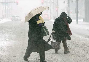
Erin Mooty tries to stay warm as she waits for a bus Monday.  Image courtesy Darin McGregor, The Rocky.
Erin Mooty tries to stay warm as she waits for a bus Monday. Image courtesy Darin McGregor, The Rocky.

The cold continues to hang on and in the process Denver managed to set one record and tie another in the last 24 hours.  This is of course on top of the two records set before that.

Yesterday the mercury at Denver International Airport only climbed to 2 degrees.  This smashes the old record low maximum temperature for the date of 19 degrees set way back in 1914.  Following up on that, this morning DIA fell to an official low of 8 degrees below zero.  This ties the record low temperature for December 16th last set in 1897. 

Today we have good news and bad news.  The good news is that the snow we were expecting didn’t materialize on the Front Range thanks to downslope winds.  That at least saves adding to the misery of the cold.  The bad news though is that this cold is far from over.
 
Tuesday we will remain quite cold and only reach 18 degrees here in Denver.  The mountains will continue to get pounded by snow, particularly the southwestern areas where two to three feet could fall.  A number of advisories have been posted for the southwestern and central mountains so if you are heading to the hills, you may want check the conditions before you go. 

Wednesday, Thursday and Friday there is a chance we could see temperatures above freezing but it won’t be by much – maybe 33 or 34 degrees.  A chance of snow will remain in the forecast for the foreseeable future as well although there won’t be much if it does snow. 

Come the weekend though, the “heat wave” looks to come to an end as an upper level trough that is sitting over the Pacific coast right now moves into the area.  With it our chances of snow increase and the temperatures could drop to the low 20’s Saturday, Sunday and Monday. 

The best piece of advice?  Bundle up and stay inside if you can!  

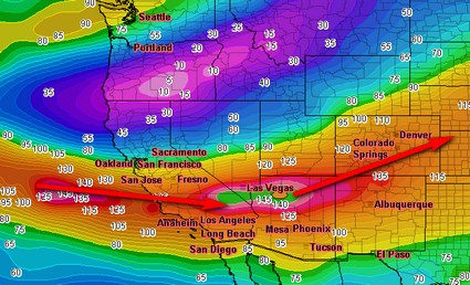
Where’s this weather coming from?  The jet stream is currently pulling in moist air from the Pacific and sending it right over Colorado.  This in turn is pulling down cold air from the north.  The image below helps you see what is going on.

The jet stream is currently speeding over southern Colorado.

Denver breaks 107 year old record

Denver officially broke the record for the coldest temperature recorded on this date.

Updated 12/15/08 @ 3:30am:

It’s officially cold as heck now!  The cold front has caused the mercury to plummet across the Front Range and we have officially set two new low temperature records.

At 5:52pm on Sunday, December 14th, the temperature at Denver International Airport dropped to -15 degrees.  That broke the old record of -14 degrees for this date set way back in 1901.  The mercury continued to drop and bottomed out at -18 degrees at 6:35pm.

The morning of the 15th has started with a new record low temperature as well.  At 12:00am the temperature was -13 degrees, breaking the old record for the date of -6 set in 1951.  The temperature is still dropping so that record will undoubtedly get even colder. 

It is important to note that prior to DIA opening, temperatures were measured at the old Stapleton site and prior to 1950 they were measured downtown.   That makes a 15 mile distance between where temperatures are measured now and where they were prior to March 1995.  Those 15 miles can accont for large differences in temperature so the record setting temperatures needs to be balanced with that knowledge as in some ways you are comparing apples and oranges.  Click here for a bit of history on the Denver Forecast Office.

Original posting:

We can officially say it is cold now.  The National Weather Service has reported that at 5:52pm the temperature at Denver International Airport dropped to -15 degrees.  That breaks the old record of -14 degrees for this date set way back in 1901. 

Thankfully here in Thornton we haven’t gotten that cold.  At 7:00pm Sunday night it is currently -6.2 degrees.  We will get down to -11 tonight and then only climb to 18 Monday.  Bundle up!

It is important to note that prior to DIA opening, temperatures were measured at the old Stapleton site (and before that downtown).   That makes a 15 mile distance between where temperatures are measured now and where they were prior to 1994.  Those 15 miles can accont for large differences in temperature so you have to take these new records with a grain of salt.