Tag Archives: winter weather

City of Thornton offers residents winter weather preparedness tips

The City of Thornton wants residents to be prepared for the coming cold weather.

As we have been covering all week, by the governor’s declaration this is Winter Weather Preparedness Week in Colorado.  The City of Thornton has gotten on board with information to help the city’s residents prepare themselves for the coming season.

Thornton has become much more ‘weather aware’ in recent years and we applaud them for that.  Weather has a direct impact on everyone’s lives, too often with deadly effects, and it is important that people are aware of the dangers it presents.

The new page on the city’s website provides some great resources for residents.  On the page you will find information from the National Weather Service, a great document prepared by the Thornton Fire Department about winter safety and information about the city’s snow removal plan.

We do have to make note of a couple of things on the page.

First, there is no link to ThorntonWeather.com.  We are not affiliated with the city in any way however we are the only source of truly local weather news and information.  The city must be careful of who they put out there as a recommended resource but ThorntonWeather.com is well-established having been around for more than five years and being well known and highly regarded in the community.  We pride ourselves on the wealth of information we provide, an amount that far surpasses any other.

Second, it is somewhat ironic that one of the links provided on the city’s page is for Emergency Alert Information from the Colorado Division of Emergency Management.  This is a great resource page but as we have pointed out repeatedly, neither the city nor Adams County has any sort of emergency alert system.  This is a serious deficiency that the city has chosen not to address at this time.


Denver suffering through worst snow season in more than 125 years

Denver is having a pitiful snow season - the third worst in the city's history. (Denver Weather Examiner)

March 31 was the last day of what is historically Denver’s snowiest month but like every other month this season, it fell dismally short in terms of the amount of snowfall.  In fact, as it stands now, the Mile High City and Thornton area experiencing their third worst season of snow since record keeping began.

In a normal snow season, through the end of March, Denver historically averages 51.3 inches of snow – a healthy total needed for water supplies, irrigation and to help keep the wildfire danger down.

For the 2010 to 2011 season we are far behind that mark.  As of yesterday Denver has recorded a paltry 20.6 inches of snow this season at DIA; a total more than 30 inches below normal.  Only two other seasons have seen lower snow totals at this point in the season since record keeping began in 1882 – and those were more than 125 years ago.

For the season Thornton has fared worse than the official Denver totals as we have recorded a mere 19.7 inches (click here for the latest totals).  Stapleton has recorded 22.8 and Denver City Park has fared the best with 26.8.

Only one month in this snow season has Denver seen at or above normal snowfall.  That occurred in January when we recorded 8.0 inches of snow versus the average for the month of 7.7 inches.

By comparison, the Mile High City’s two snowiest months – March and November respectively – saw very little snowfall.  In March a mere 2.5 inches fell in contrast to 11.7 inches on average.  November 2010 saw only 1.5 inches of snow versus the November average of 10.7 inches.

The long range climate forecasts from the National Weather Service predict continued drier and warmer than normal weather for the month.  April is however historically our third snowiest month so there may be hope, especially given the history of the two seasons on record that were worse than this one.

During the 1883 to 1884 season, April brought 18 inches of snow and the 1884 to 1885 season saw an astounding 32 inches of snowfall in the month.  While both snow seasons finished below average, they made up a lot of ground in 30 days.

We can only hope that this season follows suit or we will be in for a very dry – and dangerous – summer.

For more information:

NASA satellite reveals January had fifth largest snow cover in past 45 years

NASA satellite imagery reveals that at one point in January 2011 the nation saw its fifth largest snow cover extent. Click the image for a larger view. (NASA)

How much snow has fallen this season in Colorado all depends on where you are.  The high country has continued to see snowfall far in excess of normal while here on the Plains we remain mostly dry.  For the nation, a new NASA satellite image reveals that 71 percent of it was covered in snow at one point last month.

The new image (right), taken by NASA’s Terra satellite using its Moderate Resolution Imaging Spectroradiometer (MODIS), reveals a snow covered contiguous United States in January.

The image uses false colors to show the snow extent and the length of time it was on the ground.  White areas were completely covered with snow for most of the month whereas the pale green areas had snow for part of the month or were only partly snowy.

On January 12, 71 percent was covered in snow – the fifth largest amount of snow cover in the past 45 years.  In fact, 49 of the 50 states had snow thanks to a significant winter storm that pummeled the Gulf Coast states with Florida being the only hold out.

Despite the expansive snow cover, the National Climatic Data Center said that January 2011 was the ninth-driest January in the United States since 1894.  Further, while snow reached the Gulf Coast states, the southern half of the nation has been very dry with a large area from stretching Arizona to Virginia considered in various stages of drought.

Eastern Colorado is now seeing areas of moderate to severe drought as the lack of snowfall we have seen takes its toll.  In Denver we have recorded only 18.1 inches of snow so far this season – 21.5 inches below what we would normally see through the end of February.  Thornton has barely fared better recording 18.5 inches so far.

From Examiner.com:

Related:

The Big Freeze – Snow and Arctic cold to be main Thornton weather feature

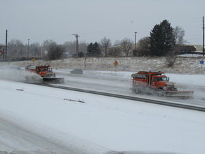
CDOT snowplows on I-25
CDOT snowplows work on I-25 near 104th Avenue Monday afternoon. Arctic cold will be a major hazard as wind chills could dip to 35 degrees below zero over the next 36 hours. (ThorntonWeather.com)

Storm update, 4:30pm – The thermometer only knows one way through the rest of today and tonight – down!  Thus far Thornton has dipped to 6 degrees with wind chill values around -3 and it is far from done dropping.

The National Weather Service has modified the weather warnings / watches for the next 12 hours or so.  The Winter Weather Advisory for snow will continue through midnight.  New however is a Wind Chill Warning that will be in effect from midnight through 6:00am Wednesday.

In terms of snow we will continue to see a pretty steady stream of light snowfall through the extended period but accumulations will be light.  Most areas will see a couple inches additional accumulation with higher amounts south and west in the foothills and along the Palmer Divide. 

The cold continues to be the real story.  Temperatures overnight will be dropping to five below zero with some places possibly getting even colder.  Couple the cold air with gusty winds to 25 mph and wind chill readings will be between 15 and 35 degrees below zero. 

These temperatures will be very dangerous for anyone caught outside in the cold.  Hypothermia and frostbite can settle in very quickly and everyone needs to be aware.

Roads continue to be icy and snowpacked and the afternoon and morning rush hour are going to be rough around the metro area.  Drivers should exercise extreme caution.

All Thornton area school districts have announced they will be closed on Tuesday including Adams 12, Adams 14, Adams 50, Mapleton, and Brighton 27J.

Continue reading The Big Freeze – Snow and Arctic cold to be main Thornton weather feature

Thornton set to get a taste of the Arctic; Winter Weather Advisory issued

A Winter Weather Advisory will go into effect at 6:00am on Monday as snow and bitter cold arrive. (ThorntonWeather.com)

A major winter storm is set to impact nearly two thirds of the nation starting tomorrow including Thornton and the rest of northeastern Colorado.  The National Weather Service has issued a Winter Weather Advisory for our area warning of blowing snow and dangerous cold.

The service is warning of total snow accumulations of 3 to 7 inches for the event from tomorrow morning through Tuesday.  Snow is expected to start lightly on Monday morning then increase in intensity in the afternoon and continue overnight into Tuesday morning. 

Arctic cold will be a prominent feature of this system sending the mercury plummeting into areas that present a very real danger to people and property.  Monday will see temperatures at about 26 degrees at 6:00am but then decreasing continually throughout the day and overnight when it will drop below zero. 

Tomorrow’s afternoon commute and the Tuesday morning commute are likely to be rough ones so you will want to plan accordingly. 

Tuesday’s high temperature will struggle to even get above zero and overnight temperatures on Tuesday could drop all the way to 15 degrees below zero.  Wednesday will warm only slightly with highs of around 10 degrees.

Continue reading Thornton set to get a taste of the Arctic; Winter Weather Advisory issued

Slammed again – Northeastern U.S. gets another snowstorm while Thornton waits

Snowfall totals from the latest snowstorm to strike the northeastern United States. (Examiner.com)
Snowfall totals from the latest snowstorm to strike the northeastern United States. Click the image for a larger view. (Examiner.com)

Yet another major snowstorm pummeled the northeastern United States yesterday and last night, their third in less than a month.  Snow totals in many areas from this single storm have far exceeded what Denver has received for its entire snow season thus far.

Snow began falling on Wednesday snarling evening commutes from Virginia to New York and picked up in intensity overnight. 

Snowfall totals this morning include 18.9 inches at Newark Airport, 19.0 inches at Central Park and 15.1 inches in Philadelphia (click here to view the latest totals from across the region).  These all dwarf Denver’s official seasonal total thus far of 12.1 inches!

Even President Barack Obama was not immune to the storm as Marine One, the presidential helicopter, was grounded due to the weather Wednesday.  Returning from a trip to Wisconsin, the president took a motorcade back to the White House instead and spent an hour stuck in traffic. 

As many as 400,000 residents across the northeast are without electricity as the unusually wet snow wreaked havoc with the utilities.  Public schools are closed Thursday and many government offices followed suit with the only exception being emergency personnel.

Slideshow: Northeastern U.S. battered by another snowstorm New York area airports shuttered Wednesday causing flight delays and cancellations across the nation.   The FAA reports that most should open late this morning or this afternoon.

Virtually every major city has reported seasonal snowfall totals so far this year far in excess of normal.  New York City, Boston, Worcester and Providence all have accumulated more than a foot of snow above average. 

Click the image to the left to view a slideshow of images of the snow around New York City (Examiner.com).

This story was originally featured by the Natural Disasters Examiner on Examiner.com.  Remember that by visiting there you are supporting ThorntonWeather.com.

Wednesday’s snowstorm in 10 seconds or less

To say today’s snowstorm was a fast mover doesn’t do it justice.  The storm hit fast and furious and many doubted our forecasts for only light snowfall.  But, as quickly as it arrived the winter storm departed and the event was over by nightfall.

In a span of three hours or so Thornton received 1.2 inches of snow.  Of course it is a bummer to have to withstand the traffic problems caused by a storm that brought so little.  To top it off we now have to wash our cars which hadn’t been clean but for a few days.  Not much return for the hassle, even if we need the moisture.  🙂

The time lapse video below captures the entire event from start to finish and does it in about 9 seconds.

Avalanche keeps US 40 over Berthoud Pass closed; Search continues for missing snowboarder

CDOT crews work to clear an avalanche that has covered US 40 over Berthoud Pass. (CDOT)
CDOT crews work to clear an avalanche that has covered US 40 over Berthoud Pass. Click to view a larger image. (CDOT)

With hurricane force winds and heavy snowfall conditions in Colorado’s high country have been treacherous in recent days.  The search continues for a snowboarder that disappeared at the height of the storm and an avalanche keeps US 40 over Berthoud Pass closed.

The winter storm that struck yesterday brought with it winds to 99 mph near Loveland Pass and 85 mph near one of the Breckenridge Ski Area mountains.  The strong winds coupled with the snow that fell has created dangerous avalanche conditions in the high country.

US 40 over Berthoud, US 6 over Loveland Pass and Interstate 70 were all closed at some point over the past 36 hours.  I-70 has reopened but US 6 remains closed due to adverse conditions and avalanche control work. 

While the skies have cleared over US 40 and Berthoud Pass, the massive avalanche has forced the highway to remain closed.  Images released by the Colorado Department of Transportation (CDOT) show the highway completed covered from the slide.  No ETA has been provided as to when the pass will open. 

  • Editor’s note – CDOT reports Berthoud Pass opened at 5:40pm. Read on though for for other information.

Search and rescue teams from Grand County were also combing the Berthoud Pass area for a missing snowboarder and his dog although it is unknown if that is in the same location as the avalanche.   26-year-old Jeffrey Miller, his dog and a companion were separated at the height of yesterday’s storm.  The severe weather conditions have limited the search for Miller. 

The snow from the avalanche has completely covered US 40 over Berthoud Pass. Click the image for a larger version. (CDOT)

An Avalanche Warning is in effect for the Front Range mountain areas as well as the Vail and Summit County Areas.  The Colorado Avalanche Information Center warns of high danger levels saying, “Natural and human-triggered slides are likely in avalanche terrain where significant storm and wind-blown snow has accumulated.”  Most other areas in Colorado have been given a “considerable” danger rating for avalanches. 

Colorado’s weather this winter has been a story of two halves.  The eastern half of the state and the Denver area have been warmer and much drier than normal.  The western half of Colorado however has had a great deal of snow with some basins reporting more than 130% of normal snowpack.

More on ThorntonWeather.com:

NASA satellites capture images of snow across the U.S.

Snow cover across Colorado as imaged by NASA satellites on January 12, 2011.  View a larger image below and images of snow elsewhere in the nation.
Snow cover across Colorado as imaged by NASA satellites on January 12, 2011. View a larger image below and images of snow elsewhere in the nation.

Snow cover across the lower 48 states jumped to more than 70% in recent days as a number of snowstorms dumped a blanket of white.  NASA satellites took some extraordinary images of not only Colorado but also the South and the northeastern U.S.

Here in Colorado our recent storm brought nearly 6 inches of snow to Thornton and deposited a pretty solid layer across most of the state.  Warm weather today and in the coming days will make short work of it though, particularly on the eastern half of the state.

In the southern U.S., a powerful winter storm on Monday brought rare snow to states along the Gulf of Mexico.  For a region accustomed to more mild conditions the storm presented a major challenge for residents.

Little Rock, Arkansas reported 5.6 inches of snow, Atlanta 3.0 inches and 7.0 inches fell on Tupelo, Mississippi, Asheville, North Carolina and New Boston, Texas.  Adding to the problems was ice which coated some places up to an inch and a half thick.

The same storm system that wreaked havoc in the south moved to the northeast and brought snow from the Mid-Atlantic to New England.  The region was buried by a major snowstorm right after Christmas and while this storm wasn’t near as bad, it added to the misery

The images below were taken yesterday by NASA’s Terra and Aqua satellites and are impressive testaments to the powerful winter weather.  For more on all of these storm systems, be sure to visit the Natural Disasters Examiner.

Continue reading NASA satellites capture images of snow across the U.S.

Winter storms take their toll – Snow covers 69% of the lower 48 states

National snow cover map as of January 11, 2011.
Snow now covers nearly three quarters of the lower 48 states and 47 of the 48 have at least some snow. (NOAA)

For much of the lower 48 states of the United States the 2010 to 2011 winter season has been a rough one.  Blizzards and snowstorms have stretched into the Deep South and this morning data shows that nearly three quarters of the nation is covered in snow.

The latest analysis from NOAA’s National Operational Hydrologic Remote Sensing Center shows 69.4% of the lower 48 states covered in snow as of this morning.  This is a significant increase over the 33.1% cover seen in December and bests the previous snow season’s highest number.

Perhaps most interesting is that 47 of the lower 48 states and 49 of all 50 states including Hawaii have at least some snow with the only exception being Florida.  Even the Deep South reaching nearly to the Gulf of Mexico is covered in a blanket of white today after ice and snow pummeled the region yesterday.  Early this morning only five of the 48 did not have some sort of a winter weather warning or advisory in effect.

A snowstorm that started in the South before Christmas moved up the East Coast and left record-setting snow totals in its wake including in New York City.  The same storm that struck the South yesterday now has its sights set on the same area from the mid-Atlantic to New England. 

Continue reading Winter storms take their toll – Snow covers 69% of the lower 48 states