Tag Archives: winter weather

Is Denver Halloween snow fact or fiction?

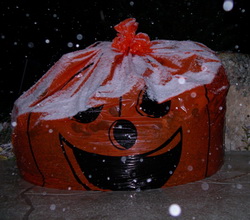
Snow on Halloween?  Popular belief is that we seem to have a lot of snow when the trick or treaters are out on the street.
Snow on Halloween? Popular belief is that we seem to have a lot of snow when the trick or treaters are out on the street.

Conventional wisdom in the Denver area is that it always seems to rain or snow on Halloween.   I know as a kid growing up here it seemed like Mother Nature always put a damper on our trick or treating. 

But, is there any truth to this urban legend?  Or is this just one of those times where our memory doesn’t serve us quite right? 

This year it looks like we have nothing to worry about but  the National Weather Service has been kind enough to compile weather statistics just for Halloween.  As it turns out, the thought of snow and rain on Octboer 31st isn’t just in our minds! 

Get all the details in our Denver Halloween statistics and info page!  Click here!

Will it snow this Halloween?  Get the latest forecast here.

Winter-like storm brings more than 3 inches of precipitation to Thornton

As we begin to dry out from an incredibly wet April storm, we can take a look at some of the numbers from the three day event.  Being on the warmer east side of the Denver area, Thornton did not receive a tremendous amount of snow as temperatures here simply remained too warm.  What we did get though was rain – and LOTS of it. 

ThorntonWeather.com measured 3.06 inches of precipitation – the most we have recorded for a single weather event since we went operational in October 2006.  Friday was the wettest of the three days with 1.86 inches recorded – not a single day record for ThorntonWeather.com but still a great amount for our arid climate.  The steady and more or less constant rain brought much needed moisture and helps to make up for what has been a dry snow season thus far. 

Denver did officially set a record for Friday when 1.16 inches of precipitation was recorded at Denver International Airport – the most ever on April 17th.  The old record was 1.00 inch set in 1920. 

While we remain well behind normal on snow for the season, for the calendar year thus far, the storm put Denver ahead of the curve on precipitation.  Normally by this date we would have had 3.36 inches of precipitation.  Since January 1 Denver has now recorded 3.61 inches, 0.25 inch above normal, so that is definitely good news. 

As we mentioned, Thornton did not receive a lot of snow from this event.  We recorded 3.1 inches total as the rain / snow mix we saw at many times resulted in what snow did fall being compacted by rain immediately thereafter.  Other areas of the Front Range however, those primarily west and south, were a touch colder and received a great deal of snow.  A quick look at a few of the snow totals from the event:

  • Pinecliffe – 52 inches
  • Rollinsville – 51 inches
  • Nederland – 37 inches
  • Blackhawk – 36 inches
  • Evergreen – 29 inches
  • Cherry Creek Dam – 15.3 inches
  • Parker – 14 inches
  • Highlands Ranch – 13.4 inches
  • Boulder – 10 inches
  • Broomfield – 9.3 inches
  • Arvada – 8.8 inches
  • Denver, Stapleton – 3.3 inches
  • ThorntonWeather.com – 3.1 inches
  • Denver International Airport – 2.6 inches (Denver’s official site)

All of that moisture and a coming week of temperatures in the 70’s are sure to truly start greening up the landscape.  It won’t be long now for sure and you will be mowing the lawn!

Denver blizzard moves out as the digging out begins

Thornton begins digging out from the March Blizzard of 2009.
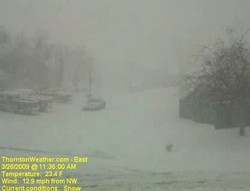
Thornton begins digging out from the March Blizzard of 2009. This image is from our webcam as the storm really began in earnest just before noon.

The sun is already beginning to shine in the wake of Denver’s biggest snowstorm of the 2008 – 2009 winter season.  The storm was also Denver’s biggest since December 2007 when a series of storms dumped more than 30 inches on the city.  While the snow brings much-needed moisture to the parched Front Range, it was a stark contrast to the 70 degree temperatures of just a few days ago. 

Here is Thornton we received 11.4 inches of snow from the storm which increases our season total to 38.1 inches.  While yesterday’s snow helps, that is still barely half of what we average in a season so much more is needed if we want to make up lost ground.

Cold and wind were also part of the story.  Thornton’s high temperature yesterday was 35 degrees but that occurred before 11:00am.  Once the storm arrived, the mercury plummetted 15 degrees and we saw temperatures in the mid-teens.  Winds are what made the storm a blizzard and we had plenty of that with gusts to 33 mph.  The cold temperatures and wind coupled to give us wind chills in the low single digits and Thornton actually recorded a maximum wind chill of 1.3 degrees below zero.

If you haven’t seen it yet, check out these two Thornton weather stories from the blizzard:

For a complete recap on Denver’s March Blizzard of 2009, see our story on Examiner.com.

For all the details, read the rest of this story on our Denver Weather Examiner page. Examiner.com - Get inside Denver weather

Thornton’s March Blizzard 2009 – Time lapse videos

The March Blizzard of 2009 is winding down and it gives us a chance to look at all that happened in the last 36 hours or so.  One of the neat things to look at is the 24 hour time lapse video from yesterday.  Check out the video from our two webcams:

East Webcam Time Lapse – 3/26/09


West Webcam Time Lapse – 3/26/09

Major snowstorm starts to hit Thornton, Blizzard Warning issued

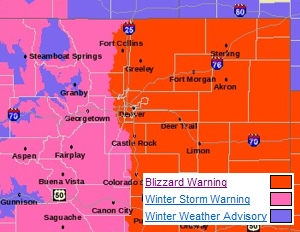
A Blizzard Warning is in effect for all of eastern Colorado, including Thornton.

Thornton and Denver are preparing for what will be its biggest snowstorm of the season today as the National Weather Service has now issued a Blizzard Warning for all of eastern Colorado.  The major storm we had been watching in recent days is now arriving over the Front Range and snow is starting to fall and will become widespread by 7:00am.  Initially the snow will melt as it hits the ground but as it gets heavier, it will begin to accumulate.

March is our snowiest month and this is setting up to be a classic late winter / early spring storm with lots of Pacific moisture and a Canadian cold front dipping down from the north.  Winds are now starting to come out of the east and northeast providing the required upslope conditions that will slow the storm down and hold it over the Front Range.

Between noon and about 9:00pm the snow will be at its heaviest as will the wind which will cause significant drifting and road travel will become treacherous – the afternoon rush hour is almost certainly going to be a big mess.  Road closures are likely to happen at some point later today, particularly south and east.  Areas along the Palmer Divide, the foothills and the south metro area will have the most snow with lower amounts as you move north.  The Denver metro area can look for snowfall totals between 8 and 16 inches while there could be up to two feet of snow in areas south and west.

Remember, a Blizzard Warning means that severe conditions are expected and winds can gust in excess of 35 mph coupled with significant snowfall.  Visibilities may be reduced to a quarter of a mile or less and travel will be extremely dangerous and is discouraged.  Be sure you are prepared if you do travel and should you get stranded, stay with your vehicle – do not head out and seek help!  Going through these storms is always a major task.  We ask that you please be careful if you are on the roads and if you have folks in your area that need a bit of help digging out, lend them a hand.

Since January, Denver has had 15% of its normal precipitation and for the snow season we are at a mere 41%.  While the snow will be troublesome, we are truly in need of moisture so this is a welcome sight in some respects.

Major storm continues on path, Denver could get 12+ inches of snow

A major spring storm could bring more than 12 inches of snow to Denver and Thornton.

The major winter storm we have been tracking for the last couple of days continues on its path toward Denver and the Front Range and before it is over, Denver could see more than a foot of snow.  The latest computer models indicate the storm is coming a bit further north than previously thought which increases the changes for what will be a very significant snow event for us. 

Snow in the mountains tonight will begin to spread to Denver and the Front Range Thursday morning and it will last through Thursday evening and beyond.  Highlighting the significance of the storm, the National Weather Service has issued a Winter Storm Warning (see below for text of warning) for all of northeastern Colorado including Denver. 

The NWS is forecasting snow totals from 8 to 15 inches for the metro area (see image below) and from 1 to 2 feet along the Palmer Divide.  I think that may be a bit optimistic myself but there is little doubt we are in for our biggest storm of the snow season.  Areas south and west like Highlands Ranch, Parker and Golden will almost certainly experience the most snow in the metro area.  See the image below for potential snow totals.

Continue reading Major storm continues on path, Denver could get 12+ inches of snow

Winter Storm Warning issued in anticipation of major storm

A major winter storm will hit Denver and the Front Range Thursday morning where some areas will be measuring snow in feet.

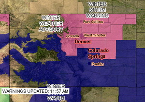
The National Weather Service has issued a Winter Storm Warning for Denver and much of northeastern Colorado in anticipation of a significant storm now approaching the state.  The warning takes the place of the previously issued watch and signifies the increased potential for a major snow event.  The warning goes into effect at 6:00am Thursday morning and runs through 6:00am Friday.

Computer models are beginning to coalesce around solutions that involve snow amounts that could exceed a foot along the Palmer Divide and the foothills.  Snow will begin falling in the foothills in the morning and by midday will encompass the entire Front Range.  By the time the storm ends, much of the metro area will have in excess of six inches of snow.  Tomorrow afternoon’s commute is almost certainly going to be a rough one.

The spring snowstorm could be our biggest storm to date for the 2008 – 2009 winter season.  We are desperately in need of moisture so while it may be troublesome, we really need the precipitation. 

Click here to get all the details on our warning page.

Winter Weather Advisory issued for the Front Range

Current ThorntonWeather.com webcam image.

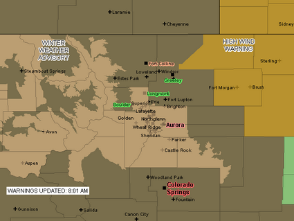
Due to the deteriorating weather conditions, the National Weather Service has issued a Winter Weather Advisory for snow and blowing snow.  Areas under the advisory include the Denver metro area and areas south to Castle Rock as well as some of the mountain areas (see advisory map below).  The storm seems to be lingering over the Front Range longer than expected but the snowfall is still expected to end quickly late this morning.

URGENT – WINTER WEATHER MESSAGE
NATIONAL WEATHER SERVICE DENVER CO
757 AM MST MON JAN 12 2009

..Winter weather advisory in effect until 11 am MST Tuesday…

The National Weather Service in Denver has issued a Winter Weather Advisory for snow and areas of blowing snow…which is in effect until 11 am MST Tuesday.

Snow…heavy at times…will continue within the greater Denver metro area…the southern Front Range foothills and the palmer divide south of Denver. A band of moderate to heavy snow now over the Denver metro area will continue to move south over the palmer divide south of Denver within the next hour. In addition to snowfall…areas of blowing snow will significantly reduce visibilities at times.

Snowfall is expected to taper off rather quickly later this morning…first over the northern Denver metro area and then eventually over the palmer divide and southern foothills by early this afternoon.

Additional snow accumulations by noon today will range from 1 of 3 inches in Boulder and across the northern Denver suburbs to another 3 to
6 inches in the southern Denver and over the palmer divide.

In addition…north winds of 15 to 25 mph will produce areas of blowing snow and very poor visibilities especially over the higher terrain south and southeast of Denver.

A winter weather advisory means that snow…blowing snow…or freezing drizzle will cause travel difficulties. Be prepared for slippery roads and limited visibilities…and use caution while driving.

A Winter Weather Advisory is in effect for much of the Front Range until 11:00am Monday.

White Christmas for half the country as travel woes continue

Old Man Winter brought a white Christmas to much of the northern half of the United States which may be a blessing or a curse depending on your point of view.  Images released by the National Operational Hydrologic Remote Sensing Center  show that many areas that wouldn’t normally expect snow are covered in a blanket of white this Christmas.

Much of the country west of the Continental Divide will have snow or rain Christmas Day.  Areas of the Sierra Nevada and southwestern Colorado will be measuring the snow in feet.  Salt Lake City is expecting 4 to 8 inches while here in Denver we remain dry and will actually have a pretty mild day. 

In the northeast they will have a cold and blustery holiday.  Lake Erie and Lake Ontario will generate some lake-effect snows from Pennsylvania through New York and into northern New England. 

The latest cold blast to hit the nation has caused travel woes across much of it.  In Chicago, 500 flights were canceled on Tuesday stranding many travelers, some of whom won’t be able to reach their destination until today.  100 flights were canceled at O’Hare Wednesday but delays improved as the day went on.  Sadly the weather did have a more serious toll as between Tuesday and Wednesday at least 30 people were killed in crashes on rain- and ice-slickened roads across the nation’s midsection. 

Out west in Washington and Oregon, residents and government officials were wishing for a return to their normal rainy weather as they were unprepared for the snow that has fallen in recent days.  In Portland, Oregon many side streets were impassable without chains or four wheel drive.  Wednesday more snow fell followed by rain which most likely will add to the problems when it freezes tonight.

Washington Governor Chris Gregoire declared a statewide winter storm emergency saying, “A number of counties and cities are struggling to meet the problems posed by this month’s onslaught of snow and winter weather.  Snowfall has reached record or near-record level in 30 of the state’s 39 counties.”  Her proclamation will allow state agencies to support local operations including the activation of the National Guard. 
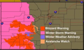
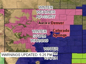
Active weather watches and warnings on Christmas Day.Here in Colorado, much of the western slope is under various types of winter weather advisories.  A Winter Storm Warning covers the western half of the state and Blizzard and Avalanche Warnings cover some areas south of I-70.  Needless to say, Christmas Day travel in the high country will be greatly impeded by these storms.  

Good weather along the eastern part of Colorado has allowed Denver International Airport to operate normally for the most part.  However, some delays were experienced for flights heading to other parts of the nation affected by the winter weather. 
Winter weather preparedness articles added to Weather Education

Please view the Winter Weather Preparedness series to ensure you are ready for the winter!

We recently published a series of articles from the National Weather Service as part of Colorado’s Winter Weather Preparedness Week.  We have now made those stories easier to find by adding them to the Weather Education menu on the left of every page. 

This series of articles is a ‘must read’ for anyone living or traveling in Colorado or any place else that receives severe winter weather.  Covering a wide range of related topics, these articles help ensure you are ready for the coming winter.  The articles cover the following topics:


Part 1 Winter travel safety
Part 2 Watches…warnings…and advisories
Part 3 High winds
Part 4 Wind chill temperatures and hypothermia
Part 5  Avalanche safety
Review  Winter Weather Preparedness Week review