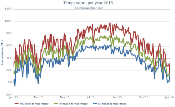
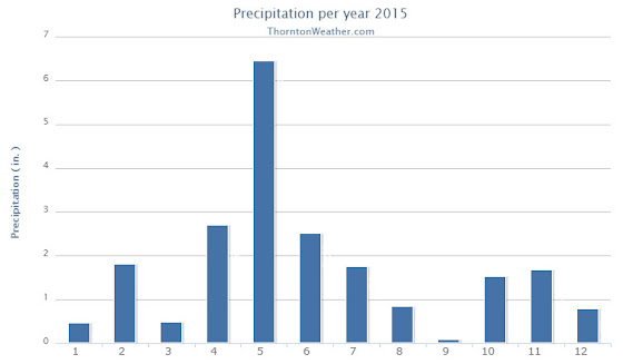
The year that was lacked any major drama in terms of the weather. Winter and severe weather conditions during their seasons were pretty typical. Overall, the year saw temperatures and precipitation end above average.
Thornton’s average annual temperature for 2015 came in at 51.1 degrees. That was a bit above Denver’s historical average of 50.5 degrees. Out at DIA where the Mile High City’s official measurements were taken, the average was 52.0 degrees. Denver’s reading made the year the 18th warmest on record.
Temperatures in Thornton ranged from a high of 98.1 degrees on August XX down to a low of -3.7 degrees on January XX. We saw 44 days of high temperatures at or above 90 degrees and 131 days with low temperatures below the freezing mark.
Out at the airport, Denver saw a maximum of 98 degrees on August 15 and a low of 10 degrees below zero on January 4. Officially the city saw 48 90 degrees days and 126 days with lows below freezing.
Denver averages 39.6 days of 90 degrees temperatures and 156.9 days with lows below 32 degrees.
In terms of precipitation, both Thornton and Denver saw their rain buckets record above normal levels. Thornton measured 20.81 inches while DIA was drier with 18.31 inches. Both marks were well above the annual average of 14.30 inches. For Denver, it was the 25th wettest year on record.
Snow as well finished above normal for the calendar year. Average is 53.8 inches. Thornton recorded a hefty 72.1 inches of the white stuff. Denver lagged us but was still above average with 64.4 inches. February was the snowiest month for both locations with Thornton recording 26.7 inches and Denver 22.4 inches.
Click here to view Thornton’s 2015 climate summary report.


From the National Weather Service:
CLIMATE REPORT
NATIONAL WEATHER SERVICE BOULDER, CO
730 AM MST SAT JAN 2 2016
...................................

...THE DENVER CO CLIMATE SUMMARY FOR THE YEAR OF 2015...

CLIMATE NORMAL PERIOD 1981 TO 2010
CLIMATE RECORD PERIOD 1872 TO 2015

WEATHER         OBSERVED          NORMAL  DEPART  LAST YEAR`S
                 VALUE   DATE(S)  VALUE   FROM    VALUE  DATE(S)
                                          NORMAL
................................................................
TEMPERATURE (F)
RECORD
 HIGH             105   06/26/2012
                        06/25/2012
                        07/20/2005
 LOW              -29   01/09/1875
HIGHEST            98   08/15        64      34      100  07/07
LOWEST            -10   01/04        36     -46      -19  12/30
                                                          02/05
AVG. MAXIMUM     65.4              64.7     0.7     64.6
AVG. MINIMUM     38.6              36.3     2.3     36.5
MEAN             52.0              50.5     1.5     50.5
DAYS MAX >= 90     48              39.6     8.4       29
DAYS MAX <= 32     29              20.0     9.0       24
DAYS MIN <= 32    126             156.9   -30.9      150
DAYS MIN <= 0       7               5.8     1.2       14

PRECIPITATION (INCHES)
RECORD
 MAXIMUM        23.31   1967
 MINIMUM         7.29   2008
TOTALS          18.31             14.30    4.01    18.77
DAILY AVG.       0.05              0.03    0.02     0.05
DAYS >= .01       107              79.7    27.3       98
DAYS >= .10        49              34.9    14.1       44
DAYS >= .50        10               7.6     2.4       10
DAYS >= 1.00        2               2.3    -0.3        4
GREATEST
 24 HR. TOTAL    1.41   04/16 TO 04/17           2.85 07/29 TO 07/30

SNOWFALL (INCHES)
RECORDS
 TOTAL          115.9   1913


 24 HR TOTAL     23.6   12/24/1982 TO 12/24/1982
 SNOW DEPTH        MM   MM
TOTALS           64.4              53.8    10.6     46.1
 LIQUID EQUIV    6.44              5.40    1.04     4.61
SINCE 7/1        22.6              22.5     0.1     16.0
 LIQUID 7/1      2.26              2.20    0.06     1.60
SNOWDEPTH AVG.      0                MM      MM        0
DAYS >= TRACE      51              33.3    17.7       55
DAYS >= 1.0        25              16.3     8.7       17
GREATEST
 SNOW DEPTH         9   02/23                          6  12/31

 STORM TOTAL       10.5                             5.9
 (MM/DD(HH))       02/20 TO 02/23             12/29 TO 12/30

DEGREE_DAYS
HEATING TOTAL    5479              6059    -580     5844
 SINCE 7/1       2187              2468    -281     2291
COOLING TOTAL     877               769     108      701
 SINCE 1/1        877               769     108      701

FREEZE DATES
RECORD
 EARLIEST     09/08/1962
 LATEST       06/08/2007
EARLIEST                        10/07
LATEST                          05/05
..................................................

WIND (MPH)
AVERAGE WIND SPEED              9.6
RESULTANT WIND SPEED/DIRECTION   2/195
HIGHEST WIND SPEED/DIRECTION    46/350    DATE  11/17
HIGHEST GUST SPEED/DIRECTION    60/330    DATE  07/15

SKY COVER
POSSIBLE SUNSHINE (PERCENT)   MM
AVERAGE SKY COVER           0.60
NUMBER OF DAYS FAIR           80
NUMBER OF DAYS PC            208
NUMBER OF DAYS CLOUDY         77

AVERAGE RH (PERCENT)     56

WEATHER CONDITIONS. NUMBER OF DAYS WITH
THUNDERSTORM             71     MIXED PRECIP               0
HEAVY RAIN               14     RAIN                      36
LIGHT RAIN              101     FREEZING RAIN              0
LT FREEZING RAIN          4     HAIL                       5
HEAVY SNOW                9     SNOW                      31
LIGHT SNOW               53     SLEET                      1
FOG                     111     FOG W/VIS <= 1/4 MILE     40
HAZE                     58

-  INDICATES NEGATIVE NUMBERS.
R  INDICATES RECORD WAS SET OR TIED.
MM INDICATES DATA IS MISSING.
T  INDICATES TRACE AMOUNT.

_____________________________________________________________________

..........2015 WAS WETTER AND WARMER THAN NORMAL..........

.........................TEMPERATURES...........................

TEMPERATURES FOR 2015 FINISHED ABOVE NORMAL WITH A MEAN OF 52.0
DEGREES F. WHICH IS 1.5 DEGREES ABOVE NORMAL. THIS MAKES 2015 THE
18TH WARMEST YEAR ON RECORD. THERE WERE 48 DAYS IN WHICH THE
TEMPERATURE REACHED OR EXCEEDED 90 DEGREES AND NO DAYS REACHING THE
CENTURY MARK. AUGUST 15TH WAS THE HOTTEST DAY OF YEAR WITH A
TEMPERATURE OF 98 DEGREES. THERE WERE 4 DAYS DURING THE YEAR IN
WHICH THE TEMPERATURE FELL BELOW ZERO. THE COLDEST TEMPERATURE
RECORDED FOR THE YEAR OCCURRED ON JANUARY 4TH WITH A READING OF TEN
DEGREES BELOW ZERO.

 MONTH    MEAN TEMP  DEPARTURE     WARMEST       COLDEST
         (DEGREES F)FROM NORMAL  (DEGREES F)   (DEGREES F)
JANUARY     33.0       +3.2      40.3(1986)    16.8(1930)
FEBRUARY    33.8       +1.3      43.7(1954)    17.7(1899)
MARCH       45.0       +4.6      50.4(1910)    26.4(1912)
APRIL       48.7       +1.3      56.4(1981)    38.8(1920)
MAY         53.0       -4.1      64.7(1934)    48.7(1917)
JUNE        69.5       +2.1      75.0(2012)    60.6(1967)
JULY        72.8       -1.4      78.9(2012)    67.3(1895)
AUGUST      74.0       +1.5      77.0(2011)    66.5(1915)
SEPTEMBER   69.4       +6.0      69.4(2015)    54.7(1912)
OCTOBER     56.5       +5.6      59.9(1950)    38.9(1969)
NOVEMBER    38.5       +0.2      50.9(1949)    22.0(1930)
DECEMBER    29.4       -0.6      43.8(1933)    17.4(1983)
ANNUAL      52.0       +1.5      54.9(1934)    47.8(1912)

.......................PRECIPITATION............................

2015 WAS A GOOD YEAR FOR PRECIPITATION IN DENVER. THE FINAL TALLY
FOR THE YEAR WAS 18.31 INCHES WHICH IS 4.01 INCHES ABOVE THE NORMAL
OF 14.30 INCHES. THIS MAKES 2015 THE 25TH WETTEST YEAR ON RECORD.

 MONTH PRECIP     DEPARTURE     WETTEST       DRIEST
        (INCHES)  FROM NORMAL  (INCHES)      (INCHES)
JANUARY   0.38      -0.03      2.25(1883)    0.01 (1952...1934...1933)
FEBRUARY  1.25      +0.88      2.01(1934)    0.01(1970)
MARCH     0.79      -0.13      4.56(1900)    0.03(1963)
APRIL     2.65      +0.94      8.24(1900)    0.03(1963)
MAY       3.76      +1.64      8.57(1876)    0.06(1974)
JUNE      2.53      +0.55      4.96(1882)      T (1890)
JULY      1.06      -1.10      6.41(1965)    0.01(1901)
AUGUST    1.18      -0.51      5.85(1979)    0.02(1924)
SEPTEMBER 0.11      -0.85      5.61(2013)      T (1892...1944)
OCTOBER   1.76      +0.74      4.17(1969)      T (1934)
NOVEMBER  2.13      +1.52      3.21(1946)      T (1899...1901...1949)
DECEMBER  0.71      +0.36      5.21(1913)    0.00(1881)
ANNUAL   18.31      +4.01     23.31(1967)    7.29(2008)

...........................SNOWFALL..............................

64.4 INCHES OF SNOW FELL IN 2015...WHICH IS 10.6 INCHES ABOVE THE
NORMAL OF 53.8 INCHES. FEBRUARY 2015 WAS SNOWIEST FEBRUARY ON
RECORD WITH 22.4 INCHES OF SNOW MEASURED AT DENVER INTERNATIONAL
AIRPORT. SNOW ALSO FELL IN DENVER ON CHRISTMAS DAY...WITH 2.3
MEASURED AT THE AIRPORT.

 MONTH  SNOWFALL  DEPARTURE     SNOWIEST      LEAST SNOWIEST
        (INCHES)  FROM NORMAL   (INCHES)         (INCHES)
JANUARY     7.2      -0.2       24.3(1992)      T (2003...1934)
FEBRUARY   22.4     +16.7       22.4(2015)      T (2009)
MARCH       2.9      -7.8       35.2(2003)      T (2012...1995)
APRIL       5.3      -1.5       33.8(1933)      0 (1995...1992...1943...1930)
MAY         4.0      +2.9       15.5(1898)      0 (NUMEROUS YEARS)
SEPTEMBER   0.0      -1.3       17.2(1971)      0 (NUMEROUS YEARS)
OCTOBER     0.0      -4.0       31.2(1969)      0 (NUMEROUS YEARS)
NOVEMBER   11.3      +2.6       42.6(1946)      0 (1995)
DECEMBER   11.3      +2.8       57.4(1913)      0 (1881)
ANNUAL     64.4     +10.6      115.9(1913)    18.9(1887)
