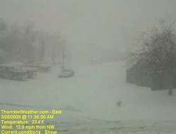
The sun is already beginning to shine in the wake of Denver’s biggest snowstorm of the 2008 – 2009 winter season. The storm was also Denver’s biggest since December 2007 when a series of storms dumped more than 30 inches on the city. While the snow brings much-needed moisture to the parched Front Range, it was a stark contrast to the 70 degree temperatures of just a few days ago.
Here is Thornton we received 11.4 inches of snow from the storm which increases our season total to 38.1 inches. While yesterday’s snow helps, that is still barely half of what we average in a season so much more is needed if we want to make up lost ground.
Cold and wind were also part of the story. Thornton’s high temperature yesterday was 35 degrees but that occurred before 11:00am. Once the storm arrived, the mercury plummetted 15 degrees and we saw temperatures in the mid-teens. Winds are what made the storm a blizzard and we had plenty of that with gusts to 33 mph. The cold temperatures and wind coupled to give us wind chills in the low single digits and Thornton actually recorded a maximum wind chill of 1.3 degrees below zero.
If you haven’t seen it yet, check out these two Thornton weather stories from the blizzard:
- Thornton’s March Blizzard 2009 – Time lapse videos
- City of Thornton will plow residential streets in wake of blizzard
For a complete recap on Denver’s March Blizzard of 2009, see our story on Examiner.com.
| For all the details, read the rest of this story on our Denver Weather Examiner page. |  |
