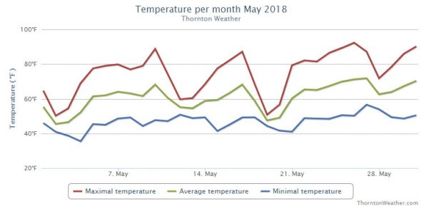
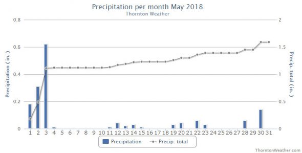
The month of May started off cool and damp but that did not last long. It soon dried out and warmed up leading to one of the warmest Mays on record.
The first three days of the month brought cool temperatures and generous amounts of rain, more than one inch total. We then followed that up with a warming trend that for a week.
Temperatures then cooled for the 12th and 13th of the month then started their upward trend again. Another, short break from the warmth came along from the 18th to the 20th.
After that, the warm weather returned and the last eleven days of the month all saw above normal mercury readings.
While there were a few days with rain after the wet start, none really amounted to much.
Thornton’s average temperature for the month came in at 60.5 degrees. By comparison, Denver’s long term average temperature for May is 57.1 degrees. Out at the airport where Denver’s official readings are taken, the month’s average temperature was warmer than ours at 61.4 degrees. That made the month the eight warmest May in Denver history.
Thornton saw its warmest temperature reading for the month of 92.4 degrees on the 26th of the month. The lowest reading of 35.4 degrees fell on the 4th. Denver saw its warmest reading of 94 degrees on the same day we saw our warmest and its coldest of 40 degrees on the 20th.
Denver set a record high temperature on the 10th and tied the record high temperature for the 25th. Additionally, the Mile High City saw four days with high temperatures at or above the 90 degree mark (Thornton had three). This breaks the record for the number of 90 degree days in May which previously was three days set in 1989 and 1874.
In terms of precipitation, Denver averages 2.12 inches during May. Thornton fell well short with 1.59 inches in our bucket. The Mile High City fared better, but still below normal, with 1.86 inches.
No snow fell during the month in Thornton or Denver.
Click here to view Thornton’s May 2018 climate report.


CLIMATE REPORT
NATIONAL WEATHER SERVICE DENVER/BOULDER CO
942 AM MDT FRI JUN 1 2018

...................................

...THE DENVER CO CLIMATE SUMMARY FOR THE MONTH OF MAY 2018...

CLIMATE NORMAL PERIOD 1981 TO 2010
CLIMATE RECORD PERIOD 1872 TO 2018

WEATHER         OBSERVED          NORMAL  DEPART  LAST YEAR`S
                 VALUE   DATE(S)  VALUE   FROM    VALUE  DATE(S)
                                          NORMAL
................................................................
TEMPERATURE (F)
RECORD
 HIGH              95   05/26/1942
 LOW               19   05/02/2013
                        05/03/1907
HIGHEST            94   05/26                         86  05/06
LOWEST             40   05/20                         32  05/04
                        05/03
                        05/02
AVG. MAXIMUM     75.4              71.5     3.9     69.6
AVG. MINIMUM     47.5              42.7     4.8     42.3
MEAN             61.4              57.1     4.3     55.9
DAYS MAX >= 90      4               0.8     3.2        0
DAYS MAX <= 32      0               0.0     0.0        0
DAYS MIN <= 32      0               1.9    -1.9        1
DAYS MIN <= 0       0               0.0     0.0        0

PRECIPITATION (INCHES)
RECORD
 MAXIMUM         8.57   1876
 MINIMUM         0.06   1974
TOTALS           1.86              2.12   -0.26     3.66
DAILY AVG.       0.06              0.07   -0.01     0.12
DAYS >= .01         8               9.4    -1.4       17
DAYS >= .10         5               4.8     0.2       11
DAYS >= .50         0               1.2    -1.2        2
DAYS >= 1.00        0               0.2    -0.2        1
GREATEST
 24 HR. TOTAL    0.49   05/03 TO 05/03           05/18 TO 05/18

SNOWFALL (INCHES)
TOTALS            0.0               1.1

DEGREE_DAYS
HEATING TOTAL     151               265    -114      281
 SINCE 7/1       5401              5996    -595     5084
COOLING TOTAL      46                21      25        6
 SINCE 1/1         48                22      26        6

FREEZE DATES
RECORD
 EARLIEST     09/08/1962
 LATEST       06/08/2007
EARLIEST                        10/07
LATEST                          05/05
.................................................................

WIND (MPH)
AVERAGE WIND SPEED              9.9
RESULTANT WIND SPEED/DIRECTION   1/116
HIGHEST WIND SPEED/DIRECTION    36/330    DATE  05/30
HIGHEST GUST SPEED/DIRECTION    52/330    DATE  05/30

SKY COVER
POSSIBLE SUNSHINE (PERCENT)   MM
AVERAGE SKY COVER           0.60
NUMBER OF DAYS FAIR            6
NUMBER OF DAYS PC             15
NUMBER OF DAYS CLOUDY         10

AVERAGE RH (PERCENT)     57

WEATHER CONDITIONS. NUMBER OF DAYS WITH
THUNDERSTORMS            11   MIXED PRECIP           3
HEAVY RAIN                2   RAIN                   2
LIGHT RAIN               11   FREEZING RAIN          0
LT FREEZING RAIN          0   HAIL                   3
HEAVY SNOW                0   SNOW                   0
LIGHT SNOW                0   FOG W/VIS <=1/4 MILE   6
FOG                      10   HAZE                   3

-  INDICATES NEGATIVE NUMBERS.
R  INDICATES RECORD WAS SET OR TIED.
MM INDICATES DATA IS MISSING.
T  INDICATES TRACE AMOUNT.
