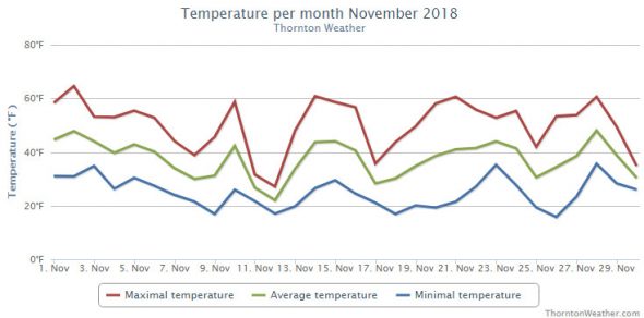
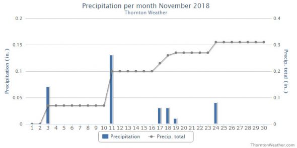
Thornton’s month of November saw us get a real taste of what is to come for the next few months. Temperatures cooled considerably and we saw a decent bit of snow although not as much as normal.
The first five days of the month started out relatively mild but then we saw a series of systems interrupt the calm. Temperatures turned colder and on the 11th and 12th we received a nice little snowfall. We briefly warmed up then saw some light rain on the 18th and 19th and then once again warmed back up. The month closed out with a chilly day and some light snow.
Thornton saw an overall average temperature for the month of 36.8 degrees. This was a good bit colder than Denver’s long term average for the month of 38.3 degrees. Out at DIA where Denver’s official measurements are taken, it was a good bit warmer with an average of 37.8 degrees.
Temperatures for us ranged from a high of 64.7 degrees on the 2nd of the month down to a cold low of 15.7 degrees on the morning of the 26th. Denver’s high of 65 degrees on the 2nd matched ours but their coldest reading of 10 on the 12th was notably colder than our lowest reading.
November’s long term precipitation average in Denver is 0.61 inches. Thornton managed about half that in our bucket with 0.31 inches with Denver close to us at 0.35 inches.
Snowfall was respectable but not notable. Thornton recorded 6.3 inches of the white stuff while Denver, as usual, lagged with 4.5 inches. Both measurements were below Denver’s long term November average of 8.7 inches.
Click here to view Thornton’s November 2018 climate report.


CLIMATE REPORT
NATIONAL WEATHER SERVICE DENVER/BOULDER CO
929 AM MST MON DEC 3 2018

...................................

...THE DENVER CO CLIMATE SUMMARY FOR THE MONTH OF NOVEMBER 2018...

CLIMATE NORMAL PERIOD 1981 TO 2010
CLIMATE RECORD PERIOD 1872 TO 2018

WEATHER         OBSERVED          NORMAL  DEPART  LAST YEAR`S
                 VALUE   DATE(S)  VALUE   FROM    VALUE  DATE(S)
                                          NORMAL
................................................................
TEMPERATURE (F)
RECORD
 HIGH              81   11/27/2017
 LOW              -18   11/29/1877
HIGHEST            65   11/02        73      -8       81  11/27
LOWEST             10   11/12        -6      16       22  11/15
                                                          11/12
AVG. MAXIMUM     50.6              52.1    -1.5     61.1
AVG. MINIMUM     25.0              24.5     0.5     29.4
MEAN             37.8              38.3    -0.5     45.3
DAYS MAX >= 90      0               0.0     0.0        0
DAYS MAX <= 32      2               2.3    -0.3        0
DAYS MIN <= 32     27              23.4     3.6       22
DAYS MIN <= 0       0               0.6    -0.6        0

PRECIPITATION (INCHES)
RECORD
 MAXIMUM         3.21   1946
 MINIMUM            T   1899
                        1901
                        1949
TOTALS           0.35              0.61   -0.26     0.29
DAILY AVG.       0.01              0.02   -0.01     0.01
DAYS >= .01         6               4.7     1.3        3
DAYS >= .10         1               1.6    -0.6        1
DAYS >= .50         0               0.0     0.0        0
DAYS >= 1.00        0               0.0     0.0        0
GREATEST
 24 HR. TOTAL    0.17   11/11 TO 11/11           11/17 TO 11/17

SNOWFALL (INCHES)
RECORDS
TOTAL             4.5               8.7
RECORD NOVEMBER  42.5  1946

DEGREE_DAYS
HEATING TOTAL     808               801       7      586
 SINCE 7/1       1373              1382      -9     1171
COOLING TOTAL       0                 0       0        0
 SINCE 1/1       1026               769     257      881

FREEZE DATES
RECORD
 EARLIEST     09/08/1962
 LATEST       06/08/2007
EARLIEST                        10/07
LATEST                          05/05
.................................................................

WIND (MPH)
AVERAGE WIND SPEED              9.8
RESULTANT WIND SPEED/DIRECTION   2/225
HIGHEST WIND SPEED/DIRECTION    48/330    DATE  11/24
HIGHEST GUST SPEED/DIRECTION    62/320    DATE  11/24

SKY COVER
POSSIBLE SUNSHINE (PERCENT)   MM
AVERAGE SKY COVER           0.50
NUMBER OF DAYS FAIR            8
NUMBER OF DAYS PC             16
NUMBER OF DAYS CLOUDY          6

AVERAGE RH (PERCENT)     56

WEATHER CONDITIONS. NUMBER OF DAYS WITH
THUNDERSTORMS             0      MIXED PRECIP       0
HEAVY RAIN                0      RAIN               0
LIGHT RAIN                2      FREEZING RAIN      0
LIGHT FREEZING RAIN       1      HAIL               0
HEAVY SNOW                0      SNOW               3
LIGHT SNOW                9      SLEET              0
FOG                       8      DENSE FOG          2
HAZE                      2

-  INDICATES NEGATIVE NUMBERS.
R  INDICATES RECORD WAS SET OR TIED.
MM INDICATES DATA IS MISSING.
T  INDICATES TRACE AMOUNT.
