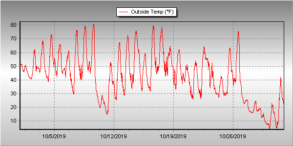
There is little doubt that when folks’ memories go back October 2019’s weather, they will remember the snow and even more so, the cold. Numerous cold temperature records were broken and the month ended up as one of the coldest Octobers on record.
Things started off cool for the first few days and a bit of precipitation. We then warmed up and dried out, seeing our warmest temperatures of the month on the 7th, 8th and 9th. From there, it was mostly downhill.
The evening of the 9th saw a powerful storm system and cold front move across northeastern Colorado. Temperatures plummeted and we saw our first snowfall of the season. Denver officially saw a 70 degree temperature change from the 9th to the 10th, tying the period for the second largest two-day temperature swing in Denver history.
High pressure returned on the 12th and we warmed up and dried out again. Cool but non-dramatic conditions arrived for the 18th through the 23rd. We then saw our second snowfall on the 24th of the month.
A brief rebound saw us warm up and enjoy a day of warmer than normal temperatures on the 26th. Once again, Mother Nature dropped the hammer with cold and snow returning on the 27th. The final five days of the month saw us receive two shots of snow and temperatures more akin to what we would expect to see in January.
Overall, Thornton’s average temperature for the month was 42.8 degrees. This was far below the long term Denver average for October of 50.9 degrees and was Thornton’s second coldest October since ThorntonWeather.com came online in the fall of 2006.
Out at Denver International Airport where the Mile High City’s official measurements are taken, it was slightly warmer with an average of 43.7 degrees. That made the month the fourth coldest October in Denver weather history.
Denver saw six cold weather daily temperature records fall. Among them were a record low of 13 degrees on the 10th, a record low on the 11th, record low maximums on the 28th and the 29th, and then two more record low temperatures on the 30th and 31st.
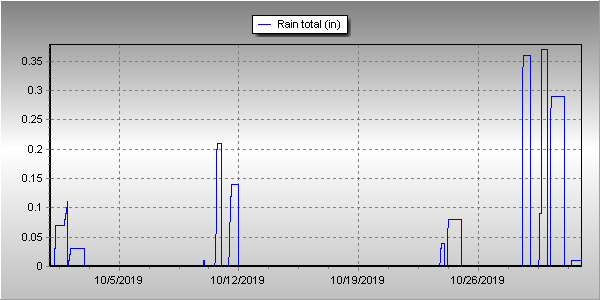
In terms of precipitation, Denver averages 1.02 inches of liquid during the month of October. Thornton bested that handily with 1.54 inches in our rain bucket. At DIA, it was drier with only 0.91 inches officially.
Snow was abundant in Thornton and Denver. Thornton received 17.6 inches of the white stuff while Denver came in at 12.5 inches. The Denver measurement made the month the 12th snowiest in Denver weather history.
Click here to view Thornton’s October 2019 climate report.


CLIMATE REPORT
NATIONAL WEATHER SERVICE DENVER/BOULDER CO
230 PM MDT FRI NOV 1 2019

...................................

...THE DENVER CO CLIMATE SUMMARY FOR THE MONTH OF OCTOBER 2019...

CLIMATE NORMAL PERIOD 1981 TO 2010
CLIMATE RECORD PERIOD 1872 TO 2019

WEATHER         OBSERVED          NORMAL  DEPART  LAST YEAR`S
                 VALUE   DATE(S)  VALUE   FROM    VALUE  DATE(S)
                                          NORMAL
................................................................
TEMPERATURE (F)
RECORD
 HIGH              90   10/01/1892
 LOW               -2   10/29/1917
HIGHEST            83   10/09        83       0       86  10/03
LOWEST              3   10/30        22     -19       18  10/15
AVG. MAXIMUM     58.5              65.3    -6.8     61.5
AVG. MINIMUM     28.9              36.6    -7.7     36.8
MEAN             43.7              50.9    -7.2     49.2
DAYS MAX >= 90      0               0.0     0.0        0
DAYS MAX <= 32      5               0.4     4.6        1
DAYS MIN <= 32     18               8.5     9.5        7
DAYS MIN <= 0       0               0.0     0.0        0
PRECIPITATION (INCHES)
RECORD
 MAXIMUM 4.17 1969
 MINIMUM T 1934
 TOTALS          0.91              1.02   -0.11     0.99
DAILY AVG.       0.03              0.03    0.00     0.03
DAYS >= .01         9               5.3     3.7        9
DAYS >= .10         4               2.4     1.6        3
DAYS >= .50         0               0.5    -0.5        0
DAYS >= 1.00        0               0.1    -0.1        0
GREATEST
 24 HR. TOTAL    0.22   10/29 TO 10/29

SNOWFALL (INCHES)
RECORDS
 TOTAL           12.5               4.0
RECORD OCTOBER   31.2   1969

DEGREE_DAYS
HEATING TOTAL     653               440     213      487
 SINCE 7/1        675               581      94      565
COOLING TOTAL       1                 5      -4        4
 SINCE 1/1        916               769     147     1026

FREEZE DATES
RECORD
 EARLIEST     09/08/1962
 LATEST       06/08/2007
EARLIEST      10/09             10/07
LATEST                          05/05
.................................................................

WIND (MPH)
AVERAGE WIND SPEED              10.0
RESULTANT WIND SPEED/DIRECTION   1/209
HIGHEST WIND SPEED/DIRECTION    46/040    DATE  10/09
HIGHEST GUST SPEED/DIRECTION    57/030    DATE  10/09

SKY COVER
POSSIBLE SUNSHINE (PERCENT)   MM
AVERAGE SKY COVER           0.40
NUMBER OF DAYS FAIR           13
NUMBER OF DAYS PC             13
NUMBER OF DAYS CLOUDY          5

AVERAGE RH (PERCENT)     51


-  INDICATES NEGATIVE NUMBERS.
R  INDICATES RECORD WAS SET OR TIED.
MM INDICATES DATA IS MISSING.
T  INDICATES TRACE AMOUNT.
