Last night and this morning the metro area received a nice little bit of snow, something which was desperately needed. The northern and western suburbs received more than the rest of the metro area. Areas like Thornton and Broomfield are reporting around 4 inches while Centennial and Parker are just a bit more than an inch. Officially, the National Weather Service reported 1.3 inches at the old Stapleton International Airport site.
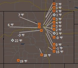
The big story though isn’t the snow – it is the frigid cold that is accompanying it. Denver International Airport has reported temperatures as low as 3 degrees below zero and the wind chills are into the negative teens. Currently stations on the Rocky Mountain Weather Network are reporting low single digit temperatures across the Front Range.
Today most of the metro area will remain in the single digits with Denver reaching a high of around 9 degrees. Tonight will be equally frigid and drop to 2 below zero. There will be some minor warming during the work week but it won’t be much and it will be the latter half of the week before we see temperatures above freezing. A chance for snow will also remain each day and night with the best chance being Monday night into Tuesday morning.

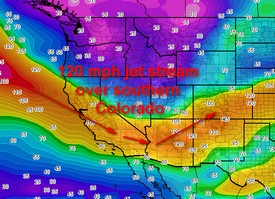
This cold air is being drawn down by a rather powerful jet stream that has set in over the southern part of Colorado. Areas to our north in Wyoming, Montana and the Dakotas have it much worse than us – Spearfish, SD recorded -13 degrees with a -22 degree wind chill this morning!
With the severe cold and the snow, now might be good time to take a look at our Winter Weather Preparedness series:
| Part 1 | Winter travel safety |
| Part 2 | Watches…warnings…and advisories |
| Part 3 | High winds |
| Part 4 | Wind chill temperatures and hypothermia |
| Part 5 | Avalanche safety |
| Review | Winter Weather Preparedness Week review |
