High winds have hit the Front Range with gusts exceeding 80mph in some areas. These winds are extremely gusty and have the potential to cause damage and can make driving conditions difficult.
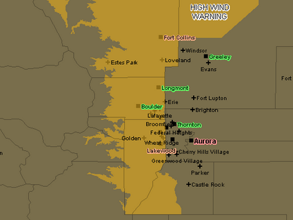
A High Wind Warning remains in effect for much of the Front Range and foothills until 8:00am (see area map below). While Thornton is not in the warning area, we have received our fair share as ThorntonWeather.com recorded a 51mph gust earlier this morning. In the near term, west winds of 15 to 30 mph gusting to 45 mph are expected all along the I-25 corridor. Gusts as high as 75 mph will occur near the base of the foothills and areas in northern Jefferson County, Boulder County and Larimer County in particular will receive the highest winds.
These winds will cause blowing dust and drivers on north-south roads need to be wary as the cross winds could cause a loss of control. It would not be surprising to hear of accidents with light weight or high profile vehicles this morning. Power outages are of course a possibility as well.
From the National Weather Service, here are some of the recorded gusts across the Front Range:
| 05:48 AM 12/30/2008 REPORTED BY: ASOS BROOMFIELD COUNTY, CO – 2 MILES WEST-NORTHWEST OF BROOMFIELD |
| NON-T-STORM WIND GUST MEASURED AT 78.00 MPH ROCKY MOUNTAIN REGIONAL AIRPORT |
| 05:48 AM 12/30/2008 REPORTED BY: TRAINED SPOTTER LARIMER COUNTY, CO – MASONVILLE |
| NON-T-STORM WIND GUST MEASURED AT 59.00 MPH |
| 05:15 AM 12/30/2008 REPORTED BY: TRAINED SPOTTER BOULDER COUNTY, CO – 1 MILE SOUTHWEST OF ERIE |
| NON-T-STORM WIND GUST MEASURED AT 77.00 MPH |
| 04:45 AM 12/30/2008 REPORTED BY: TRAINED SPOTTER BOULDER COUNTY, CO – 1 MILE SOUTHWEST OF ERIE |
| NON-T-STORM WIND GUST MEASURED AT 66.00 MPH |
| 04:20 AM 12/30/2008 REPORTED BY: MESONET BOULDER COUNTY, CO – 2 MILES SOUTHWEST OF BOULDER |
| NON-T-STORM WIND GUST MEASURED AT 69.00 MPH NCAR MESA LAB |
| 03:28 AM 12/30/2008 REPORTED BY: TRAINED SPOTTER WELD COUNTY, CO – 21 MILE NORTH OF NEW RAYMER |
| NON-T-STORM WIND GUST MEASURED AT 76.00 MPH |
| 02:48 AM 12/30/2008 REPORTED BY: TRAINED SPOTTER JEFFERSON COUNTY, CO – LAKEWOOD |
| NON-T-STORM WIND GUST MEASURED AT 66.00 MPH |
| 02:10 AM 12/30/2008 REPORTED BY: MESONET BOULDER COUNTY, CO – 1 MILE WEST OF ELDORADO SPRINGS |
| NON-T-STORM WIND GUST MEASURED AT 66.00 MPH |
| 12:30 AM 12/30/2008 REPORTED BY: MESONET BOULDER COUNTY, CO – 2 MILES NORTH-NORTHEAST OF BOULDER |
| NON-T-STORM WIND GUST MEASURED AT 67.00 MPH |
| 12:30 AM 12/30/2008 REPORTED BY: MESONET JEFFERSON COUNTY, CO – 9 MILES WEST-SOUTHWEST OF BOULDER |
| NON-T-STORM WIND GUST MEASURED AT 82.00 MPH ROCKY FLATS – NATIONAL WIND TECHNOLOGY CENTER |
| 11:15 PM 12/29/2008 REPORTED BY: TRAINED SPOTTER BOULDER COUNTY, CO – 2 MILES NORTH OF LONGMONT |
| NON-T-STORM WIND GUST MEASURED AT 84.00 MPH |
| 10:39 PM 12/29/2008 REPORTED BY: TRAINED SPOTTER LARIMER COUNTY, CO – BERTHOUD |
| NON-T-STORM WIND GUST MEASURED AT 91.00 MPH CARTER LAKE |
| 09:36 PM 12/29/2008 REPORTED BY: TRAINED SPOTTER BOULDER COUNTY, CO – 2 MILES NORTH OF LONGMONT |
| NON-T-STORM WIND GUST MEASURED AT 71.00 MPH |
| 09:14 PM 12/29/2008 REPORTED BY: MESONET JEFFERSON COUNTY, CO – ROCKY FLATS |
| NON-T-STORM WIND GUST MEASURED AT 78.00 MPH |
| 09:06 PM 12/29/2008 REPORTED BY: TRAINED SPOTTER LARIMER COUNTY, CO – BERTHOUD |
| NON-T-STORM WIND GUST MEASURED AT 88.00 MPH AT CARTER LAKE |
| 07:35 PM 12/29/2008 REPORTED BY: MESONET BOULDER COUNTY, CO – 2 MILES SOUTH OF BOULDER |
| NON-T-STORM WIND GUST MEASURED AT 65.00 MPH NCAR MESA LABS |
| 07:21 PM 12/29/2008 REPORTED BY: MESONET BOULDER COUNTY, CO – 3 MILES EAST OF GOLD HILL |
| NON-T-STORM WIND GUST MEASURED AT 81.00 MPH |


One thought on “Strong winds hit Thornton and the Front Range”