|
METRIC |
IMPERIAL
|
Updated:
04-Jun-2025 @ 5:10am
(0 sec ago)
|
| Temperature |
Current Conditions |
Forecast / Storm Prediction |
Currently Outside:

50.5°F
24-hr diff:
3.6°F
Cool
|
High Today
51.2°F
1:56 AM |
Low Today
50.5°F
3:42 AM |
Yest High
56.3°F
1:45 PM |
Yest Low
45.9°F
9:51 AM |
Sta* High
93.4°F
2018 |
Sta* Low
46.8°F
2019 |
|
* This Station's Records Since 11/2006 |
|
|
|

|
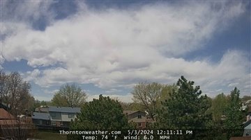
Dawn, Dry, Mostly cloudy
|

|
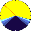
Wind:
SE
0.0
Gusting to:
0.0 mph
|
 |
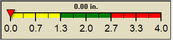
Rain:
0.00 in
|

|
Current CBI
Fire Danger:
-1.0 of 100
|
|
Overnight

Mostly Cloudy
|
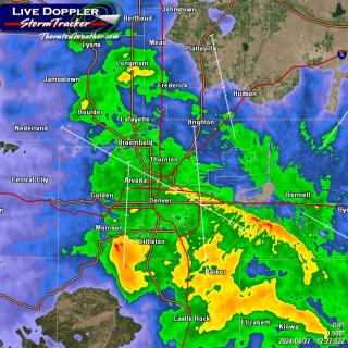
Wednesday

Slight Chance Rain Showers then Chance Showers And T-Storms
|
Wednesday
Night

Chance Showers And T-Storms
|
|
Lo 49.0°F |
Hi 73.0°F |
Lo 52.0°F |

|
|
| Dew Point |
Liquid Precipitation |
Wind Speed |
Sun/Moon |
| Current: |
46.5°F
|
| Last Hour: |
-31.8°F
|
| High 12:04 AM: |
48.8°F
|
| Low 3:20 AM: |
45.9°F
|
| Record High: |
73.2°F
3-Aug-2007 |
| Record Low: |
-17.3°F
16-Jan-2024 |
| Wetbulb: |
48.5°F
|
|
Rain Today
|
|
Today:
|
0.00 in
|
| Storm Rain: |
0.43 in
|
| Yesterday: |
0.41 in
|
| Last 7 Days: |
0.76 in
|
| Jun Rain: |
0.43 in
|
Jun to Date
Avg:10
|
0.30 in
|
Jun to Date
Diff from Avg:10
|
0.13 in
|
| Jun Avg: |
1.43 in
|
| Diff from Avg: |
1.00 in
|
| Season:1 |
6.13 in
|
YTD
Avg:11
|
7.06 in
|
YTD
Diff from Avg:11
|
0.93 in
|
Last Rain
Time/Date: |
3-Jun-2025
at 9:18 PM |
|
38 rain days in 2025 |
2 days in June
0 days since last rain |
|
| Current: |
SE
0.0 mph
|
| 1Hr Average: |
0.6 mph
|
| Wind Run: |
2.73 miles
|
|
Wind Gust |
| Current: |
0.0 mph
|
| Today: |
11.5 mph 3:11 AM
|
| Month: |
22.0 mph
1-Jun |
| Year: |
47.2 mph
3-Mar |
| Record Gust: |
62.1 mph
17-Apr-2018 |
|
Sunlight:
14 h 54 m 42 s
of Sunlight Yesterday
14 h 55 m 41 s
of Sunlight Today
Which is 59 sec longer than
yesterday
14 h 56 m 35 s
of Sunlight Tomorrow
(Noon)
 (Midnight)
|
|
Waxing Gibbous
|

|
62%
Illuminated |
|
| Humidity |
Barometer |
| Current: |
86%
|
| Last Hour: |
1% |
| High 12:04 AM: |
92% |
| Low 2:49 AM: |
84% |
| Record High: |
100%
12-Feb-2007 |
| Record Low: |
0%
1-Jan-2008 |
|
| Current: |
29.750 inHg
|
| Last Hour: |
Steady
|
| High 12:00 AM: |
29.819
|
| Low 4:46 AM: |
29.745
|
| Record High: |
31.09 inHg
30-Dec-2014 |
| Record Low: |
25.13 inHg
17-Dec-2006 |
|
|
Heating Degree Days |
Snow3 |
Wind Chill |
Air |
| Today: |
2.9 |
| Jun: |
17.1 |
| 2025 to Date: |
3373.7 |
|
Cooling Degree Days |
| 2025 to Date: |
23.9 |
|
| Today: |
0.00 in
|
| Yesterday: |
0.00 in
|
| Jun Snow: |
 0.00 in 0.00 in
|
| Jun Avg: |
0.00 in
|
| Diff from Avg: |
0.00 in
|
| Season Total:2 |
36.90 in
|
| Snow Depth: |
0.00 in
|
|
0 snow days in June |
|
20 snow days this season.2
|
First Snow of Season:
6-Nov-2024 |
Average 1st Snow:
27 of Oct |
|
| Current: |
50.5°F
|
| Low 3:42 AM: |
50.5°F
|
| Yesterday: |
42.3°F
|
| Record: |
-31.0°F
22-Dec-2022 |
|
Quality
Index6:
40

Density:
1.23 kg/m3 |
|
| UV Summary/Forecast |
Solar Summary |
|
High Yest:
6.4 @ 1:41 PM
|
Jun-04

9.5
|
Jun-05
10.1
|
Jun-06
10.0
|
|
|
High Yest:
831.0 @ 10:46 AM
|
Sun Hours Today:
00:00
This Month: 06:54 Hrs
|
| Rise:
5:32 am Set: 8:23 pm |
|
| Almanac |
Irrigation Index5 |
Station All Time Records |
Cloud Level
|
| Currently: |
Early Morning |
| YTD Avg Temp: |
43.3°F
|
| Sunrise: |
5:32 am |
| Sunset: |
8:23 pm |
| Moonrise: |
2:26 pm |
| Moonset: |
1:58 am |
| Full Moon: |
11-Jun-2025 |
| New Moon: |
10:32 UTC
25-Jun-2025 |
|
| Updated at Midnight |
| Current ET: |
0.01 in
|
| 7-Days Rain: |
0.76 in
|
| 7-Days ET: |
0.91 in
|
|
7-Day: |
0.15 in
|
|
June: |
0.00 in
|
| Support this Site! |
|
Your donation helps support this site
|
|
| HIGHS: |
LOWS: |
102.9°F
25-Jun-2012 |
-14.6°F
2-Feb-2011 |
| Daytime Records |
100.6°F
12-Jul-2024 |
-8.1°F
22-Dec-2022 |
| Nitetime Records |
88.0°F
15-Aug-2012 |
-10.7°F
02-Feb-2011 |
ICN:1 | S3C2:1 | Ajax 3.xx
ISS:Ok | CON:4.7 | RCP:99% |
|

|